
Hurricane Milton has been a significant weather event, impacting Florida and surrounding regions. Originating in the Gulf of Mexico, this storm rapidly intensified, causing widespread concern and prompting emergency responses. This article provides an updated overview of Hurricane Milton’s current location, its path, and the effects it has had, particularly focusing on answering the crucial question: Where Is The Hurricane Now?
Initially making landfall as a Category 3 hurricane, Milton brought strong winds, heavy rainfall, and dangerous storm surges to Florida. While it has since weakened to a post-tropical cyclone and moved offshore into the Atlantic, its impact continues to be felt. Understanding the storm’s trajectory and current status is vital for those in affected areas and anyone tracking hurricane activity.
Current Location of Hurricane Milton
According to the latest advisory from the National Hurricane Center (NHC) at 5:00 PM EST on Thursday, Hurricane Milton, now a post-tropical cyclone, was located approximately 710 miles west-southwest of Great Abaco Island in the northern Bahamas. This position indicates that the storm’s center has moved away from Florida and is tracking across the Atlantic Ocean.
Despite being classified as post-tropical, Milton still carries significant weather threats. Forecasters are warning that swells generated by Milton will continue to affect parts of the southeastern United States and the Bahamas for the next couple of days. These swells are capable of causing life-threatening surf and rip current conditions along coastlines. Furthermore, the NHC predicts that the center of the post-tropical cyclone will pass south of Bermuda late on Friday.
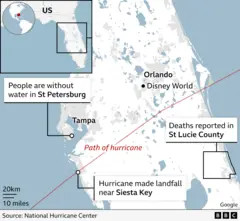 Map of Hurricane Milton's path across Florida, highlighting landfall near Siesta Key and impact zones.
This map illustrates Hurricane Milton’s trajectory across central Florida, pinpointing its landfall near Siesta Key. Key locations like St. Petersburg, Tampa, Orlando, and St. Lucie County are labeled to indicate areas experiencing water outages or reported fatalities.
Impact of Hurricane Milton on Florida
Hurricane Milton made landfall near Siesta Key, Florida, at approximately 8:30 PM EST on Wednesday, as a category three hurricane. The immediate aftermath saw widespread power outages, with nearly 3.4 million homes and businesses losing electricity by Thursday morning. The storm’s powerful winds and torrential rain have led to dozens of homes being destroyed and, tragically, at least four reported deaths.
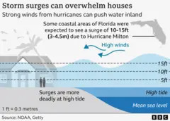
Beyond the immediate coastal areas, the impact of Milton extended inland and along Florida’s eastern coast. Torrential rain and flash flooding remain significant concerns, and warnings for high winds and storm surges along the north-eastern coast of Florida are still in effect. Storm surges, where ocean water is pushed inland, pose a serious threat of coastal flooding.
Adding to the complexity, numerous tornado warnings were issued across Florida as a result of Hurricane Milton. Florida’s Chief Financial Officer, Jimmy Patronis, reported approximately 130 tornado warnings. Governor Ron DeSantis confirmed that at least 19 tornadoes had touched down within the state, further compounding the damage and danger.
 BBC annotated graphic depicting Hurricane Milton making landfall in Florida.
This annotated graphic from the BBC visually represents Hurricane Milton’s landfall in Florida, emphasizing the time of impact and the storm’s classification as a Category 3 hurricane.
Hurricane Milton’s Path and Timeline
Hurricane Milton’s journey began in the Gulf of Mexico, where it rapidly intensified due to unusually warm waters. It tracked eastward towards the Florida peninsula, making landfall on the western coast near Siesta Key. The storm moved quickly across the state, impacting major population centers including areas near Tampa and Orlando.
After crossing Florida, Milton weakened as it moved over land, eventually being downgraded to a post-tropical cyclone as it entered the Atlantic Ocean. Despite the weakening classification, the storm’s large size means its effects are felt across a wide area, including Georgia and South Carolina, in addition to most of Florida. These regions experienced heavy rainfall and strong winds as the storm system passed through.
This annotated BBC map visually tracks Hurricane Milton’s path, indicating its movement from the Gulf of Mexico, landfall in Florida near Tampa after 2:00 AM Thursday, and passage near Orlando before 2:00 PM the same day.
Understanding Hurricane Formation and Categories
Hurricanes, also known as cyclones or typhoons in different parts of the world, are powerful tropical storms characterized by strong winds and heavy rainfall. They form over warm ocean waters, typically in tropical regions. The process begins when warm, moist air rises from the ocean surface. As this air rises and cools, it condenses to form clouds.
Under certain atmospheric conditions, this system can organize and intensify. If the rising air at the top of the storm moves away faster than it is replaced at the surface, the surface pressure drops. This lower pressure draws in more air, accelerating winds and further strengthening the hurricane.
Hurricanes are categorized using the Saffir-Simpson scale, which ranges from Category 1 to Category 5, based on sustained wind speeds. Category 5 is the most intense, characterized by winds exceeding 157 mph and causing catastrophic damage. While Hurricane Milton reached Category 5 status at one point, it made landfall in Florida as a Category 3 storm and was later downgraded as it moved inland and offshore.
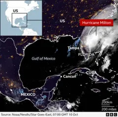 Satellite image showing Hurricane Milton positioned over Florida, with location markers for Tampa, Mexico, and Cuba.
This annotated satellite image from BBC News displays Hurricane Milton’s location as it traverses Florida, with geographical markers for Tampa within Florida, and the countries of Mexico and Cuba in the broader region.
The Role of Climate Change in Hurricane Intensity
The rapid intensification of Hurricane Milton as it moved over the Gulf of Mexico has raised questions about the influence of climate change. Sea surface temperatures in the Gulf have been unusually warm, approximately 1-2°C above average. Warmer ocean waters provide more energy for hurricanes, potentially leading to stronger winds and faster intensification.
Furthermore, a warmer atmosphere can hold more moisture, increasing the potential for intense rainfall from hurricanes. Global sea levels have also been rising due to global warming, which exacerbates storm surge flooding in coastal areas. In Florida, sea levels have risen by more than 7 inches since 1970.
While a comprehensive scientific analysis is needed to definitively attribute Hurricane Milton’s intensity to climate change, its rapid strengthening aligns with predictions of how hurricanes are expected to change in a warming world. The increased intensity and rainfall associated with such storms pose growing risks to coastal communities.
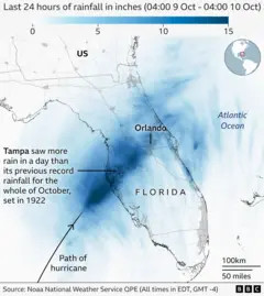 Map displaying rainfall intensity across Florida over a 24-hour period due to Hurricane Milton.
This rainfall map of Florida illustrates the distribution and intensity of rain over a 24-hour period due to Hurricane Milton, showing higher rainfall concentration over Tampa and Orlando.
Conclusion: Staying Informed as Milton Moves On
While Hurricane Milton is now a post-tropical cyclone moving away from Florida and into the Atlantic, its effects are still being felt. Residents in Florida and along the southeastern US coast should remain aware of potential rip currents and dangerous surf conditions. The storm’s passage has left a significant impact, highlighting the destructive power of hurricanes and the importance of preparedness. Staying informed through official sources like the National Hurricane Center is crucial for ongoing safety and recovery efforts.