Argentina, a land of vibrant culture, passionate tango, and breathtaking landscapes, beckons travelers and geography enthusiasts alike. But before you pack your bags or delve into its rich history, a fundamental question arises: Where Is Argentina Located? This South American nation occupies a significant portion of the continent’s southern cone, boasting a vast and diverse territory that stretches from subtropical northern regions to the subantarctic landscapes of Patagonia. Understanding Argentina’s precise location is key to appreciating its geographical diversity, climate variations, and its role in South America and the world. Let’s embark on a journey to pinpoint Argentina’s location and explore the geographical context that shapes this fascinating country.
Argentina’s Continental Location: South America and Beyond
Argentina is undeniably a South American nation, claiming a major part of the continent’s southern region. To be geographically precise, Argentina is situated in the Southern Hemisphere, occupying almost the entirety of the southern part of South America. Imagine South America as an inverted triangle; Argentina forms the majority of the lower portion of this triangle. This strategic location places Argentina in a unique position, bordering several countries and facing the vast Atlantic Ocean.
Bordering Countries: Defining Argentina’s Boundaries
Argentina shares extensive borders with five different countries, contributing to its diverse regional influences and geographical characteristics. To the north, Argentina is bordered by Bolivia and Paraguay. These borders mark the transition from Argentina’s northern subtropical climates to the more tropical regions of its neighbors. Moving eastward, Argentina shares a border with Brazil, the continent’s largest country, and Uruguay. These eastern borders are largely defined by rivers, including the Uruguay River, which forms a natural boundary. To the west, Argentina’s longest border is with Chile. This border is predominantly defined by the majestic Andes Mountains, creating a dramatic natural barrier and influencing the climates on both sides. Finally, to the east, Argentina faces the Atlantic Ocean, possessing a long and varied coastline that plays a crucial role in its geography and economy.
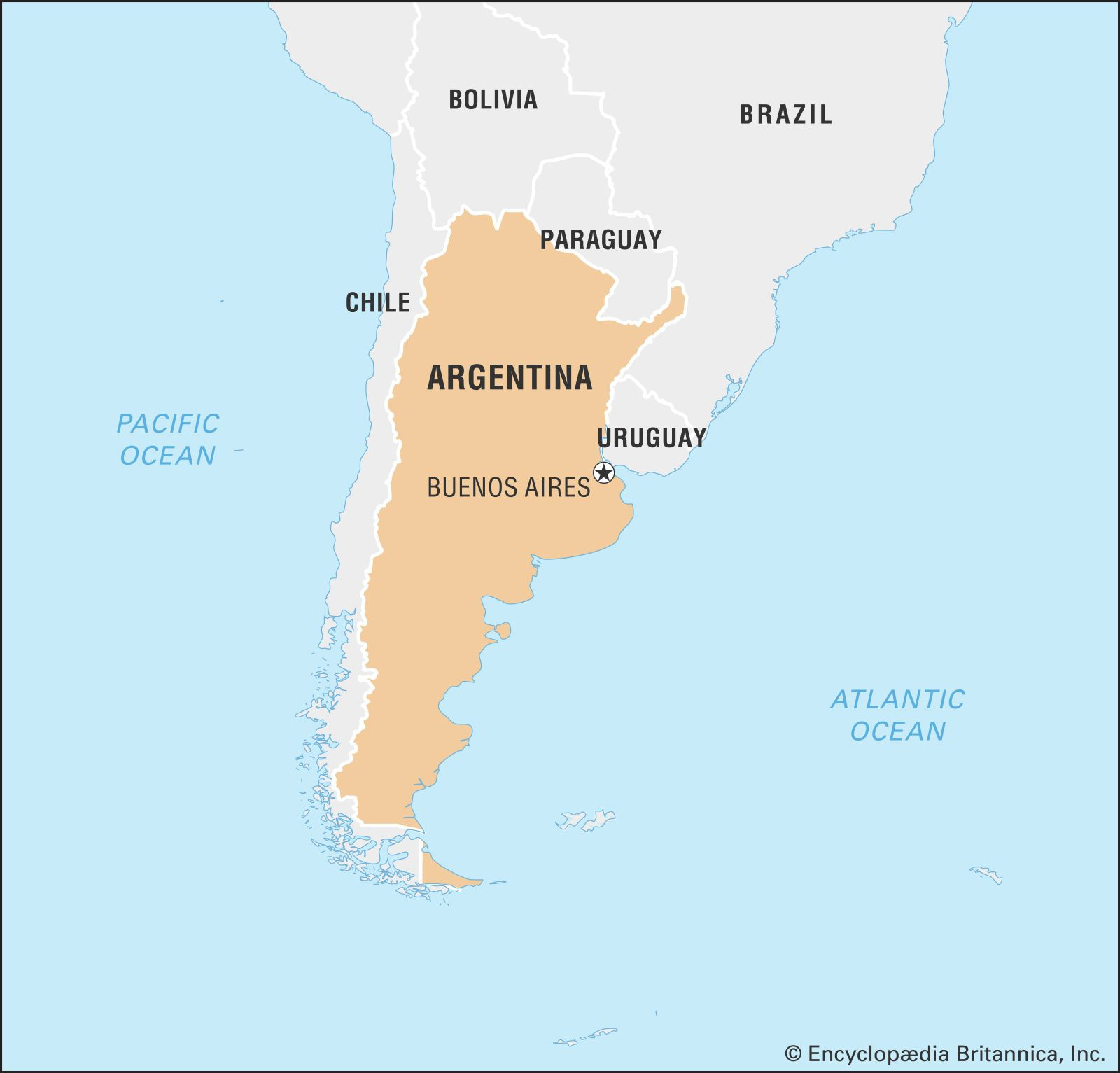 Argentina map location in South America
Argentina’s location in South America is clearly depicted on this locator map, showcasing its position relative to neighboring countries and the Atlantic Ocean.
Argentina’s Diverse Regions: A Land of Contrasts
Argentina’s expansive territory encompasses an astonishing variety of geographical regions, each with its own unique characteristics and contributing to the country’s overall diversity. From towering mountains to vast plains and icy glaciers, Argentina’s location blesses it with a remarkable range of landscapes.
The Andes Mountains: The Western Spine
Stretching along Argentina’s western border with Chile, the Andes Mountains form a formidable and breathtaking geographical feature. This region, known as the Andean region, is characterized by high peaks, deep valleys, and stunning glacial lakes. The Northwest Andes in Argentina feature high plateaus (punas) and basins, with elevations ranging from 10,000 to 13,400 feet. Here, you’ll find Mount Aconcagua, the highest peak in both the Western and Southern Hemispheres, reaching a staggering 22,831 feet. Further south, the Patagonian Andes offer a different kind of beauty, with dramatic peaks, extensive ice fields, and glaciers like the Perito Moreno, making it a popular destination for adventurers and nature lovers.
The Andes Mountains, seen here overlooking Lake Mascardi, define Argentina’s western landscape and offer stunning natural beauty.
The North: Chaco and Mesopotamia
Moving eastward from the Andes, Argentina’s northern region presents a stark contrast. The Gran Chaco, or simply Chaco, is a vast lowland plain characterized by dry conditions, thorny vegetation, and hot subtropical climate. It stretches across northern Argentina and into neighboring Paraguay. To the east of the Chaco lies Mesopotamia, a region aptly named “Between the Rivers” as it’s nestled between the Paraná and Uruguay rivers. This area features rolling hills, subtropical forests, and wetlands, contrasting sharply with the arid Chaco. The famous Iguazu Falls, a natural wonder shared with Brazil, are located in the northeastern part of Mesopotamia, showcasing the region’s dramatic waterways.
The Pampas: Argentina’s Fertile Heartlands
Central Argentina is dominated by the Pampas, expansive grasslands that have been the historical and economic heartland of the country. These fertile plains are renowned for their agricultural richness, supporting vast cattle ranches and grain production. The Pampas extend westward from the Atlantic coast and blend into the Chaco and Mesopotamia regions to the north. The eastern Pampas are more humid and fertile, while the western Pampas are drier, creating a gradient of agricultural potential across this vast region.
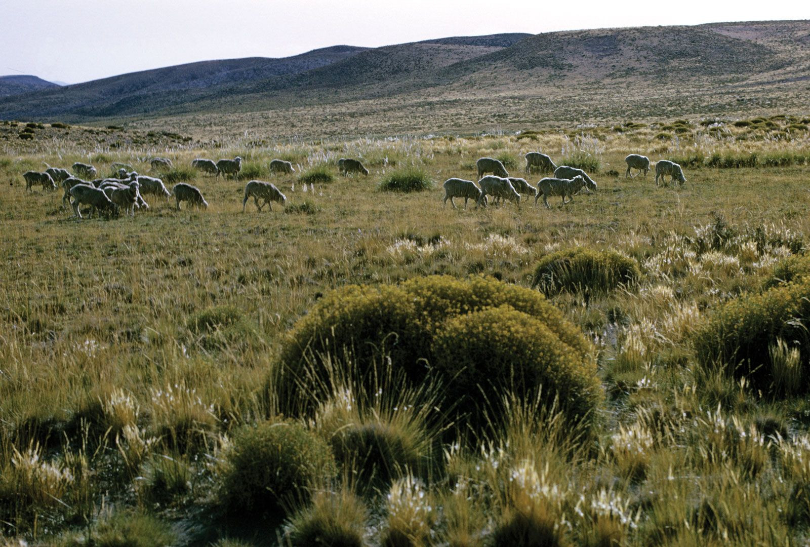 Sheep grazing in the Argentine Pampas
The Pampas grasslands, as seen here with grazing sheep, represent Argentina’s fertile heartland and agricultural wealth.
Patagonia: The Southern Frontier
Extending south from the Pampas to the tip of South America, Patagonia is a region of dramatic landscapes, characterized by vast plateaus, arid steppes, and the southern Andes. This sparsely populated region is known for its strong winds, cold climate, and unique wildlife. Patagonia’s eastern side features dramatic cliffs along the Atlantic coast, while the western side is dominated by the Andes and glacial landscapes. The region is a haven for adventure tourism, offering opportunities for hiking, trekking, and exploring glaciers like the Perito Moreno.
The Perito Moreno Glacier in Patagonia exemplifies the region’s stunning glacial landscapes and icy beauty.
Argentina’s Coastline and Maritime Claims: Facing the Atlantic
Argentina’s eastern boundary is defined by its extensive coastline along the Atlantic Ocean. This coastline stretches for approximately 2,900 miles, offering diverse coastal environments, from sandy beaches to dramatic cliffs. Major cities like Buenos Aires and Mar del Plata are located along this Atlantic coast, making it a vital region for trade, tourism, and population centers.
Atlantic Coast: A Varied Shoreline
Argentina’s Atlantic coastline varies significantly from north to south. The northern part features wider continental shelves and warmer waters, while the southern Patagonian coast becomes more rugged with colder waters and dramatic cliffs. This coastline is crucial for Argentina’s fishing industry and maritime activities, and its beaches are popular tourist destinations, especially during the summer months.
Antarctica and South Atlantic Islands: Extending Argentina’s Reach
Argentina also asserts claims to territories beyond its continental mainland. It claims a sector of Antarctica, overlapping with claims from Chile and the United Kingdom. Furthermore, Argentina disputes the UK’s sovereignty over the Falkland Islands (Islas Malvinas), as well as South Georgia and the South Sandwich Islands, located in the South Atlantic. These territorial claims highlight Argentina’s ambition to extend its geographical reach beyond mainland South America.
Key Cities and Their Locations: Urban Centers in a Vast Land
Despite its vast landscapes, Argentina is a largely urbanized country, with major cities concentrated in specific regions. Understanding the location of these cities provides further insight into Argentina’s geography and population distribution.
Buenos Aires: The Cosmopolitan Capital
Buenos Aires, the capital of Argentina, is located on the eastern coast of the country, on the Río de la Plata estuary which opens into the Atlantic Ocean. This bustling metropolis is the cultural, economic, and political heart of Argentina. Its location on the coast has made it a major port city and a gateway for immigration and international trade. Buenos Aires is known for its European-influenced architecture, vibrant nightlife, and rich cultural scene, often likened to major European capitals.
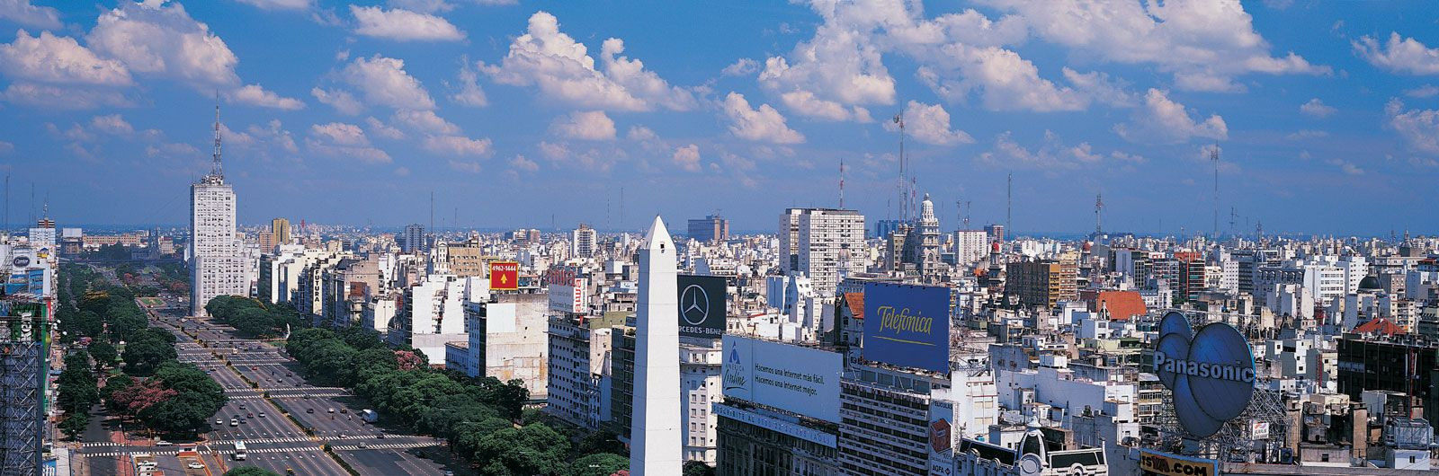 Buenos Aires, Argentina's Capital City
Buenos Aires, Argentina’s capital, is a sprawling metropolis located on the Atlantic coast, serving as the nation’s cultural and economic center.
Other Major Cities: Regional Hubs
Beyond Buenos Aires, Argentina has several other significant cities located in different regions of the country. Córdoba, Argentina’s second-largest city, is located in the interior, in the central part of the country, within the Pampas region but near the Sierras de Córdoba mountains. Rosario, another major city, is situated on the Paraná River, serving as a key river port and agricultural center. Mendoza, located in the western part of Argentina, near the Andes, is famous for its wine production and proximity to mountain tourism. Mar del Plata, south of Buenos Aires on the Atlantic coast, is a major beach resort city. These cities, distributed across Argentina’s diverse regions, serve as important regional hubs and reflect the country’s geographical spread and diverse economic activities.
Conclusion: A Country Defined by its Location
So, where is Argentina located? Argentina is located in the southern part of South America, occupying a significant portion of the continent’s southern cone. It is bordered by Bolivia and Paraguay to the north, Brazil and Uruguay to the east, Chile to the west, and the Atlantic Ocean to the east. This strategic location endows Argentina with an extraordinary geographical diversity, ranging from the Andes Mountains to the Pampas grasslands and the Patagonian wilderness. Understanding Argentina’s location is fundamental to appreciating its climate, landscapes, culture, and its role as a major player in South America and the global stage. From the bustling streets of Buenos Aires to the majestic peaks of the Andes and the vast plains of the Pampas, Argentina’s location is the foundation of its unique identity and captivating appeal.