
Malaysia, a vibrant and diverse nation, is strategically positioned in the heart of Southeast Asia. Understanding where Malaysia is located geographically is key to appreciating its unique cultural blend, rich history, and diverse ecosystems. This article delves into the precise location of Malaysia, exploring its regional context, geographical coordinates, and the distinct characteristics of its two major regions: Peninsular Malaysia and East Malaysia.
Geographical Coordinates and Regional Context
Malaysia is uniquely divided into two main regions by the South China Sea. Peninsular Malaysia, also known as West Malaysia, occupies the southern portion of the Malay Peninsula. It shares a land border with Thailand to the north, stretching approximately 300 miles (480 km). At the peninsula’s southern tip, connected by causeways and bridges, lies the island nation of Singapore. To the southwest, across the Strait of Malacca, is Sumatra, an island belonging to Indonesia. This location places Peninsular Malaysia at a crucial maritime crossroads, historically significant for trade and cultural exchange.
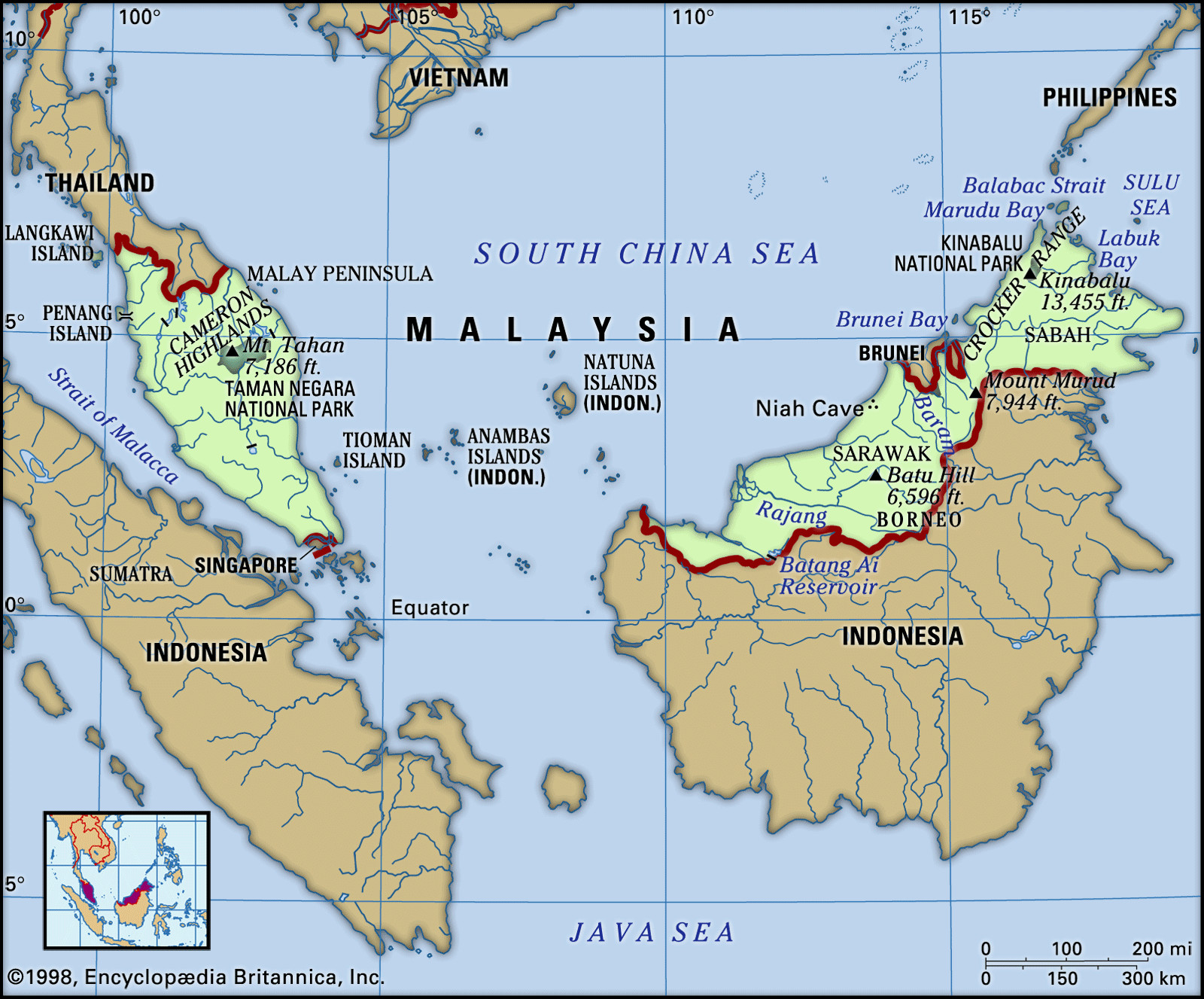 Map highlighting the location of Malaysia in Southeast Asia, showcasing Peninsular and East Malaysia and neighboring countries
East Malaysia, comprising the states of Sarawak and Sabah, is situated on the island of Borneo. It is separated from Peninsular Malaysia by about 400 miles (640 km) of the South China Sea. East Malaysia occupies the northern part of Borneo, sharing a land border with Kalimantan, the Indonesian part of the island, to the south. Enclaved within Sarawak is the independent sultanate of Brunei, adding another layer to the region’s complex geography. East Malaysia’s location on Borneo, the third-largest island in the world, contributes to its distinct biodiversity and geological landscape.
In terms of area, East Malaysia accounts for about 60 percent of Malaysia’s total landmass, while Peninsular Malaysia comprises roughly 40 percent. This geographical division contributes to the country’s diverse landscapes and ecosystems, influencing everything from climate to culture.
Topography and Terrain
The terrain of Malaysia is as varied as its cultural tapestry, significantly shaped by its location.
Peninsular Malaysia is characterized by a mountainous backbone running north to south. This rugged landscape is dominated by the Main Range, a mountain chain extending approximately 300 miles (480 km) with peaks rising over 7,000 feet (2,100 meters). Granite and other igneous rocks constitute about half of the peninsula’s geological composition. Distinctive karst formations, featuring limestone hills, caves, and subterranean passages, are prominent in the central and northern regions. Bordering this mountainous core are coastal lowlands, wider on the west coast (10 to 50 miles or 15 to 80 km) and narrower and more fragmented along the east coast.
East Malaysia, on the other hand, presents a different topographical profile. It features a long coastal plain, averaging 20 to 40 miles (30 to 60 km) wide in Sarawak and 10 to 20 miles (15 to 30 km) wide in Sabah due to its more indented coastline. Inland from the coast lies a region of hills and valleys, generally below 1,000 feet (300 meters), though some hills reach up to 2,500 feet (750 meters). Further inland, a mountainous spine forms the border with Kalimantan. This region is characterized by plateaus, ravines, and mountain ranges, with most peaks ranging between 4,000 and 7,000 feet (1,200 and 2,100 meters). Dominating this complex is Mount Kinabalu in Sabah, soaring to 13,435 feet (4,095 meters), the highest peak in Malaysia and the entire Southeast Asian archipelago.
Drainage and River Systems
Malaysia’s location within a tropical climate zone ensures abundant rainfall, which in turn shapes its extensive river systems.
Peninsular Malaysia is crisscrossed by a network of rivers and streams. The longest river, the Pahang, stretches 270 miles (434 km). These waterways experience consistent flow due to year-round rainfall, although water volume fluctuates with rainfall intensity. However, heavy rains can lead to floods, particularly in areas affected by mining and agriculture that disrupt natural river flow.
East Malaysia‘s drainage is also dictated by its interior highlands, which act as a watershed dividing Malaysia and Indonesia. A dense network of perennial rivers, sustained by constant rainfall, covers the region. The Rajang River in Sarawak, the longest in the state at approximately 350 miles (563 km), is navigable for a significant distance inland. Similarly, Sabah’s Kinabatangan River, while comparable in length, is navigable for a slightly shorter distance. Historically, these rivers have served as vital transportation and settlement arteries, connecting coastal areas to the interior.
Soil Composition and Characteristics
The tropical location of Malaysia influences its soil composition significantly. Both Peninsular and East Malaysia have soils that have undergone extensive tropical weathering. This process has leached out many plant nutrients, resulting in generally acidic, coarse-textured soils with low organic matter content. The rapid oxidation of organic matter further depletes soil fertility. Soil erosion is a constant concern, especially on slopes, necessitating conservation efforts like contour embankments and cover crops.
While most of Peninsular Malaysia has soils of limited fertility requiring regular fertilization for agriculture, Sabah in East Malaysia stands out with areas of more fertile soils, particularly in the southeastern coastal regions. These fertile soils are derived from basic volcanic materials, offering better agricultural potential compared to other parts of Malaysia.
In conclusion, understanding where Malaysia is located reveals a nation of geographical contrasts and richness. From the peninsula bridging mainland Southeast Asia to the island of Borneo, Malaysia’s diverse landscapes, shaped by its unique location, contribute to its ecological significance and cultural tapestry within the Southeast Asian region.