Syria, officially the Syrian Arab Republic, is a country in Western Asia. Understanding Where Is Syria Located is crucial to grasping its regional significance and diverse geographical features. Nestled in the heart of the Middle East, Syria’s location has historically been a crossroads of civilizations, influencing its culture, climate, and landscape.
Syria’s Strategic Location in the Middle East
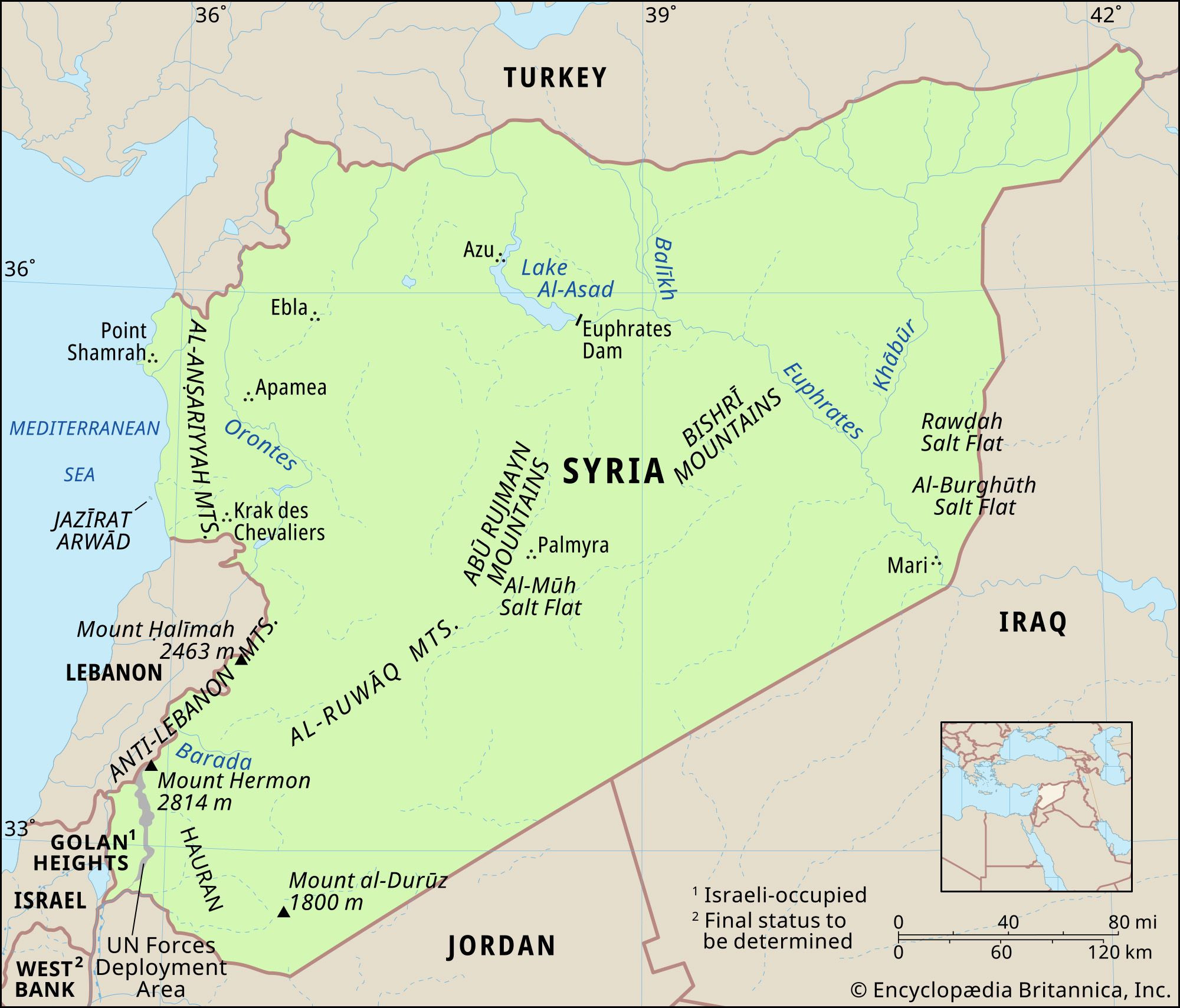
Syria is situated in the Levant region of the Eastern Mediterranean, often considered part of the Middle East. Its geographical coordinates place it at the meeting point of Asia, Europe, and Africa, giving it immense historical and strategic importance. To pinpoint where is Syria located more precisely, it is bordered by Turkey to the north, Iraq to the east and southeast, Jordan to the south, and Lebanon and Israel to the southwest. This placement makes Syria a vital land bridge connecting different parts of the region.
A detailed map illustrating the physical features of Syria and its location relative to neighboring countries like Turkey, Iraq, Jordan, Lebanon and Israel.
Diverse Topography: From Coastline to Desert
Syria’s landscape is surprisingly diverse, ranging from a Mediterranean coastline in the west to arid desert in the east. This variety in terrain is a defining aspect of where Syria is located and contributes to its ecological and agricultural diversity.
Coastal Plains and Mountain Ranges
In the west, Syria boasts a coastline stretching approximately 110 miles (180 km) along the Mediterranean Sea. This coastal strip, situated between Turkey and Lebanon, features sandy bays, rocky headlands, and low cliffs. Just inland from the coast, the Al-Anṣariyyah Mountains rise, running north to south and bordering the narrow coastal plain. These mountains, also known as the Nusayriyah Mountains or Alawite Mountains, average 20 miles (32 km) in width and gradually decrease in height from north to south, peaking at 5,125 feet (1,562 meters) east of Latakia.
Inland Depressions and Mountains
East of the Al-Anṣariyyah Mountains lies the Ghāb Depression, a significant 40-mile (64-km) long valley that cradles the Orontes River (Nahr Al-ʿĀṣī). Further east, marking Syria’s border with Lebanon, are the Anti-Lebanon Mountains (Jabal Al-Sharqī). This mountain range is more imposing, reaching a maximum height of 8,625 feet (2,629 meters) near Al-Nabk, with Mount Hermon (Jabal Al-Shaykh), Syria’s highest point, soaring to 9,232 feet (2,814 meters). Scattered throughout the country are smaller mountain ranges like Mount Al-Durūz in the south and the Abū Rujmayn and Bishrī Mountains in the central region.
The Syrian Desert and Inland Plains
The majority of Syria is characterized by undulating plains, part of the vast Syrian Desert (Badiyat al-Sham). These plains, generally lying between 980 and 1,640 feet (300 and 500 meters) above sea level, are not typical sand deserts but rather rock and gravel steppe. The southern-central part of this area is known as Al-Ḥamād, further contributing to the arid landscape that defines a significant portion of Syria’s location.
Rivers and Water Systems: Lifelines in an Arid Land
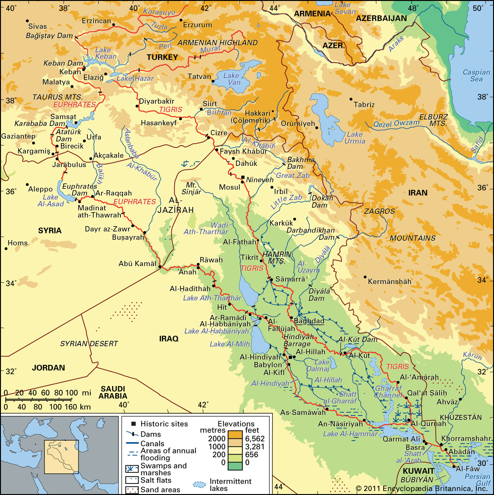
Water resources are vital in understanding where Syria is located, especially considering its largely arid climate. The Euphrates River stands as Syria’s most crucial water source and its only navigable river. Originating in Turkey, it flows southeast across eastern Syria, forming the backbone of agriculture and life in this region. The Euphrates Dam, creating Lake Al-Asad, is a significant water management project on this river.
 Tigris and Euphrates river basin
A geographical representation of the Tigris and Euphrates river basin, highlighting the crucial drainage network in the region and Syria’s position within it.
The Orontes River is another significant waterway, primarily in the mountainous western region. It flows north from Lebanon through the Ghāb Depression and into the Mediterranean Sea in Turkey. The Yarmouk River, a tributary of the Jordan River, drains the Jabal Al-Durūz and Hauran regions in the southwest, forming part of the border with Jordan.
Syria also features scattered lakes, the largest being Al-Jabbūl, a seasonal saline lake southeast of Aleppo. Other notable salt lakes include Jayrūd and Khātūniyyah. Lake Muzayrīb and Lake Qattinah (Lake Homs) provide freshwater resources in specific areas. Interestingly, much of Syria’s drainage is subterranean, with porous rocks allowing water to form underground springs and rivers, though these can be vulnerable to depletion and salinization.
Climate and Soil: Influenced by Location
Syria’s climate is largely dictated by its geographical location. The coast and western mountains experience a Mediterranean climate characterized by hot, dry summers and mild, wet winters. Inland, the climate transitions to arid, with greater temperature extremes between seasons. Precipitation is highest in the west, decreasing significantly eastward into the desert regions.
Soils across Syria vary, with the exception of fertile black soil in the northeastern Al-Jazīrah region, most soils are deficient in phosphorus and organic matter due to aridity. Common soil types include clays and loams, some calcareous and others containing gypsum, especially in the Euphrates valley. Alluvial soils are found in river valleys and the Ghāb Depression, supporting agriculture in these areas.
Conclusion: Syria’s Geography – A Land of Contrasts
Understanding where is Syria located reveals a country of geographical contrasts. From its Mediterranean coast to its inland mountains and vast deserts, and from fertile river valleys to arid plains, Syria’s diverse landscape is a product of its location at the crossroads of the Middle East. This geographical diversity has profoundly shaped Syria’s history, culture, and environment, making its location a key factor in understanding this complex nation.


