
Zimbabwe, a nation in Southern Africa, is a landlocked country known for its diverse landscapes, rich history, and vibrant culture. Understanding Where Is Zimbabwe geographically is key to appreciating its unique environment and regional significance. This article delves into the geographical location of Zimbabwe, exploring its key physical features, drainage systems, and geological characteristics that define this fascinating nation.
Geographic Location and Key Facts About Zimbabwe
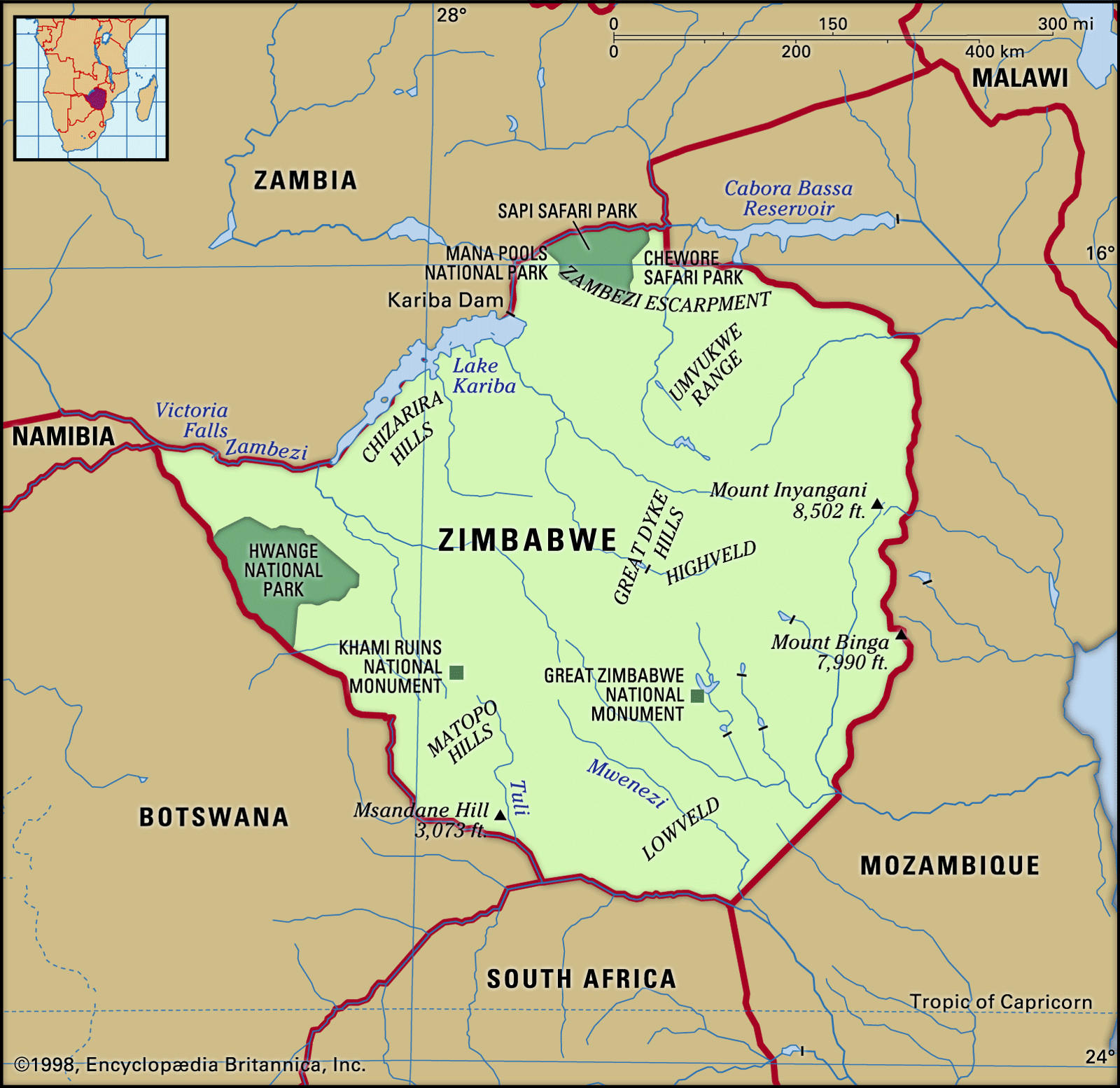
Zimbabwe is situated in Southern Africa, nestled between the Zambezi and Limpopo Rivers. It shares borders with Zambia to the north and northwest, Mozambique to the east and northeast, South Africa to the south, and Botswana to the southwest. Its location places it squarely within the subtropical zone, influencing its climate and vegetation.
 Zimbabwe Location Map
Zimbabwe’s geographical coordinates are approximately 20° South latitude and 30° East longitude. Being landlocked, Zimbabwe relies on its neighboring countries for access to the sea. Despite this, its central location in Southern Africa makes it a significant regional player. The capital city, Harare, is located in the northeastern part of the country, situated on the Highveld.
Diverse Topography: Highveld, Middleveld, and Lowveld Regions
Zimbabwe’s landscape is characterized by a prominent central ridge known as the Highveld, extending from the southwest to the northeast. This elevated spine is the country’s defining physical feature, influencing climate, drainage, and land use patterns. The country can be broadly divided into three main topographical regions: the Highveld, the Middleveld, and the Lowveld.
The Highveld Spine: Zimbabwe’s Elevated Heart
The Highveld forms the backbone of Zimbabwe, stretching approximately 400 miles across the nation. This ridge averages between 4,000 to 5,000 feet in altitude, culminating in Mount Inyangani, the highest peak in Zimbabwe at 8,504 feet. The Highveld region, constituting about 25% of Zimbabwe, is known for its cooler temperatures and serves as the watershed divide for the country’s major river systems.
The Expansive Middleveld: Plateaus Descending from the Highveld
Flanking the Highveld on both sides are the plateaus of the Middleveld. These regions slope downwards from the central ridge towards the Zambezi River in the north and the Limpopo River in the south. The Middleveld, situated between 3,000 and 4,000 feet above sea level, makes up a significant portion of Zimbabwe, approximately 40% of its total area. This region is characterized by gently rolling hills and is vital for agriculture.
The Lower Reaches of the Lowveld: Zimbabwe’s Arid Zones
The Lowveld occupies the lower altitudes of Zimbabwe, primarily in the south and southeast. This region lies below 3,000 feet and is characterized by its warmer, drier climate and more arid landscapes. The Lowveld, constituting about 23% of Zimbabwe, is drained by rivers like the Sabi, Lundi, and Nuanetsi flowing into the Limpopo. While parts of the Lowveld are severely arid, it is also home to unique ecosystems and wildlife.
Drainage Systems and River Basins of Zimbabwe
Zimbabwe’s drainage system is dominated by three major river systems: the Zambezi, Limpopo, and Sabi. The Highveld ridge acts as the primary watershed, directing water either northwards towards the Zambezi or southwards towards the Limpopo and Sabi. These rivers are crucial for water resources, agriculture, and ecosystems in Zimbabwe and the wider region.
The Zambezi River, forming the northern border with Zambia, is a major river in Africa and is dammed to create Lake Kariba, one of the world’s largest man-made lakes. The Limpopo River marks the southern border with South Africa and Mozambique, while the Sabi River flows primarily through eastern Zimbabwe. These river systems ultimately drain into the Indian Ocean via Mozambique.
Unique Geological Features Shaping Zimbabwe’s Terrain
Zimbabwe’s landscape is sculpted by ancient geological formations, predominantly Precambrian rock, dating back millions of years. Granite is the dominant rock type, forming iconic features like the Matopo Hills and balancing rocks. The Great Dyke, a unique geological structure, bisects the country and holds significant mineral wealth.
Ancient Precambrian Rock and Granite Formations in Zimbabwe
The basement complex, composed largely of granite, underlies much of Zimbabwe. Erosion of granite batholiths has created striking landscapes like the Matopo Hills, south of Bulawayo. These hills are characterized by whaleback rock formations and balancing rocks, sculpted by wind and water over millennia. Kopjes, small rounded granite hillocks, are also a common feature across the Zimbabwean landscape.
The Great Dyke and Karoo System: Geological Wonders
The Great Dyke is an extraordinary geological feature, a massive linear intrusion of mafic and ultramafic rocks stretching for about 330 miles across Zimbabwe. It is renowned for its rich mineral deposits, including chromium, nickel, and platinum. The Karoo System, sedimentary rock formations, covers regions like the Zambezi valley and parts of the Lowveld, adding to the geological diversity of Zimbabwe.
Conclusion: Zimbabwe’s Distinctive Geographical Identity
In conclusion, where is Zimbabwe is not just a matter of coordinates, but an exploration of a land with diverse topography, significant river systems, and ancient geological formations. From the elevated Highveld to the arid Lowveld, and from the Zambezi to the Limpopo, Zimbabwe’s geography shapes its environment, economy, and the lives of its people. Understanding its location and physical features is crucial to appreciating the unique character of this Southern African nation.