Greece, officially known as the Hellenic Republic, is a captivating country celebrated for its rich history, stunning landscapes, and vibrant culture. But Where Is Greece Country exactly? Understanding the geographical location of Greece is key to appreciating its unique character and influence. This article will delve into the precise location of Greece, exploring its continental position, borders, and surrounding seas, providing a comprehensive understanding of where this fascinating country sits on the world map.
Geographical Location of Greece
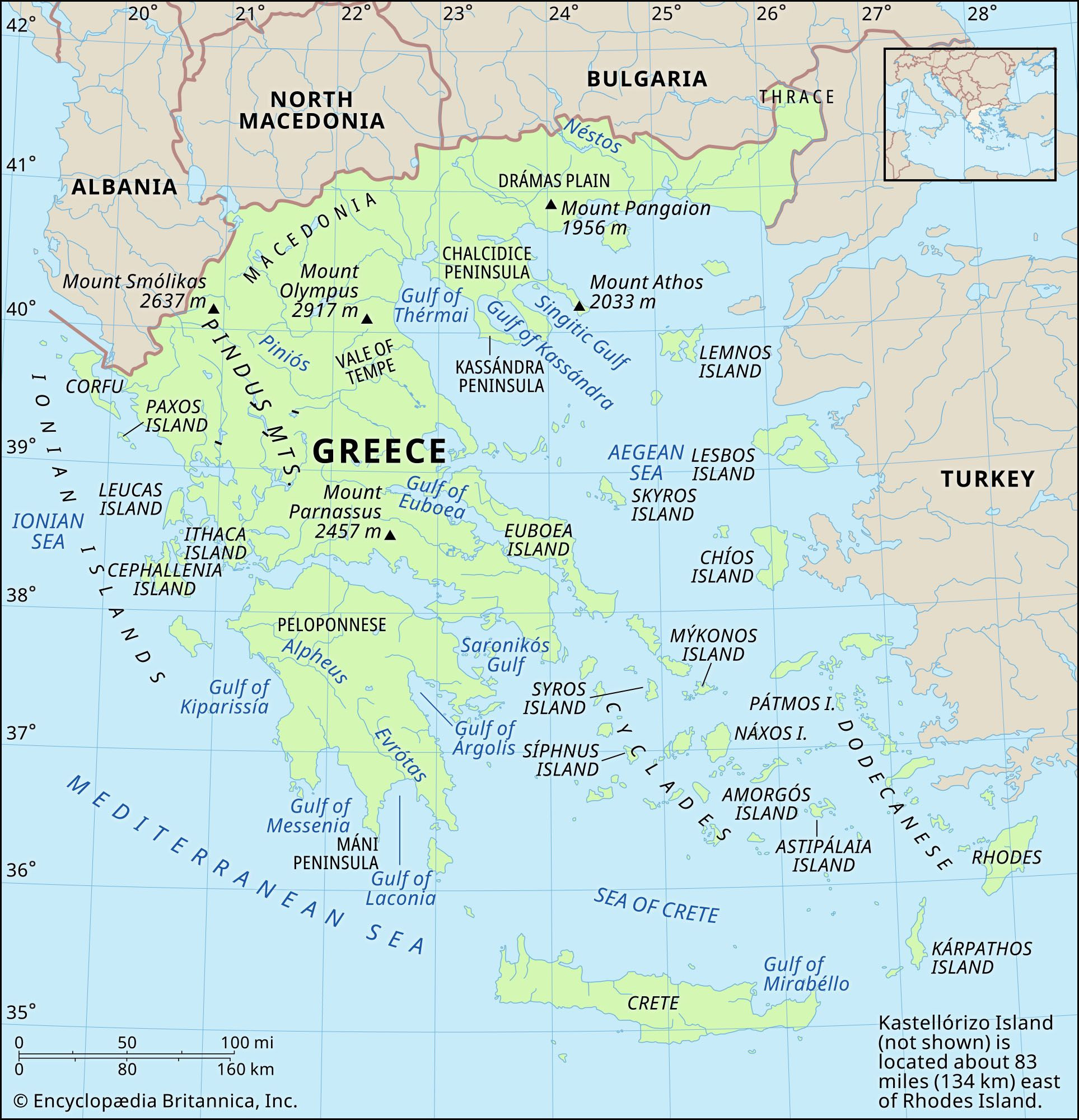
Greece is situated in Southern Europe, specifically at the southernmost tip of the Balkan Peninsula. This strategic location places it at the crossroads of Europe, Asia, and Africa, contributing to its historical significance and cultural diversity. Its mainland is connected to the European continent to the north, while its peninsular and island formations extend into the Mediterranean Sea.
Continental Location: Europe, Balkans, Mediterranean
Greece is undeniably a European country, both geographically and culturally. It forms the southern extremity of the Balkan Peninsula, a region known for its mountainous terrain and diverse history. Moreover, Greece is a Mediterranean country, deeply intertwined with the Mediterranean Sea, which has shaped its climate, economy, and way of life for millennia. This Mediterranean identity is crucial to understanding Greek culture and its historical connections to other Mediterranean civilizations.
Bordering Countries
Greece shares land borders with four countries:
- Albania: To the northwest, marking the beginning of Greece’s northern land boundary.
- North Macedonia: To the north, further defining Greece’s northern frontier in the central Balkan region.
- Bulgaria: To the northeast, completing the majority of Greece’s land border on the eastern Balkan side.
- Turkey: To the east, separated by the Maritsa River in Thrace, marking the southeastern land border and the proximity to Asia Minor.
These land borders are significant, but it’s the maritime borders that truly define Greece’s geography.
Maritime Borders: Aegean, Mediterranean, Ionian Seas
The sea is integral to Greece’s identity. It is surrounded by three major bodies of water:
- Aegean Sea: To the east, separating Greece from Turkey and dotted with numerous Greek islands. The Aegean has been historically vital for Greek trade and culture.
- Mediterranean Sea: To the south, the vast expanse of water that has connected civilizations for centuries. Greece’s southern coastline is entirely on the Mediterranean.
- Ionian Sea: To the west, bordering the western coast of Greece and separating it from Italy. The Ionian Islands are a distinct group within Greece, known for their lush landscapes.
 Physical features of Greece
Greek Islands
A defining feature of Greece is its extensive archipelago. It boasts over 2,000 islands, with approximately 170 inhabited. These islands constitute about one-fifth of Greece’s total land area and are spread across the Aegean and Ionian Seas. Notable island groups include:
- Cyclades: Famous for their iconic white-washed villages and located in the central Aegean Sea (e.g., Santorini, Mykonos).
- Dodecanese: Situated in the southeastern Aegean, closer to Turkey (e.g., Rhodes, Kos).
- Ionian Islands: Located off the western coast of Greece in the Ionian Sea (e.g., Corfu, Zakynthos).
- Crete: The largest Greek island, located south of the Peloponnese in the Mediterranean Sea.
These islands are not just geographically significant; they are vital to Greek tourism, culture, and biodiversity.
Understanding Greece’s Unique Geography
Greece’s geography is characterized by its rugged, mountainous terrain and extensive coastline. These features have profoundly influenced its development.
Mountainous Terrain
Mountains dominate approximately four-fifths of Greece, creating natural divisions and historically limiting inland communication. The Pindus Mountains form the spine of mainland Greece, running from north to south and impacting climate and accessibility. These mountains have contributed to regionalism within Greece but also provided natural defenses throughout history.
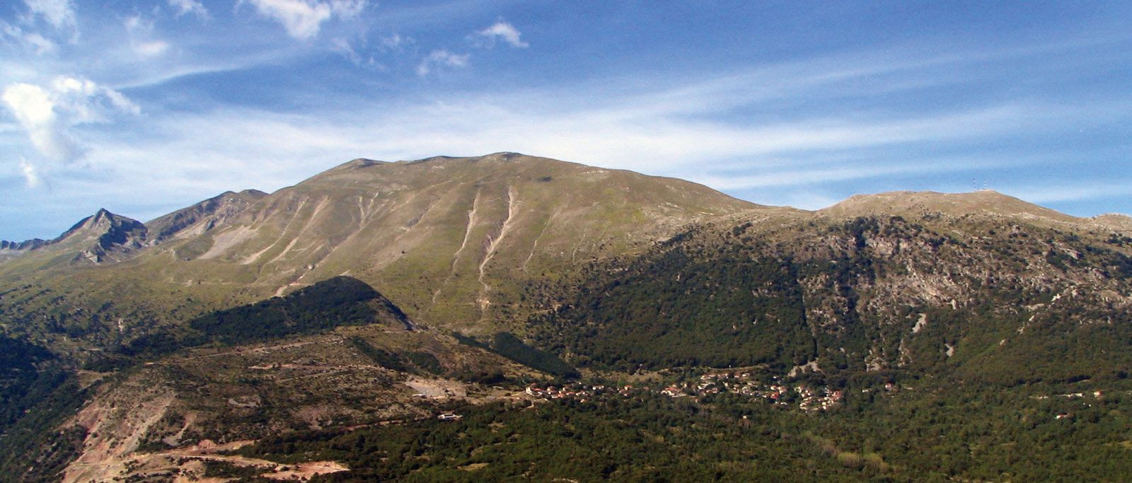 Pindus Mountains
Coastline and Islands
The highly indented coastline and numerous islands are perhaps the most recognizable aspects of Greek geography. No point in mainland Greece is more than 50 miles from the sea. This proximity to the sea has fostered a maritime culture, with seafaring, trade, and fishing playing crucial roles in Greek history and economy. The islands, in particular, offer diverse landscapes, from volcanic Santorini to verdant Corfu, attracting visitors from around the globe.
Regional Divisions
Greece can be broadly divided into several geographical regions, each with unique characteristics:
- Central Greece: Home to the Pindus Mountains and fertile basins.
- Northeastern Greece (Makedonía and Thráki): Characterized by plains and river valleys, bordering North Macedonia and Bulgaria.
- Eastern Greece: Includes Attica, the region around Athens, and Euboea, the second-largest Greek island.
- Southern Greece (Peloponnese): A peninsula connected to the mainland by the Isthmus of Corinth, rich in history and ancient sites.
- Western Greece: Facing the Ionian Sea, known for its coastal plains and the Ionian Islands.
- The Islands: Divided into various groups as mentioned earlier, each with distinct geological and cultural identities.
Greece in the World Context
Greece’s location has been historically and remains strategically important.
Historical Significance of its Location
Throughout history, Greece’s position has made it a crucial crossroads. Ancient Greece was a maritime power, with its location facilitating trade and cultural exchange between Europe, Asia, and Africa. It was the cradle of Western civilization, and its geographical position allowed for the dissemination of Greek culture and ideas throughout the Mediterranean and beyond. Later, the Byzantine Empire, centered in Constantinople (modern-day Istanbul, Turkey, near Greece), continued this tradition of being a bridge between East and West.
Modern Geopolitical Importance
In modern times, Greece’s location remains significant within the European Union and NATO. It is a gateway to Europe from the Middle East and North Africa. Its control over key sea lanes in the Mediterranean and Aegean Seas is vital for trade and security. Furthermore, Greece’s position within the Balkans makes it a key player in regional stability and development.
Conclusion
So, where is Greece country? Greece is strategically located in Southern Europe, at the southern tip of the Balkan Peninsula, bordering Albania, North Macedonia, Bulgaria, and Turkey. It is surrounded by the Aegean, Mediterranean, and Ionian Seas and includes thousands of islands. This unique geographical position has shaped its history, culture, and continues to influence its role in the modern world. Understanding Greece’s location is the first step in appreciating the depth and richness of this remarkable country. Its blend of European, Balkan, and Mediterranean characteristics makes it a truly unique and fascinating place to explore.