
When examining the global pattern of earthquake occurrences, a clear picture emerges: seismic activity is far from random. Instead, it clusters into distinct earthquake belts, notably circling the Pacific Ocean and tracing the mid-Atlantic Ridge. Remarkably, over 80% of the world’s major earthquakes strike around the Pacific Ocean’s rim, a zone famously known as the “Ring of Fire.” This fiery belt marks where the Pacific plate dives beneath the surrounding tectonic plates in a process called subduction. The Ring of Fire stands as the most seismically and volcanically dynamic region on our planet.
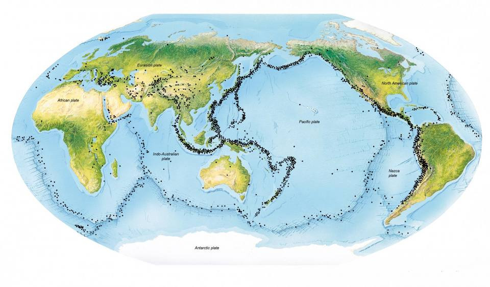 Global distribution of earthquakes showing concentration along tectonic plate boundaries like the Ring of Fire.
The Earth’s crust beneath us is riddled with faults, legacies of its tumultuous geological history. Geologists can map some of these faults at the surface, while others remain hidden kilometers underground. These fault lines are the key locations where earthquakes are most likely to occur. Stress building up within the Earth’s tectonic plates is eventually released through movement along these faults, generating seismic waves that we experience as earthquakes.
Explore Recent Earthquake Activity:
For those interested in real-time earthquake data, the British Geological Survey (BGS) provides regularly updated feeds:
- Earthquakes around the British Isles (last 50 days)
- Induced seismicity around the British Isles (last 50 days)
- Significant world earthquakes (last 200 days)
- Online data feeds (GeoRSS & KML)
Earthquakes in the UK: Seismic Activity Closer to Home
Despite its distance from major plate boundaries like the Mid-Atlantic Ridge, the UK experiences its own share of earthquakes. These occur as stresses within the Earth’s crust are relieved by movements along pre-existing fault planes. While less frequent and generally less intense than those in the Ring of Fire, UK earthquakes are a notable geological phenomenon.
The precise causes of earthquake activity in the UK are still under investigation. Contributing factors are believed to include regional compression from the movement of tectonic plates and the ongoing uplift of the landmass following the melting of ice sheets from the last ice age.
The BGS detects and locates between 200 and 300 earthquakes in the UK annually. Of these, approximately 20 to 30 are felt by people, while sensitive instruments record hundreds of smaller tremors. The vast majority are minor and cause no damage. However, historical records show that some British earthquakes have been significant enough to cause considerable damage, although not on the scale of major global seismic events.
On average, a magnitude 4 earthquake occurs in Britain roughly every two years. Magnitude 5 earthquakes are less frequent, occurring approximately every 10–20 years. Current research suggests that the maximum possible earthquake magnitude in the UK is around 6.5.
The BGS plays a crucial role in assessing earthquake hazards for various engineering projects in the UK. This expertise informs construction methods and operational procedures for large-scale infrastructure projects, such as the Channel Tunnel and new power stations, ensuring resilience to potential seismic activity.
Regional Variations in UK Earthquake Distribution
Examining a map of earthquake activity across the British Isles reveals distinct regional patterns. The majority of UK earthquakes are concentrated on the western side of the mainland. In contrast, eastern Scotland and north-east England experience very little seismic activity. Similarly, Ireland is notably seismically quiet. Interestingly, the North Sea exhibits higher earthquake activity compared to the mainland UK.
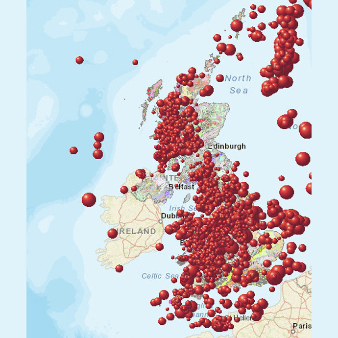 Earthquake frequency across the British Isles, highlighting higher seismic activity in western regions from 2000 to 2020.
Notable UK Earthquakes in History
The largest recorded earthquake in Britain occurred in 1931 near the Dogger Bank, reaching a magnitude of 6.1. Its offshore location, approximately 60 miles from the coast, mitigated potential damage, although minor damage to buildings was still reported along the east coast of England. The most destructive UK earthquake in historical records struck the Colchester area in 1884. This event caused damage to around 1200 buildings, with reports of collapsed chimneys and cracked walls, highlighting the potential impact of even moderate earthquakes in populated areas.
(Source: British Geological Survey – BGS ©UKRI. All rights reserved.)