
Malta, a captivating island nation steeped in history and boasting stunning landscapes, is situated in a strategically important location. But Where Is Malta Located exactly? This archipelago, a jewel in the Mediterranean Sea, holds a position that has shaped its culture, climate, and character for millennia. Comprising five islands, with Malta being the largest, alongside Gozo, Comino, and the uninhabited Kemmunett (Comminotto) and Filfla, this country is geographically positioned in the heart of the Mediterranean, offering a bridge between Europe and Africa.
Geographical Location and Archipelago Composition
Malta’s precise location places it south of Sicily, north of Libya, and east of Tunisia. To be more specific, it lies approximately 58 miles (93 kilometers) south of Sicily, 180 miles (290 kilometers) north of Libya, and roughly 180 miles (290 kilometers) east of Tunisia. This positioning situates Malta at the eastern end of the Mediterranean’s narrowest point, effectively separating Italy from the African coast. This central Mediterranean location has historically made Malta a crucial maritime crossroads and a point of cultural exchange.
Topography and Relief of Malta
The Maltese islands are characterized by their distinctive limestone geology. The landscape is largely defined by limestone formations, contributing to coastlines marked by dramatic cliffs, picturesque bays, and secluded coves. These islands are part of the submerged Malta-Hyblean Platform, an underwater bridge connecting Sicily’s Ragusa Platform to Libya’s Tripolitana Platform.
The island of Malta itself is bisected by a prominent escarpment known as the Victoria Lines Fault. This fault line runs across the island, from Point ir-Raħeb near Fomm ir-Riħ Bay to the northeast coast near Għargħur at Madliena Fort, shaping the island’s topography. The highest elevations are found in the coralline limestone uplands, forming a triangular plateau. Ta’ Żuta, reaching 830 feet (253 meters) in the southwest, marks the highest point on the island. These uplands transition into blue clay slopes in the surrounding areas, with an undercliff zone where the coralline plateau descends to form a secondary surface between the sea and the original coastline. Malta’s total shoreline extends for approximately 136 miles (219 kilometers).
In northern Malta, the escarpment presents an occasionally abrupt and fragmented landscape, punctuated by deep inlets. Moving south, the plateau gradually slopes from approximately 600 to 830 feet (180 to 250 meters) into undulating terrain composed of globigerina limestone, which is less than 300 feet (90 meters) above sea level. The western region is notable for its deeply carved valleys and undercliff areas, while the eastern part features several valley systems that lead to the central plains.
Coastal Features and Harbors
Malta’s western coast is characterized by a high, imposing, and generally harborless facade. In contrast, the eastern coast offers more accessible harbors. A notable feature of the east coast is Mount Sceberras, a high ridge where Valletta, Malta’s capital city, is located. This ridge effectively separates Marsamxett Harbour and the iconic Grand Harbour. Due to historical tectonic activity, Malta has tilted slightly northward. This geological movement has resulted in towering cliffs, reaching up to 800 feet (250 meters) in height, along the south and southwestern coasts. Conversely, the northern and eastern coasts gently slope down to lower cliffs and rocky shores.
Gozo Island: Landscape and Topography
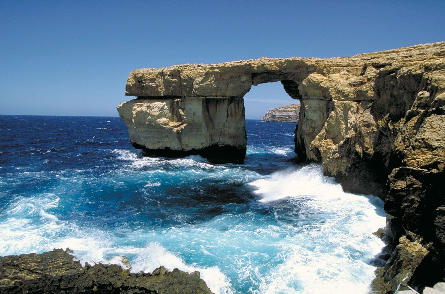
Gozo, the second largest island in the Maltese archipelago, presents a landscape distinguished by broken upper coralline mesas. The highest point on Gozo is Ta’ Dbiegi Hill, reaching 636 feet (194 meters). Gozo exhibits a gentle easterly slope, causing the lower coralline limestone, which forms high cliffs on the west coast, to descend below sea level, only to reappear on the east coast at Qala Point. Semicircular bays have formed along the coastal cliffs where sinkholes have been eroded by the sea. Examples of these include the rounded bays at Xlendi and Dwejra on Gozo’s west coast, which originated as underground caverns with roofs that subsequently collapsed. While the Azure Window at Dwejra, featured in many iconic images of Gozo, unfortunately collapsed in 2017 due to natural erosion, the area remains a testament to Gozo’s unique coastal geomorphology.
 Gozo island, Malta: Azure Window
Drainage and Water Resources
Malta’s geological structure provides favorable conditions for water percolation and underground storage. The impermeable blue clay layers create two distinct water tables within the limestone formations: the perched and the mean sea-level aquifer. For centuries, the primary source of public water supply has been the main sea-level water table. However, the absence of permanent rivers or lakes and significant runoff into the sea have historically presented challenges for water supply. To address this, Malta has implemented an extensive reverse-osmosis desalination program. Currently, desalination plants across the islands supply approximately half of Malta’s daily water requirements.
Soil Composition and Characteristics
Maltese soils are generally young, immature, and thin. They typically lack humus, and their high carbonate content results in alkaline properties. Human activity and construction have modified the distribution and composition of soils across the islands. Recognizing the importance of soil preservation, the Fertile Soil (Preservation) Act of 1973 mandates that soils removed from construction sites must be transported to agricultural areas. Additionally, level areas within quarries are often covered with transported soil to enhance agricultural potential.
In conclusion, Malta’s location in the central Mediterranean Sea, coupled with its unique geological composition and topography, defines its character. From its limestone cliffs and harbors to its limited freshwater resources and efforts at soil conservation, Malta’s geography is inextricably linked to its history and present-day realities.