Suriname, officially known as the Republic of Suriname, is a captivating country situated on the northern coast of South America. Often overlooked in favor of its larger neighbors, Suriname boasts a unique blend of cultural diversity, rich history, and stunning natural landscapes. For those wondering, Where Is Suriname located?, this article will delve into the geographical coordinates and fascinating characteristics that define this South American nation.
Discovering Suriname: Location and Key Geographical Facts
Suriname is nestled in the northeastern corner of South America, within the region often referred to as the Guianas. To pinpoint where Suriname is on the map, consider its borders:
- North: Atlantic Ocean
- East: French Guiana
- South: Brazil
- West: Guyana
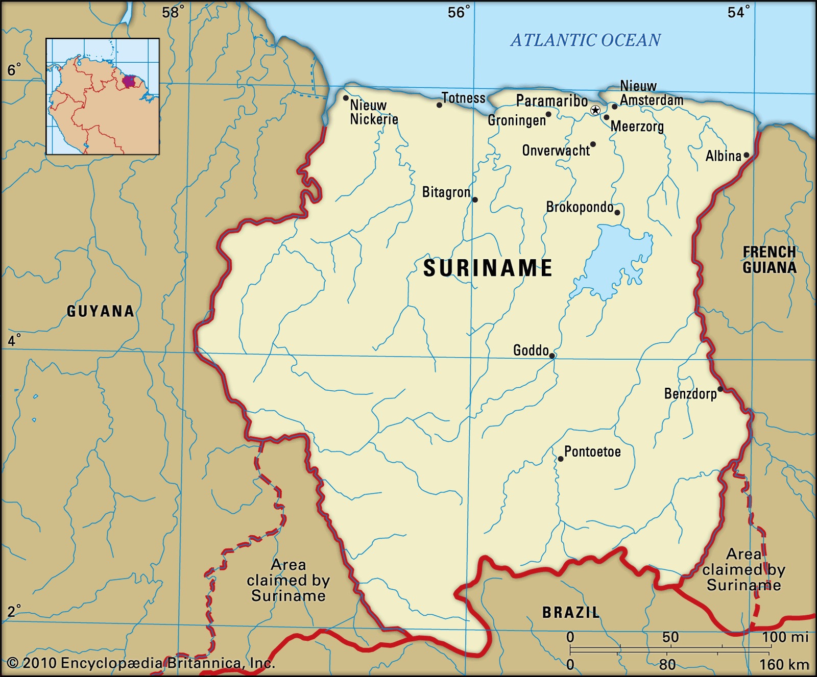 Suriname map highlighting its location in South America
This strategic location places Suriname in a geographically significant area, bridging the Caribbean region with the heart of South America. Paramaribo, the vibrant capital city, is conveniently situated just 9 miles (15 km) inland from the Atlantic coast, along the banks of the Suriname River.
Suriname’s geographical coordinates are approximately 4°N latitude and 56°W longitude. This equatorial proximity blesses the country with a tropical climate, fostering lush rainforests and diverse ecosystems. Despite being one of the smallest countries in South America, covering an area of 63,251 square miles (163,820 square km), Suriname’s geographical diversity is remarkable.
A Glimpse into Suriname’s Diverse Terrain
The landscape of Suriname is a tapestry of contrasting environments, shaped by its location and geological history. From the Atlantic coastline to the depths of the Amazon rainforest, Suriname offers a rich array of natural wonders.
Coastal Plains and Fertile Lands
The northernmost region of Suriname is characterized by a narrow coastal plain stretching approximately 226 miles (364 km). This area is composed of sand and mud deposits carried by equatorial currents from the Amazon River basin. Further inland, the New Coastal Plain emerges, a region of swampland covering about 6,600 square miles (17,000 square km). These reclaimed lands, known as polders, are particularly fertile and crucial for agriculture.
Inland Highlands and Rainforests
Moving southward, the terrain transitions to older coastal plains and then to the Zanderij formation, a landscape of rolling hills characterized by quartz-rich, bleached sands. Beyond this, the heart of Suriname is dominated by a central mountain range and its sprawling branches, enveloped by a vast tropical rainforest. This rainforest, part of the larger Amazon basin, constitutes nearly four-fifths of the country’s total area, making Suriname one of the most forested countries in the world. Juliana Top, the nation’s highest peak at 4,035 feet (1,230 metres), stands within the Wilhelmina Mountains in this region.
Rivers and Drainage
Suriname’s geography is also defined by its network of rivers, all flowing northward into the Atlantic Ocean. Major rivers include the Courantyne River, marking the border with Guyana; the Coppename River; the Suriname River, upon which the capital city is situated; and the Maroni River, forming the boundary with French Guiana. These rivers are vital for transportation, irrigation, and the country’s ecosystem.
Understanding Suriname’s Climate and Biodiversity
Located near the equator, Suriname experiences a tropical climate characterized by warm temperatures and high rainfall throughout the year. The northern, populated areas typically have four distinct seasons, including two rainy and two dry periods. Rainfall is abundant, especially in the central and southeastern regions, contributing to the dense rainforest ecosystems.
This climate nurtures exceptional biodiversity. Suriname is home to thousands of plant species, including valuable timber trees and unique flora in its vast rainforests. The country also boasts a rich fauna, with diverse species of mammals, reptiles, birds, and fish. Notably, the Central Suriname Nature Reserve, a UNESCO World Heritage site, protects a massive area of pristine rainforest, showcasing Suriname’s commitment to preserving its natural heritage.
Suriname in the Context of South America and the World
While geographically part of South America, Suriname’s history and cultural connections are unique. Formerly known as Dutch Guiana, Suriname gained independence from the Netherlands in 1975. Dutch remains the official language, setting it apart from its Spanish and Portuguese-speaking South American neighbors. This Dutch colonial past, combined with influences from indigenous cultures, African, Indian, and Javanese populations, has shaped Suriname into one of the most ethnically diverse countries in the Americas.
In conclusion, Suriname’s location in northeastern South America defines its climate, geography, and biodiversity. From its Atlantic coastline to its Amazonian interior, Suriname offers a fascinating blend of landscapes and ecosystems. Understanding where Suriname is geographically provides a foundation for appreciating its unique cultural identity and its significant role within the South American continent.