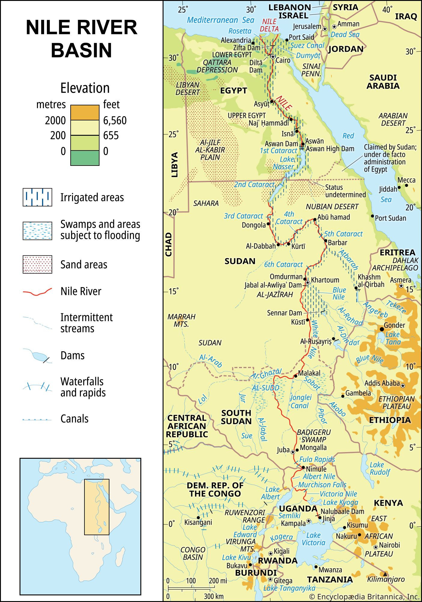
The Nile River, often celebrated as the longest river in the world and affectionately known as the “father of African rivers,” is a geographical marvel that has nurtured civilizations for millennia. Its location is central to understanding its historical and ecological significance. Originating south of the Equator, this majestic river embarks on a northward journey through northeastern Africa before emptying into the Mediterranean Sea. Spanning approximately 4,132 miles (6,650 kilometers), the Nile River’s expansive basin covers an estimated 1,293,000 square miles (3,349,000 square kilometers).
This vast river basin encompasses parts of numerous countries, highlighting the Nile’s widespread influence across the African continent. These nations include Tanzania, Burundi, Rwanda, the Democratic Republic of the Congo, Kenya, Uganda, South Sudan, Ethiopia, Sudan, and the fertile regions of Egypt. Notably, its most remote source can be traced back to the Kagera River in Burundi, underscoring the river’s extensive reach into the heart of Africa.
 Nile River basin and its drainage network showing countries and water flow
The Confluence of Rivers: Formation of the Nile
The Nile River is not a single stream but rather the result of the convergence of three primary tributaries, each contributing to its grandeur. These are the Blue Nile (originating from the Ethiopian Highlands), the Atbara River (also from the Ethiopian Highlands), and the White Nile. The White Nile’s headwaters begin their journey in the Lake Victoria and Lake Albert region, adding to the complex network that forms this iconic river system.
A River of Many Names: Tracing its History
The name “Nile” has linguistic roots in the Greek word “Neilos” (Latin: Nilus), likely derived from the Semitic root “naḥal“, signifying a valley or river valley, and by extension, a river. Intriguingly, unlike other major rivers known to ancient civilizations, the Nile’s northward flow and annual flooding during the warmest months puzzled the ancient Egyptians and Greeks alike. The ancient Egyptians called the river “Ar” or “Aur” (Coptic: Iaro), meaning “Black,” a reference to the dark sediments carried by the river during flood season. This dark Nile mud was so distinctive it lent the land its oldest name, Kem or Kemi, also meaning “black” and symbolizing darkness. In Homer’s epic poem, the Odyssey, “Aigyptos” refers to both the Nile River (masculine) and the country of Egypt (feminine) through which it flows, showcasing the river’s inseparable link to the land. Today, in Egypt and Sudan, the Nile is known as Al-Nīl, Al-Baḥr, and Baḥr Al-Nīl or Nahr Al-Nīl.
The Nile Basin: Cradle of Ancient Civilizations
The Nile River basin, encompassing approximately one-tenth of the African continent, served as the backdrop for the rise and fall of advanced ancient civilizations. The fertile banks of the Nile were home to people who pioneered agriculture and the use of the plow. Geographically, the basin is bordered by the Mediterranean Sea to the north, the Red Sea Hills and Ethiopian Plateau to the east, the East African Highlands (including Lake Victoria) to the south, and the watershed between the Nile, Chad, and Congo basins, extending to the Libyan Desert and Marrah Mountains, to the west.
The consistent water supply from the Nile throughout the year, coupled with the region’s warm climate, has facilitated intensive agriculture along its course. Even in areas with sufficient average rainfall, the unpredictable nature of annual precipitation often necessitates irrigation, making the Nile’s waters indispensable for cultivation.
The Nile’s Enduring Importance
Beyond agriculture, the Nile River has historically been a crucial transportation artery, especially during flood seasons when land transport was challenging. While advancements in air, rail, and road infrastructure in the 20th century have lessened reliance on river transport, the Nile remains a vital geographical and historical landmark, its location deeply intertwined with the story of Africa and human civilization.