
The Pacific Ocean, a vast expanse of saltwater, dominates the Earth’s surface, holding the title of the largest and deepest of the world’s oceanic divisions. Understanding its location is fundamental to grasping global geography and the interconnectedness of our planet. This comprehensive guide will explore the precise location of the Pacific Ocean, its boundaries, key characteristics, and its significant regional divisions.
Defining the Pacific Ocean’s Location and Boundaries
The Pacific Ocean is geographically positioned between the continents of Asia and Australia to the west, and North and South America to the east. It stretches latitudinally from the Arctic region in the north to the Antarctic region in the south, covering an astounding one-third of the Earth’s total surface area.
To be more specific, the Pacific Ocean extends from approximately 60° South latitude up to the Bering Strait, which connects it with the Arctic Ocean. This vast north-south stretch covers over 135 degrees of latitude, equating to roughly 9,600 miles (15,500 km). In terms of longitudinal extent, it spans nearly halfway around the globe, reaching its widest point around latitude 5° N, measuring approximately 12,000 miles (19,000 km) between Colombia in South America and the Malay Peninsula in Asia.
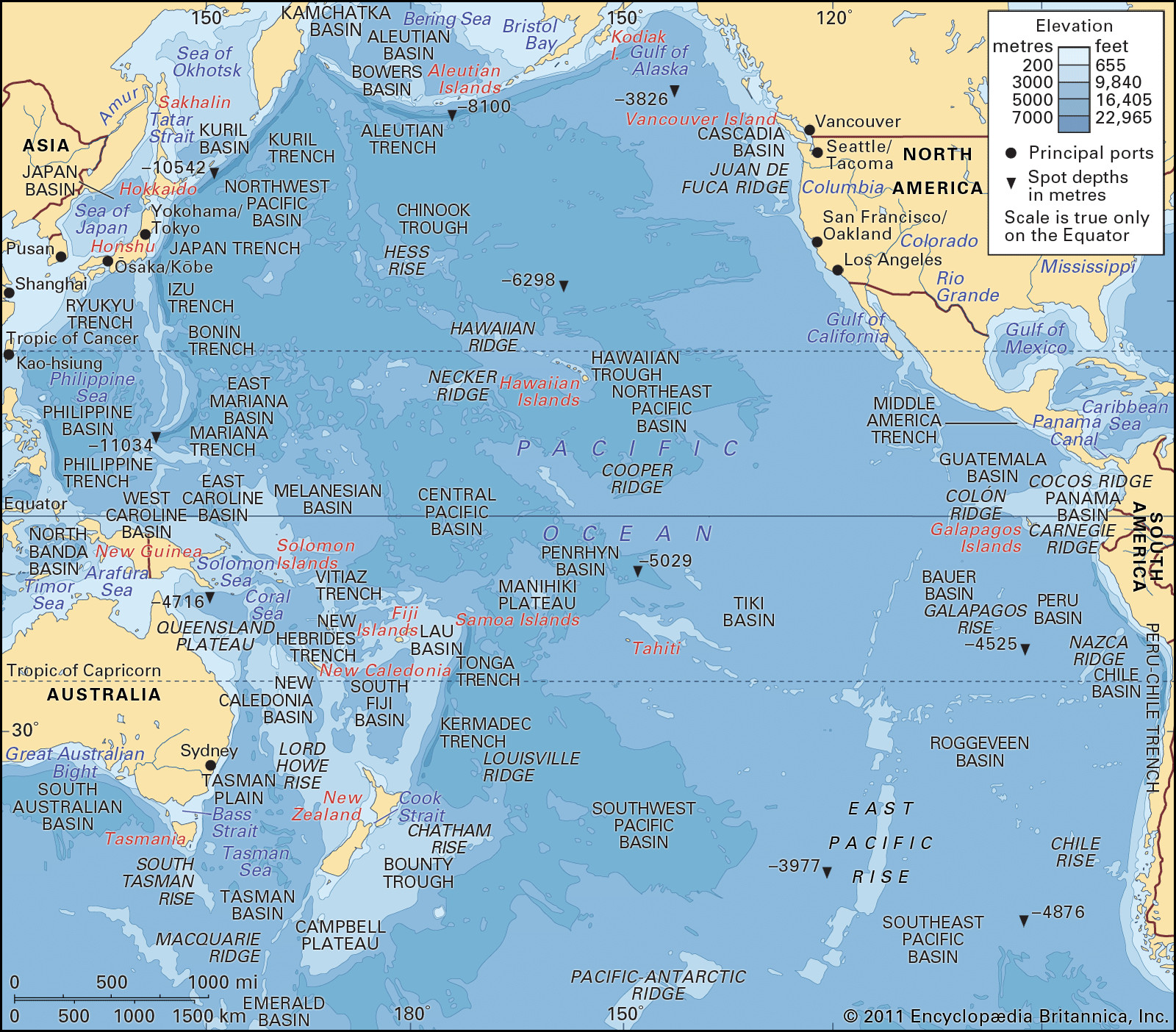 The Pacific Ocean, with depth contours and submarine features
Bordering Continents and Other Oceans
The Pacific Ocean is bordered by several major continents and connects with other significant bodies of water:
- Eastern Boundary: North and South America form the eastern boundary of the Pacific Ocean, running along their western coastlines from Alaska to Tierra del Fuego.
- Western Boundary: Asia and Australia define the western edge, encompassing the eastern coasts of Asia and the northern and eastern coasts of Australia.
- Northern Boundary: The Bering Strait acts as a crucial link to the Arctic Ocean in the north.
- Southern Boundary: In the south, the Pacific Ocean merges with the Southern Ocean around the 60° S parallel. The Drake Passage, situated between South America and Antarctica, also connects the Pacific with the Atlantic Ocean.
- Indian Ocean Boundary: The separation from the Indian Ocean is less defined but generally follows a line from Sumatra through Java and Timor, across the Timor Sea to Australia, and then south of Australia across the Bass Strait to Tasmania and finally to 60° S latitude.
Key Geographical Features of the Pacific Ocean
Beyond its location, the Pacific Ocean is characterized by several distinctive geographical features:
- Size and Depth: As the largest ocean, the Pacific covers an area of about 62.5 million square miles (161.76 million square km), excluding the South China Sea. It is larger than all the landmasses on Earth combined. The average depth is around 14,040 feet (4,280 meters).
- Mariana Trench: Home to the Mariana Trench, the deepest point on Earth, reaching a staggering depth of 36,201 feet (11,034 meters). This trench is located in the western North Pacific and is a result of tectonic plate subduction.
- Ring of Fire: The Pacific Ocean is encircled by the “Ring of Fire,” a major area in the basin of the Pacific Ocean where many earthquakes and volcanic eruptions occur. This is directly linked to the movement and collision of tectonic plates.
- Marginal Seas: The western Pacific is characterized by numerous marginal seas, including the Bering Sea, Sea of Okhotsk, Sea of Japan, Yellow Sea, East China Sea, and South China Sea. These seas are partially enclosed by peninsulas and island arcs.
Regional Divisions of the Pacific Ocean
For geographical and oceanographic studies, the Pacific Ocean is often divided into three primary regions based on their physiography:
Eastern Pacific Region
The Eastern Pacific region stretches from Alaska to Tierra del Fuego along the western coasts of the Americas. It is characterized by:
- Narrow Continental Shelf: A relatively narrow continental shelf runs parallel to the coastline.
- Steep Continental Slope: The continental slope adjacent to the shelf is very steep, descending rapidly into the deep ocean.
- Mountainous Coastline: The coastline is dominated by the American Cordillera mountain range, which rises sharply from the Pacific shores.
- Oceanic Trenches: Significant trenches in this region include the Middle America Trench in the North Pacific and the Peru-Chile Trench in the South Pacific, formed by the subduction of the Nazca Plate under the South American Plate and the Cocos Plate under the North American Plate.
The mountainous coastline of the eastern Pacific Ocean at Big Sur, California, showcasing the steep terrain meeting the ocean.
Western Pacific Region
The Western Pacific region extends along the eastern coasts of Asia and Australia. It is known for:
- Complex Structure: A more complex structure compared to the eastern region, marked by numerous island arcs, peninsulas, and marginal seas.
- Oceanic Trenches: A series of oceanic trenches define its seaward boundary, including the Aleutian, Kuril, Japan, Tonga, and Kermadec trenches. These are formed by the subduction of the Pacific Plate under the continental plates of Asia and Australia.
- Island Arcs and Marginal Seas: Features festoons of islands and peninsulas that enclose wide and deep continental seas. These island chains are the upper parts of vast underwater mountain systems.
Cape Irō on the Izu Peninsula, Japan, exemplifying the rugged coastline and island formations typical of the western Pacific.
Central Pacific Region
The Central Pacific region lies between the eastern and western regions and is the largest and most stable geologically:
- Vast Abyssal Plains: Characterized by expansive areas of low relief and abyssal plains, generally at a depth of about 15,000 feet (4,600 meters).
- Ridges and Basins: Features several ridges and basins, although the relief is less pronounced than in the western Pacific. Notable features include the Cocos Ridge, Sala y Gómez Ridge, East Pacific Rise, and Hawaiian Ridge.
- Geological Stability: Considered the most geologically stable structural province of the Earth’s crust.
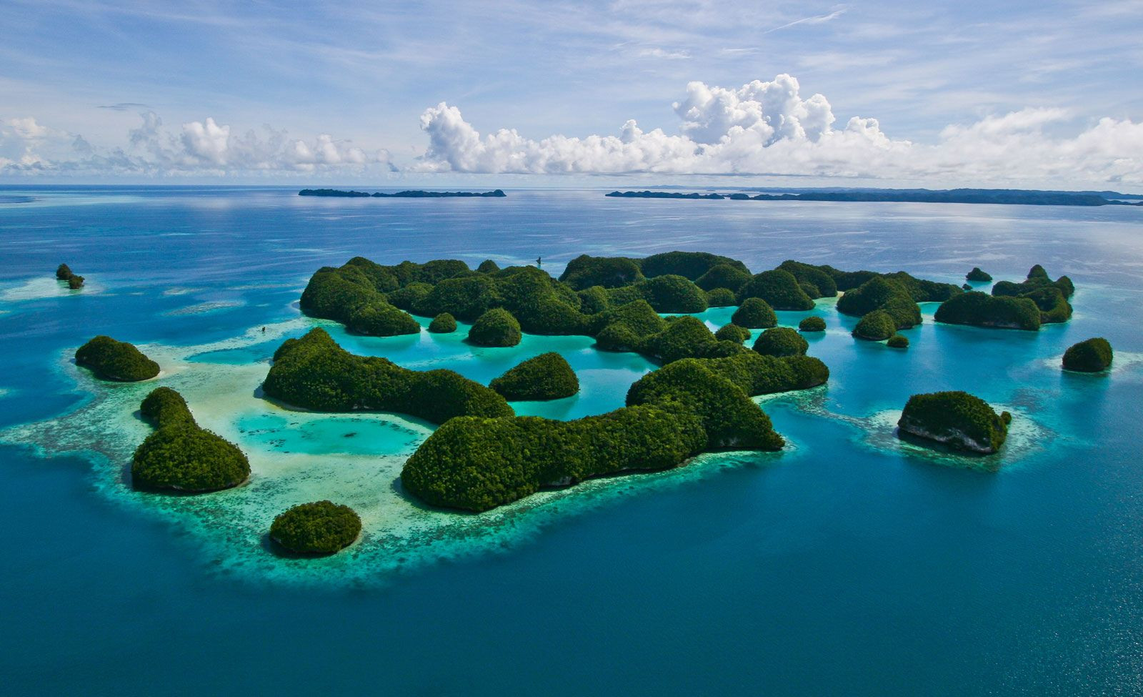 Palau: rock islands
The Significance of the Pacific Ocean’s Location
The location of the Pacific Ocean is crucial for several reasons:
- Climate Regulation: Its immense size plays a vital role in global climate patterns, influencing weather systems, ocean currents, and temperature distribution worldwide.
- Biodiversity Hotspot: The diverse environments within the Pacific, from deep trenches to coral reefs, support an extraordinary range of marine life, making it a biodiversity hotspot.
- Economic Importance: It is a major route for international shipping, a source of fisheries, and increasingly important for deep-sea mining and resource extraction.
- Geopolitical Significance: The Pacific region is home to numerous island nations and coastal countries, making it a region of significant geopolitical interest and cooperation.
Conclusion: A World Defined by the Pacific
Understanding “Where Is The Pacific Ocean Located” goes beyond simply pinpointing it on a map. It involves recognizing its vast scale, its critical role in Earth’s systems, and its profound impact on global geography, climate, and life itself. From the deepest trenches to the highest waves, the Pacific Ocean remains a dominant feature of our planet, shaping continents and connecting cultures across its expansive waters. Its location at the heart of the global map underscores its central importance in the story of our world.