Damascus, a city with roots stretching back to the 2nd millennium BCE, has long been a vital commercial hub, evolving through various stages of urbanization. Its historical significance reached its peak in the early 7th century CE when it became the capital of the vast Umayyad Empire. The heart of Damascus, often referred to as the Old City, is a treasure trove of historical monuments, with its origins tracing back to the Hellenistic period, significantly enhanced and modified during Roman rule.
 Umayyad Mosque in Damascus, Syria: A Key Landmark in the City's Historical Layout
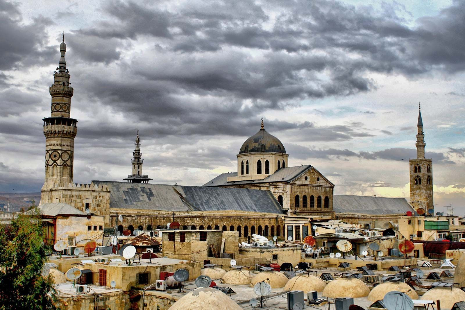
This Old City is roughly oblong-shaped, approximately 5,000 feet (1,500 meters) in length and 3,300 feet (1,000 meters) in width, defined by ancient walls, substantial portions of which still stand, particularly to the north and west. Historically, eight gates punctuated these walls, seven of which were originally built in the Classical style. The city’s main axis runs between Bāb al-Jābiyya, formerly the Roman Jupiter Gate in the west, and Bāb Sharqī, the Roman Sun Gate in the east. This axis follows the path of the ancient decumanus maximus, the principal east-west thoroughfare of the Roman city, now located about 15 feet (5 meters) beneath the modern street level. Interestingly, the cardo maximus, the main north-south street, has yet to be definitively located. Many of the secondary streets and prominent landmarks within the Old City owe their positioning to the meticulous Roman city planners of the 2nd and 3rd centuries CE.
However, the original orthogonal plan of the city experienced changes during the later Byzantine era in the 6th and 7th centuries. When the Umayyads established Damascus as their capital from 661–750, they did not drastically alter the existing city layout or significantly expand beyond its established walls. Despite a period of neglect and population decline between the 8th and 11th centuries, Damascus experienced a resurgence by the 13th century, growing beyond its old boundaries. This expansion occurred primarily along two axes extending outwards from the city walls. One axis connected Damascus northwestward to Ṣālḥiyyah, a suburb established in the 12th century by Jerusalem immigrants on the slopes of Mount Qasioun. The second axis formed a long, narrow stretch southward along the road leading towards Ḥawrān and Palestine. Recognizing its profound historical and cultural importance, the Old City of Damascus was designated a UNESCO World Heritage site in 1979.
The modern transformation of Damascus began during the Ottoman Tanzimat (Reorganization) period in the late 19th century. New buildings in European-inspired styles were constructed along newly laid straight streets to the west and north of the walled city, as well as in Al-Mujāhirīn, a new district for immigrants on Mount Qasioun. Later urban development followed a plan initially conceived by the French during the mandate period (1920–46), undergoing several revisions over time. Key features of this plan include wide boulevards radiating from squares around the Old City, particularly to the west and northwest, and later to the east. Modern housing predominantly consists of concrete apartment blocks lining these boulevards. Government buildings are mainly concentrated in an area west of the Old City, around Marjah Square, along Nasr Street, and in districts west of Ṣālḥiyyah Street.
Attracted by modern housing and amenities, wealthier families began moving to areas northwest of the Old City in the 1930s. This shift left their grand courtyard houses within the Old City to be occupied by lower-income tenants, often recent arrivals from rural areas, or repurposed for light industry. As the city’s population expanded, more and more gardens and agricultural land were converted into residential areas, many of which were informal settlements. Mukhalafāt, or informal districts, such as upper Al-Muhājirīn and the Kurdish quarter, grew further up the slopes of Mount Qasioun. Ancient nearby farming villages, including Al-Mazzah, Barzah, Kafr Sūsah, Al-Qābūn, and Al-Qadam, were gradually incorporated into the expanding city, both administratively and geographically. Government efforts to preserve green spaces and regulate housing and industry have faced significant challenges due to overwhelming population growth, administrative inefficiencies, and corruption. The development of affluent residential suburbs in the 1990s introduced valuable new parks and gardens to the north, northwest, and southeast of the city. Despite these additions, Damascus has lost over half of its green space since 1945, highlighting the ongoing pressures of urbanization on this ancient and historically significant city.