Malaysia, a vibrant nation in Southeast Asia, often sparks curiosity about its precise location. Understanding where Malaysia is situated geographically is key to appreciating its diverse landscapes, rich culture, and strategic importance. This article delves into the geographical details of Malaysia, providing a comprehensive overview of its location, terrain, and natural features.
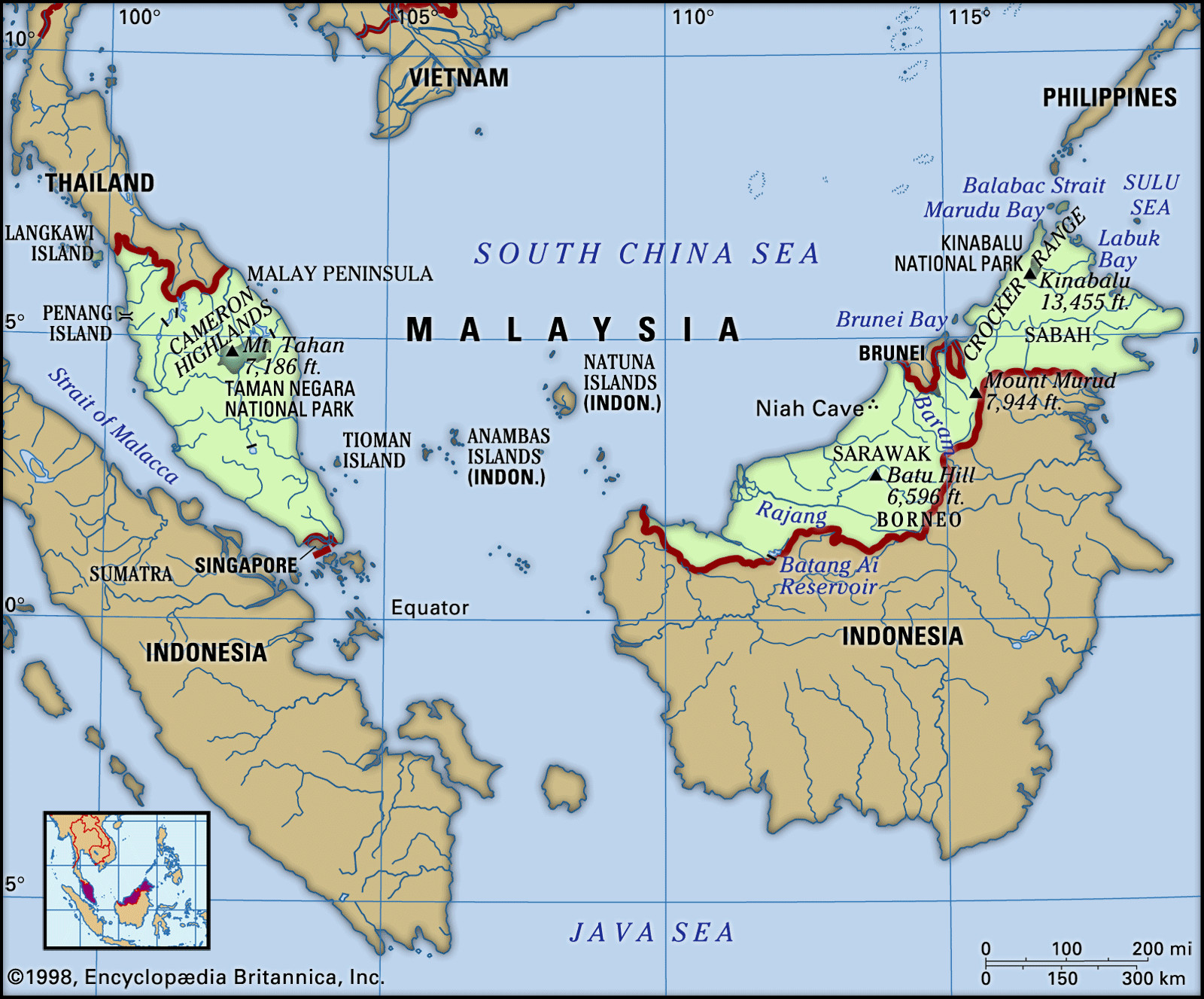
Malaysia is uniquely divided into two major regions: Peninsular Malaysia and East Malaysia. Peninsular Malaysia occupies the southern part of the Malay Peninsula, bordering Thailand to the north. To its south, across a causeway and bridge, lies the island nation of Singapore. The Strait of Malacca separates Peninsular Malaysia from the Indonesian island of Sumatra to the southwest.
East Malaysia, conversely, is located on the island of Borneo, approximately 400 miles (640 km) across the South China Sea from Peninsular Malaysia. It comprises the states of Sarawak and Sabah, occupying the northern portion of Borneo and sharing a land border with Kalimantan, the Indonesian part of the island, to the south. Within Sarawak lies Brunei, a small independent sultanate. Geographically, Peninsular Malaysia accounts for about 40% of the country’s total land area, while East Malaysia makes up the remaining 60%.
 Map of Malaysia highlighting its location and key geographical features
Diverse Terrain: Mountains, Plains, and Coasts
The landscape of Malaysia is remarkably varied, characterized by mountainous interiors and coastal plains. Peninsular Malaysia is defined by its mountainous backbone, running roughly north to south. This core is dominated by ranges like the Main Range, stretching for about 300 miles (480 km) and featuring peaks exceeding 7,000 feet (2,100 meters). Central and northern Peninsular Malaysia are also notable for karst topography, showcasing limestone hills, caves, and underground waterways. Flanking these mountains are coastal lowlands, wider on the west coast (10 to 50 miles or 15 to 80 km) and narrower, more fragmented on the east.
East Malaysia presents a different yet equally compelling terrain. It extends as an elongated landmass with a long coastline of 1,400 miles (2,250 km) bordering Kalimantan for 900 miles (1,450 km). The topography generally progresses from flat coastal plains inland to a hill and valley region, and finally to mountainous highlands forming the divide with Kalimantan. While the coastal plains in Sarawak average 20 to 40 miles (30 to 60 km) wide, Sabah’s rugged coastline narrows them to 10 to 20 miles (15 to 30 km). The hill and valley regions feature irregular terrain with elevations generally below 1,000 feet (300 meters), interspersed with hills reaching up to 2,500 feet (750 meters). The mountainous backbone of East Malaysia is a complex of plateaus, ravines, and ranges, with most peaks between 4,000 and 7,000 feet (1,200 and 2,100 meters). Dominating this complex is Mount Kinabalu, soaring to 13,435 feet (4,095 meters), the highest point in Malaysia and the entire Southeast Asian archipelago.
Rivers and Drainage Systems
Malaysia is rich in water resources, characterized by intricate river systems that play a vital role in the environment and human settlements. Both Peninsular and East Malaysia experience consistent rainfall, resulting in perennial rivers and streams. However, water volume can fluctuate significantly due to the torrential nature of tropical rainfall. Flooding is a recurring concern, particularly in areas where river systems have been disrupted by human activities like mining and agriculture.
In Peninsular Malaysia, the river network is dense, with the longest river, the Pahang, extending for 270 miles (434 km). East Malaysia’s drainage pattern is similarly defined by its highlands, which also serve as the watershed between Malaysia and Indonesia. The rivers here form a dense network, essential for transportation and historically, for settlement. The Rajang River in Sarawak, approximately 350 miles (563 km) long, is navigable for about 150 miles (240 km) inland. The Kinabatangan River in Sabah, of comparable length, is navigable for around 120 miles (190 km). These rivers have historically been crucial communication arteries, with settlements largely concentrated along their banks.
Soil Composition and Characteristics
The soils across Malaysia share common characteristics due to prolonged tropical weathering. This intense weathering has leached out many plant nutrients, resulting in soils that are typically acidic, coarse-textured, and low in organic matter. Organic matter decomposes rapidly in this climate, further depleting soil fertility. Soil erosion is a significant concern, especially on slopes, necessitating conservation measures like contour embankments and cover crops.
Fertile soils are limited in Peninsular Malaysia, requiring consistent fertilization for sustainable agriculture. Soil conditions in Sarawak and Sabah are generally similar, although Sabah stands out with more substantial areas of fertile soils, particularly in the southeastern coastal regions. These fertile areas owe their richness to parent materials derived from basic volcanic substances.
 Britannica logo representing access to further knowledge
Conclusion
Understanding where Malaysia is located geographically reveals a nation of diverse landscapes, from the mountainous peninsula to the island of Borneo. Its strategic position in Southeast Asia, coupled with its varied terrain, river systems, and soil conditions, shapes its environment, economy, and culture. From the towering Mount Kinabalu to the extensive river networks and fertile coastal plains of Sabah, Malaysia’s geography is as captivating as it is crucial to understanding this dynamic country.