
St. Thomas, a gem in the Caribbean, is a sought-after destination for travelers worldwide. If you’re wondering, “where is St. Thomas located?”, you’re in the right place. This island paradise is part of the U.S. Virgin Islands, nestled within the breathtaking Caribbean archipelago. To truly understand its location, let’s explore the broader geographical context of the Virgin Islands.
Discovering the Caribbean Context: Locating the Virgin Islands
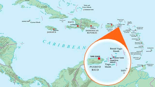
The Virgin Islands are situated within the Caribbean region, an expansive arc of islands that gracefully curves from the coast of Florida down towards South America. This vast region is a mosaic of hundreds of islands and cays, each with its unique charm and character. Geographically, the Caribbean is often divided into two main groups: the Greater Antilles and the Lesser Antilles.
 Caribbean Map
The Greater Antilles encompass the larger islands in the northwestern part of the Caribbean, including Cuba, Jamaica, the Cayman Islands, Hispaniola (shared by Haiti and the Dominican Republic), and Puerto Rico. Moving eastward and southward, we encounter the Lesser Antilles. This extensive group includes a multitude of smaller islands, stretching from the Virgin Islands in the north, through the Leeward Islands, and down to the Windward Islands and the islands just north of Venezuela. St. Thomas, as part of the Virgin Islands, falls within the northern section of the Lesser Antilles.
Pinpointing the Virgin Islands: USVI and BVI
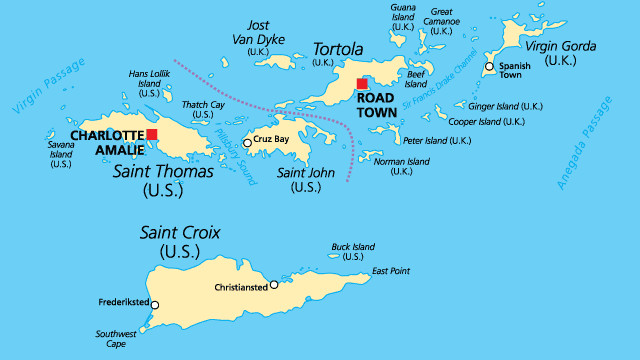
Within the Lesser Antilles, the Virgin Islands themselves are a distinct archipelago. A key point to note is that the Virgin Islands are politically divided between two entities: the United States and the United Kingdom. This division results in the United States Virgin Islands (USVI) and the British Virgin Islands (BVI).
 Virgin Islands Map
The US Virgin Islands, where St. Thomas is located, are positioned approximately 40-50 miles east of Puerto Rico. For those traveling from the mainland United States, St. Thomas is roughly 1106 miles southeast of Miami, Florida. The British Virgin Islands are situated just to the northeast of the US Virgin Islands, forming a close-knit island cluster.
St. Thomas within the US Virgin Islands Archipelago
The US Virgin Islands are composed of four principal islands: St. Croix, St. Thomas, St. John, and Water Island, along with approximately 50 smaller islets and cays. St. Thomas is renowned for its bustling capital, Charlotte Amalie, a historic harbor, and a dramatic hilly terrain that culminates in Crown Mountain, the island’s highest point at 1,556 feet. While largely hilly, downtown Charlotte Amalie presents a flatter landscape, making it easily walkable and explorable. St. Thomas, covering just over 31 square miles, is thirteen miles long and four miles wide.
Geographic Context of St. Thomas Compared to other USVI Islands
To further contextualize St. Thomas’s location, it’s helpful to understand its relation to the other USVI islands. St. Croix, the largest of the USVIs at 84 square miles, lies about 40 miles to the south of St. Thomas. St. John, famous for its pristine natural beauty and National Park, is located just 4 miles east of St. Thomas. Water Island, the smallest inhabited USVI, is a mere half-mile off the south coast of St. Thomas.
In conclusion, St. Thomas is geographically located in the US Virgin Islands, which are part of the northern Lesser Antilles in the Caribbean Sea, east of Puerto Rico and southeast of Florida. Its specific location within this island chain makes it a convenient and stunning Caribbean destination.