The Appalachian Trail (A.T.) is more than just a hiking path; it’s an American icon, a ribbon of wilderness stretching over 2,200 miles through 14 states. For those dreaming of conquering this legendary route, or even a section of it, the first question that often arises is: “Where Does The Appalachian Trail Start?” Understanding the starting point is crucial, not just geographically, but also for mentally preparing for the incredible journey ahead.
This article will delve into the southern terminus of the Appalachian Trail, Springer Mountain in Georgia, the traditional starting point for northbound thru-hikers. We’ll explore what makes this location significant, what to expect when you begin your A.T. adventure here, and why it holds such a special place in the hearts of hikers worldwide.
The Appalachian Trail is a long-distance hiking trail stretching approximately 2,200 miles between Springer Mountain, Georgia, and Mount Katahdin, Maine. It’s a route of incredible diversity and a strong community element.
 A stunning sunset over the Blue Ridge Mountains, at sunset in North Georgia, USA
Alt text: Sunset paints the Blue Ridge Mountains in North Georgia, near the Appalachian Trail’s southern starting point.
Springer Mountain: The Southern Gateway to the Appalachian Trail
For the vast majority of hikers embarking on a thru-hike of the Appalachian Trail, the journey begins at Springer Mountain in Georgia. This peak marks the official southern terminus of the A.T. and the starting line for those heading north towards Maine, often referred to as “northbounders” or “NOBOs”.
Springer Mountain, while not the highest peak in Georgia, holds immense symbolic importance. It represents the commencement of an epic undertaking, a physical and mental challenge that will take hikers through diverse landscapes, weather conditions, and personal transformations.
Reaching the Starting Point: Logistics and Access
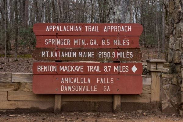
Located within the Chattahoochee National Forest, Springer Mountain is not directly accessible by car. Hikers typically begin their trek after a short approach hike. The most common approach is via the Amicalola Falls State Park, a popular destination in its own right, known for its stunning 729-foot waterfall – the tallest cascading waterfall in the Southeast.
From the park’s visitor center, you can take an 8.8-mile approach trail that connects to the Appalachian Approach Trail, adding an initial, yet beautiful, segment to your overall A.T. journey. This approach trail is well-marked and provides a gradual introduction to the terrain and elevation changes hikers will encounter on the A.T. proper.
Alternatively, for a shorter approach, you can drive to Forest Service Road 42, also known as Nimblewill Gap Road. From here, it’s a much shorter, approximately one-mile hike to Springer Mountain’s summit and the official start of the Appalachian Trail. This option is often favored by those seeking a quicker access point or those who have already experienced Amicalola Falls State Park.
What to Expect at Springer Mountain
Arriving at Springer Mountain, hikers are greeted by a bronze plaque affixed to a rock, officially marking the southern terminus of the Appalachian Trail. This is a momentous spot, filled with anticipation, excitement, and perhaps a touch of nervousness for the adventure ahead.
 The Appalachian trail is usually hikes north from Georgia, starting on Springer Mountain in Georgia. Photo: Getty
Alt text: Hikers begin their Appalachian Trail journey northbound from Springer Mountain in Georgia.
Often, you’ll find other hikers here, starting their own journeys, taking photos, and sharing in the collective energy of embarking on this iconic trail. It’s a place of camaraderie from day one, where future “trail families” often begin to form.
While Springer Mountain itself doesn’t offer expansive panoramic views due to the surrounding forest, it’s the symbolic significance that truly resonates. It’s the point of no return, where the months of planning and preparation turn into action, and the first steps on a 2,000+ mile adventure are taken.
Northbound from Springer: The Traditional Thru-Hike
Starting at Springer Mountain and heading north is the most traditional and popular way to thru-hike the Appalachian Trail. This direction, often referred to as NOBO, allows hikers to gradually acclimatize to the physical demands of the trail as they progress through the seasons.
Beginning in early spring, NOBO hikers experience the blooming wildflowers of the southern states, gradually moving into warmer summer temperatures in the mid-Atlantic region, and finally encountering the crisp autumn air and stunning fall foliage of New England as they approach the northern terminus at Mount Katahdin.
This progression also allows hikers to build “trail legs” and refine their backpacking skills in the relatively gentler terrain of Georgia and North Carolina before tackling the more challenging sections further north. The NOBO direction is also timed to (hopefully) avoid the harsh winter conditions in Maine and allows hikers to reach Katahdin before seasonal closures.
Southbound from Katahdin: The Less Traveled Path
While Springer Mountain marks the southern start, Mount Katahdin in Maine is the northern terminus of the Appalachian Trail. Southbound (SOBO) hikers begin their journey here, heading in the opposite direction towards Georgia.
Starting SOBO presents a different set of challenges. It typically involves beginning in late spring or early summer, tackling the rugged terrain of Maine and New Hampshire first, often considered some of the most demanding sections of the entire trail. SOBO hikers then move southwards, experiencing the seasons in reverse.
While less common, the SOBO route offers a unique perspective and often less crowded trails, particularly in the early stages. It’s generally recommended for experienced backpackers due to the initial difficulty and logistical considerations of starting in Maine.
Flip-Flop Hiking: An Alternative Approach
For those seeking to avoid crowds or desire a different seasonal experience, flip-flop hiking is another option. This involves starting in the middle of the trail, hiking in one direction to an end point, and then “flipping” back to the starting point to hike the remaining section.
A popular flip-flop strategy involves starting at Harpers Ferry, West Virginia, the symbolic midpoint of the A.T., and hiking north to Maine. Then, hikers return to Harpers Ferry to complete the southern section down to Springer Mountain. This can offer milder weather windows and distribute hiker traffic more evenly along the trail.
Planning Your Northbound Hike from Springer Mountain
If you’re planning a traditional northbound thru-hike starting at Springer Mountain, here are a few key considerations:
-
Permits and Registration: While there’s no permit required to hike the Appalachian Trail itself, you may need permits for certain areas along the way, such as the Great Smoky Mountains National Park. Registering your thru-hike with the Appalachian Trail Conservancy (ATC) is highly recommended. This helps the ATC monitor trail usage and provides valuable data for trail management and conservation efforts.
-
Timing: The typical starting window for NOBO hikers is March to April. Starting too early can mean encountering lingering winter conditions in the southern mountains, while starting too late may mean facing excessive heat and arriving in Maine too late in the season.
-
Gear and Preparation: Thoroughly research and test your gear before starting. Ensure you have appropriate clothing for varying weather conditions, reliable navigation tools, and essential backpacking equipment. Physical conditioning is also crucial. Begin training hikes well in advance to prepare your body for the daily demands of long-distance hiking.
-
Early Stages of the Trail: The initial miles from Springer Mountain are moderately challenging, gradually introducing hikers to the ups and downs of the Appalachian terrain. The first major peak, Blood Mountain, comes relatively early, offering a taste of the elevation gains to come.
Why Springer Mountain is the Perfect Starting Point
Springer Mountain is more than just a geographical marker; it’s the emotional and symbolic launchpad for countless Appalachian Trail journeys. Starting here provides a sense of tradition, community, and a tangible beginning to a monumental endeavor.
The approach through Amicalola Falls State Park offers a beautiful and fitting prelude to the wilderness experience ahead. The gradual transition into the trail allows hikers to mentally and physically adjust to the challenges, making Springer Mountain an ideal and iconic place to begin your Appalachian Trail adventure.
 The notable markers of the Appalachian Trail will guide you the entire way up the route. Photo: Getty
Alt text: White blaze trail markers guide hikers along the Appalachian Trail.
Conclusion: Your Journey Begins at Springer Mountain
“Where does the Appalachian Trail start?” The answer, for most, is Springer Mountain, Georgia. This southern terminus is not just a point on a map; it’s the starting gate for an unforgettable journey of self-discovery, physical endurance, and immersion in the beauty of the American wilderness.
Whether you dream of a full thru-hike or a section hike, understanding the significance of Springer Mountain and the northbound starting point is essential for planning your Appalachian Trail experience. As you stand at that bronze plaque, ready to take your first steps north, you’re not just beginning a hike; you’re embarking on a transformative adventure that will stay with you long after you reach your destination, wherever that may be along the legendary Appalachian Trail.