
Just west of Bozeman, Montana, a remarkable event occurs that marks the beginning of America’s longest river. At a place called Three Forks, the Gallatin, Jefferson, and Madison rivers converge, giving birth to the mighty Missouri River. This is the definitive answer to the question, “Where Does The Missouri River Start?” From this point, the Missouri embarks on an epic journey of over 2,300 miles before merging with the Mississippi River in Missouri, near St. Louis. Together, they form the fourth longest river system in the world, flowing southward into the Gulf of Mexico.
The Missouri River holds a profound significance, particularly for the Great Plains, where it has been the “Center of Life” for millennia. This river has acted as a crucial artery for exploration, sustenance, trade, and transportation, impacting millions throughout history. Notably, the Missouri River watershed encompasses about a quarter of all agricultural land in the United States, playing a vital role in providing over a third of the nation’s wheat, flax, barley, and oats. Its historical and future importance to American culture cannot be overstated.
Historically, the Missouri River was famously nicknamed the “Big Muddy,” a testament to the immense quantities of sediment it carried. However, the construction of dams, levees, and channelization projects over time has significantly reduced the sediment load. Today, while still powerful, the river might be better characterized as a gentle giant in many stretches.
It’s primarily in its upper reaches that the Missouri River truly retains its untamed character. Even a leisurely summer float through the Upper Missouri River Breaks National Monument offers a profound sense of wilderness. Here, a 149-mile section, designated as Wild and Scenic, meanders downstream from Fort Benton, Montana, towards the Charlie Russell National Wildlife Refuge. This very area captivated Lewis and Clark for three weeks in 1805, and it now stands as a premier segment of the Lewis & Clark National Historic Trail. Remarkably, modern river travelers can still camp at the same sites used by these legendary explorers.
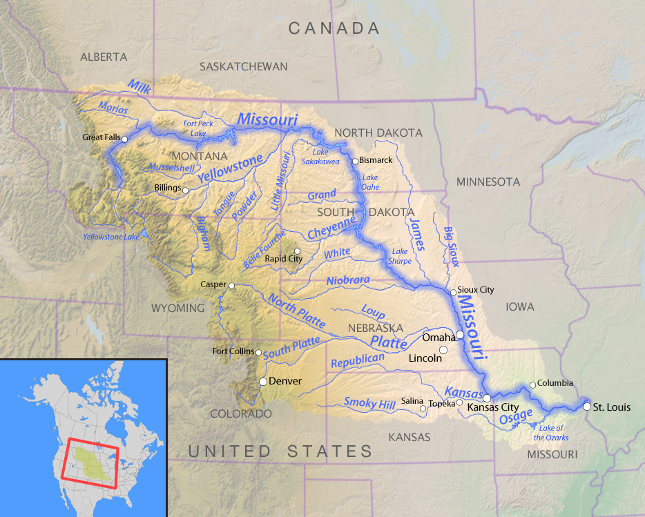
 Map of the Missouri River basin highlighting its source and tributaries in North America
Fascinating Facts About the Missouri River Source and Beyond
The Missouri River’s history is rich with captivating details:
- Lewis and Clark’s Expedition: In 1805, Lewis and Clark faced the Missouri’s strong spring current as they journeyed upstream, navigating the very waters originating from Three Forks.
- European Discovery: French explorers Louis Jolliet and Jacques Marquette were the first Europeans to officially document their discovery of the Missouri River in May 1673, opening it up to wider awareness.
- Fur Trade Era: During the peak of the fur trade, steamboats could travel all the way to Fort Benton, MT. This made Fort Benton a significant trade hub and one of the largest settlements between Minneapolis and Seattle during its prosperous period.
- Black Eagle Dam Incident: In a dramatic event in 1908, part of the Black Eagle Dam in Great Falls was intentionally dynamited to protect nearby factories from flooding when the upstream Hauser Dam failed, causing widespread catastrophic flooding.
- Pallid Sturgeon Stronghold: The upper Missouri River system is a crucial habitat for the endangered pallid sturgeon. These ancient fish can weigh around 85 pounds, live for up to a century, and their lineage dates back an astounding 70 million years.
States Traversed by the Missouri River
The Missouri River’s extensive journey flows through a total of seven states:
Montana, North Dakota, South Dakota, Nebraska, Iowa, Kansas, and Missouri.
Anglers in the Missouri River basin may encounter unique native fish species, including the prehistoric-looking paddlefish and the endangered pallid sturgeon. The entire basin is home to approximately 150 species of fish, along with 300 bird species and diverse mammals like elk, whitetail deer, and mule deer, contributing to a substantial seasonal hunting economy. Even occasional grizzly bears have been spotted near Fort Benton, highlighting the area’s wild nature. Several threatened and endangered species are finding refuge along the Missouri, but restoring wildlife populations to their former levels requires ongoing efforts in flow management, habitat protection, and adaptive river system management.
A History Shaped by Floods
Major floods have always been an inherent part of life along the Missouri River, teaching valuable lessons about river management over time. For over 75 years, the U.S. Congress has tasked the U.S. Army Corps of Engineers with managing flood control, navigation, and irrigation on the Missouri. This has been done through impoundment, channelization, and dredging. Ironically, the resulting system of large reservoirs in the upper river and the deepened, narrowed channel in the lower river has, in some ways, exacerbated flood damage, posing risks to communities, wildlife, recreation, and the overall health of the river.
Towards a Sustainable Future for the Missouri River
Moving forward, sound scientific practices and public engagement are essential for achieving smarter river management. This approach aims to protect both communities and the environment. A fundamental step is recognizing that traditional methods like levees, dredging, and impoundments can actually worsen flooding in the long run.
A more effective alternative involves reconnecting the naturally wide, shallow river with its floodplain wherever feasible. This includes strategically removing levees, adjusting dam release schedules to mimic natural river flows, and revitalizing riparian cottonwood forests. These forests are crucial for absorbing water and providing rich wildlife habitat within the Great Plains. This adaptive strategy is not only more cost-effective to maintain but also yields multiple benefits – supporting fish and wildlife populations and boosting the recreation economy, creating a triple win for all stakeholders.