Hurricane Beryl is currently charting a course across the Caribbean Sea, prompting concerns and preparations across multiple regions. After reaching Category 5 status and impacting Grenada, this powerful storm has slightly weakened but remains a dangerous Category 4 hurricane. The key question on everyone’s mind is: Where Is Beryl Headed next, and what impact will it have? This article breaks down the current path, forecasts, and potential impacts of Hurricane Beryl.
Beryl’s Current Status and Location
As of the latest reports, Hurricane Beryl is located south of the Dominican Republic and is moving west-northwest at a speed of 22 mph. While it has decreased slightly from its peak Category 5 intensity, Beryl still packs maximum sustained winds of 150 mph, firmly placing it as a major Category 4 hurricane. Weather experts predict that Beryl is likely to remain a major hurricane through at least Wednesday as it continues its westward trajectory across the Caribbean.
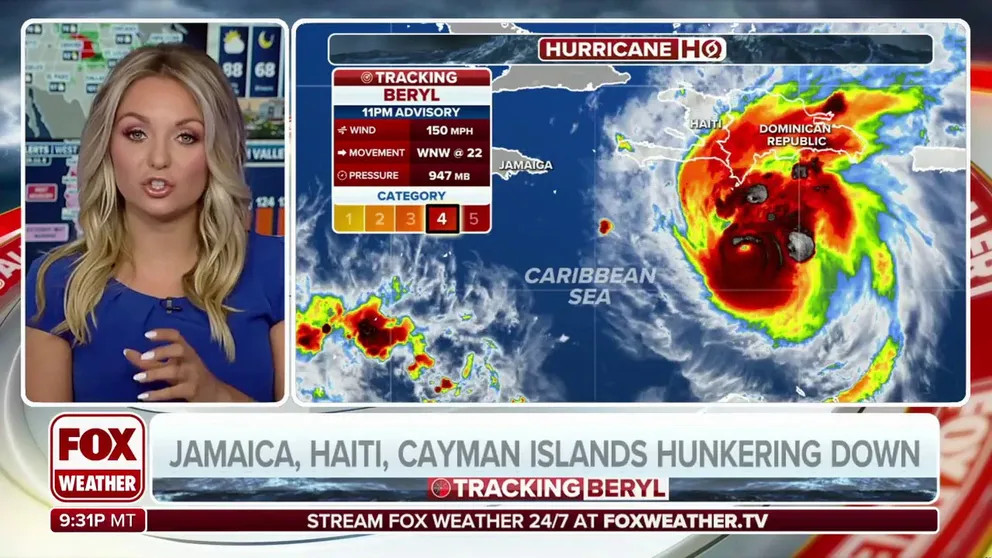 Animated weather radar showing Hurricane Beryl approaching Jamaica in the Caribbean Sea.
Projected Path and Potential Landfalls
The National Hurricane Center (NHC) indicates that Hurricane Beryl’s path is directed towards the west-northwest. This projected trajectory raises concerns for several landmasses in the Caribbean and beyond. Current forecasts suggest that Beryl will pass near Jamaica and potentially maintain hurricane strength as it approaches the Yucatan Peninsula in Mexico.
Due to the increasing threat, the government of Mexico has issued a Hurricane Watch for the eastern coast of the Yucatán Peninsula. Belize has also issued a Tropical Storm Watch for a significant portion of its coastline. These alerts highlight the growing concern as Beryl advances.
Furthermore, a Hurricane Warning is now in effect for Jamaica and the Cayman Islands, signaling imminent hurricane conditions. A Hurricane Watch has been issued for parts of the southern coast of Haiti, and a Tropical Storm Warning is in place for the southern coast of Haiti and parts of the southern coast of the Dominican Republic. These warnings and watches underscore the widespread risk across the Caribbean.
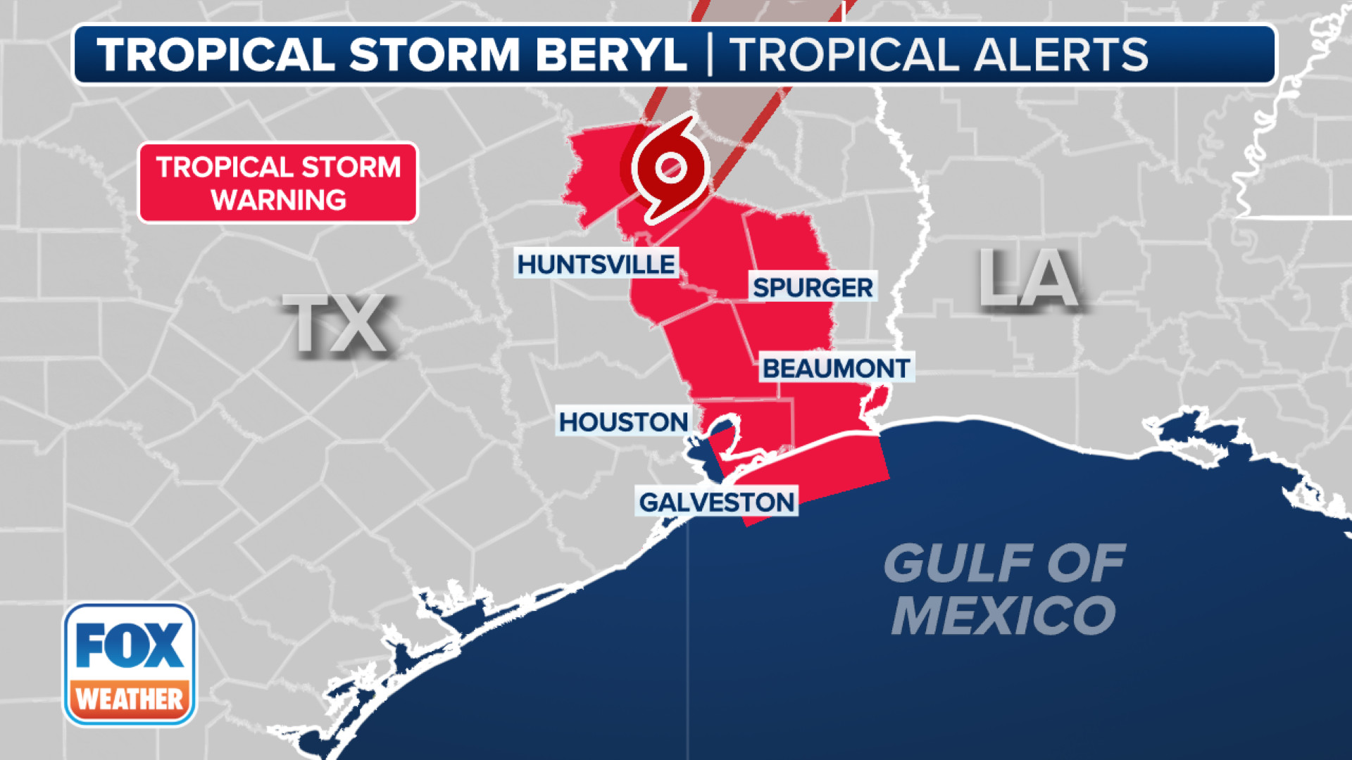 Map of the Caribbean showing Hurricane Warnings and Watches issued by the National Hurricane Center for Hurricane Beryl.
Uncertainty as Beryl Approaches Yucatan and Gulf of Mexico
Looking further ahead, the forecast becomes more uncertain as Beryl approaches the Yucatan Peninsula, potentially late Thursday or Friday. Experts suggest that Beryl may weaken by this time due to atmospheric conditions and possible interaction with the mountainous terrain of Jamaica. However, the unusually warm waters of the Caribbean Sea present a factor that could lead to rapid regeneration of the storm’s intensity.
This dynamic creates significant uncertainty regarding Beryl’s strength as it nears the Yucatan Peninsula. The storm’s potential path beyond the Yucatan is also being closely monitored. Forecast models indicate that Beryl could emerge into the Bay of Campeche and possibly move into the western Gulf of Mexico.
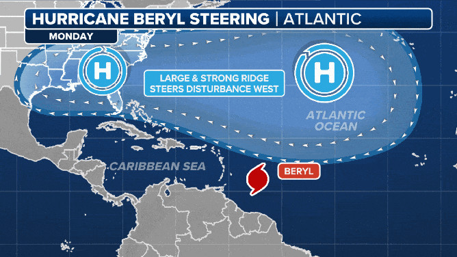 Animated graphic showing Hurricane Beryl's steering currents in the Caribbean Sea and Gulf of Mexico.
Potential Impact on the US Gulf Coast and Texas
While current models suggest a higher probability of impact on Mexico, the southern coast of Texas is not entirely out of the forecast cone. The interplay between an upper-level dip in the jet stream and a weakening high-pressure ridge over the southern Plains could create a path of least resistance for Beryl towards the US Gulf Coast.
Areas in South Texas, including Brownsville, are advised to closely monitor the storm’s progression. The forecast beyond Thursday and Friday remains unclear, and the precise track Beryl takes after crossing the Yucatan Peninsula will be crucial in determining the potential impact on the US. Weather experts emphasize that a clearer picture will likely emerge by Thursday or Friday.
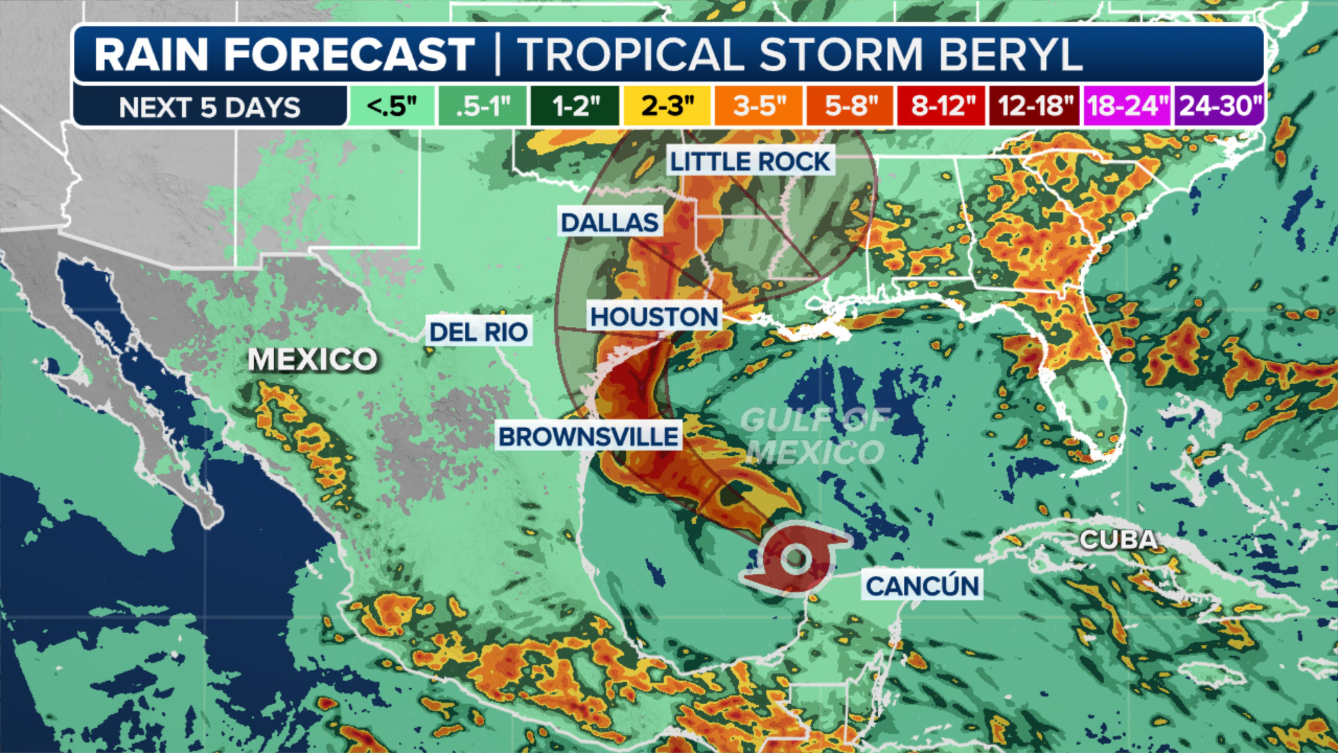 Projected rainfall amounts across the Caribbean and Central America due to Hurricane Beryl.
Staying Informed
Hurricane Beryl is a dynamic and powerful storm, and its future path and intensity carry considerable uncertainty. Residents in the Caribbean, Mexico, and the US Gulf Coast, particularly Texas, are urged to stay informed and monitor updates from the National Hurricane Center and local weather authorities. Preparedness is key as Beryl continues its journey across the Atlantic basin.