Colombia, a country celebrated for its rich culture, vibrant cities, and, most importantly, its breathtaking landscapes, is situated in South America. But Where Is Colombia Country exactly? Nestled in the northwestern corner of the continent, Colombia boasts a unique geographical position, bordered by the Caribbean Sea to the north and the Pacific Ocean to the west. This strategic location makes it the only South American country with coastlines on both the Caribbean Sea and the Pacific Ocean.
 Physical features of Colombia
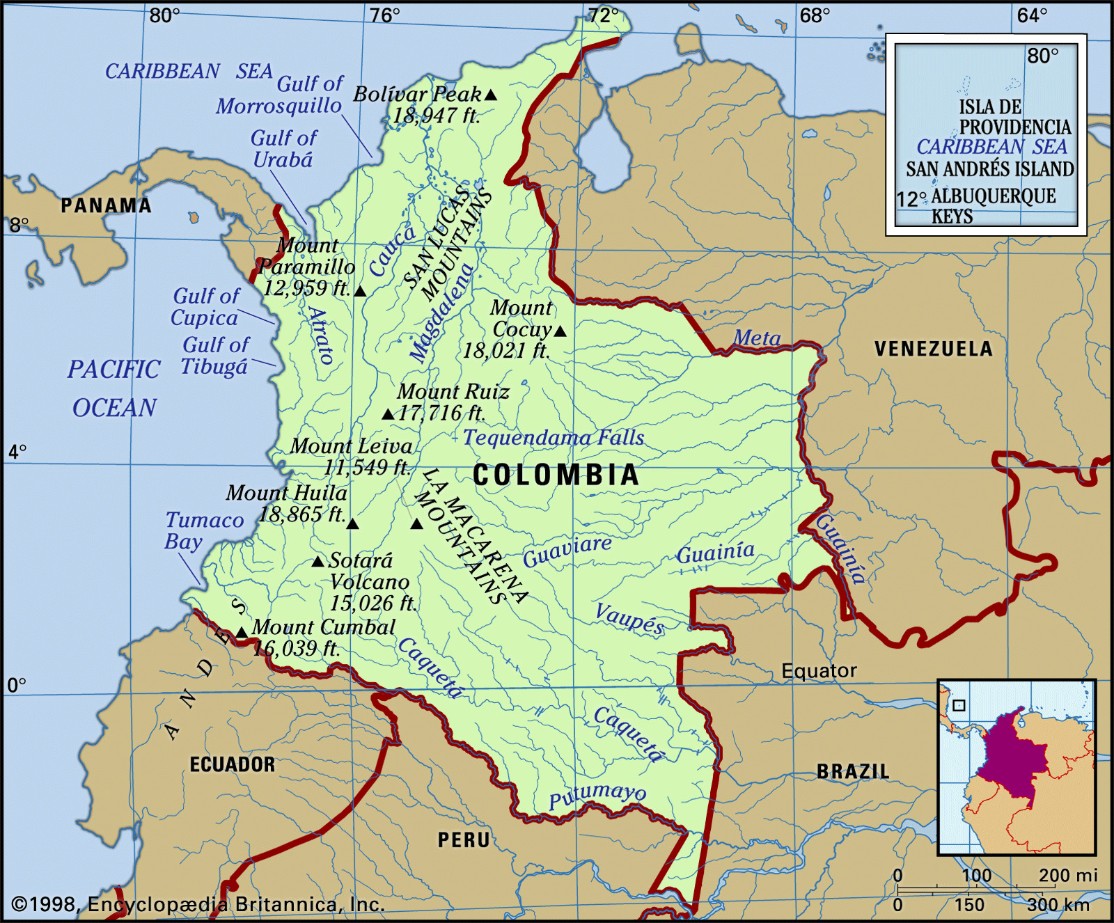
A detailed map showcasing the diverse physical features of Colombia, highlighting its Andean mountains, river systems, and coastal plains.
Colombia’s neighbors include Panama to the northwest, Venezuela and Brazil to the east, and Ecuador and Peru to the south. This places Colombia firmly within the tropics, a factor that significantly contributes to its extraordinary biodiversity and varied climates. From towering Andean peaks to lush Amazonian rainforests and sun-kissed Caribbean beaches, Colombia’s geographical diversity is truly remarkable.
The Majestic Andes Mountains in Colombia
The Andes Mountains, one of the world’s longest and highest mountain ranges, are a defining feature of Colombia’s geography. Entering Colombia from Ecuador, the Andes split into three distinct parallel ranges: the Cordillera Occidental (Western Range), the Cordillera Central (Central Range), and the Cordillera Oriental (Eastern Range). These ranges run roughly north to northeast, shaping the western part of the country and influencing climate, population distribution, and land use.
The valleys of the Magdalena and Cauca rivers act as natural separators between these ranges, creating fertile lowlands that have historically served as vital transportation routes and agricultural centers. Volcanic activity has played a significant role in shaping the Cordillera Central, contributing fertile volcanic ash to the soil and creating stunning volcanic peaks, some of which remain active today.
The Cordillera Occidental is the lowest and least populated of the three ranges, forming a barrier between the Cauca Valley and the Pacific coast. In contrast, the Cordillera Central is the highest, featuring numerous volcanoes and high plateaus crucial for Colombia’s renowned coffee production. The Cordillera Oriental, the broadest range, extends towards Venezuela and is characterized by high plateaus like the Sabana de Bogotá, where Colombia’s capital city is located.
Key Rivers and Valleys: The Magdalena and Cauca
The Magdalena and Cauca rivers are the two principal rivers of Colombia, flowing between the Andean ranges and playing a crucial role in the country’s geography and history. The Magdalena River, Colombia’s longest river, runs between the Cordillera Central and Cordillera Oriental, serving as a major transportation artery and a source of life for the surrounding regions. The Cauca River flows between the Cordillera Occidental and Cordillera Central, its valley known for its fertile lands and agricultural productivity.
A scenic view of the Cauca River flowing through the Andes Mountains in Colombia, showcasing the rugged terrain and vital waterways.
These river valleys have been historically significant for agriculture and settlement, providing fertile land and access to water. The Cauca Valley, in particular, is known for its agricultural richness, a result of volcanic activity and river sedimentation over millennia.
Beyond the Andes: Coastal Lowlands and Eastern Plains
While the Andes dominate western Colombia, the country also encompasses extensive lowlands along both its Caribbean and Pacific coasts, and vast eastern plains stretching towards the Orinoco and Amazon basins. The Caribbean coastal lowlands, also known as the Atlantic lowlands, extend inland from the Caribbean Sea, featuring savannas, hills, and seasonally flooded areas. The Pacific coastal lowland is narrower and characterized by high rainfall and dense rainforests.
East of the Andes lies the Llanos Orientales, or Eastern Plains, a vast savanna region that extends to the Orinoco River. Further south, the Amazonian rainforest, known as the selva, covers a significant portion of southeastern Colombia, contributing to the country’s incredible biodiversity and playing a vital role in global ecosystems.
The Unique Santa Marta Mountains
Separated from the Andes, the Santa Marta Mountains are an isolated mountain range rising dramatically from the Caribbean coast. This massif is home to Colombia’s highest peaks, Cristóbal Colón and Simón Bolívar, reaching snow-capped summits despite their proximity to the equator. The Santa Marta Mountains represent a unique geographical feature, showcasing diverse ecosystems ranging from coastal dry forests to high-altitude glaciers.
Conclusion: Colombia’s Geographic Tapestry
In conclusion, where is Colombia country? Colombia is geographically positioned in northwestern South America, a location that gifts it with an astounding variety of landscapes. From the towering Andes Mountains that bisect the western regions to the expansive Caribbean and Pacific coastlines, and the Amazonian rainforest merging into eastern plains, Colombia’s geography is exceptionally diverse. This remarkable physical variety underpins its ecological richness and cultural diversity, making Colombia a truly unique and captivating nation in South America.