
Greenland, a land of immense ice sheets and dramatic fjords, often sparks curiosity about its precise location on the globe. To answer the fundamental question, Where Is Greenland Located?, it lies in the North Atlantic Ocean, geographically positioned in North America, northeast of Canada and separated from Iceland by the Denmark Strait. While physically part of North America, Greenland is politically linked to Europe as an autonomous constituent country within the Kingdom of Denmark. This unique positioning makes Greenland a fascinating subject in terms of both geography and geopolitics.
Delving into Greenland’s Geographic Coordinates and Regional Context
To pinpoint Greenland’s location more precisely, we can look at its geographic coordinates. Greenland stretches from approximately 59° to 83° North latitude and 11° to 73° West longitude. A significant portion, about two-thirds of the island, lies within the Arctic Circle, extending far north towards the North Pole. Its northernmost point is closer to the North Pole than any other landmass except for some islands in Canada.
To its west, Greenland is bordered by Canada, with Ellesmere Island being the closest landmass, separated by a mere 16 miles (26 kilometers). Across the Denmark Strait to the east lies Iceland, approximately 200 miles (320 kilometers) away. While geographically closer to North America, its political ties to Denmark place it within a European context. This location at the juncture of the Arctic, North Atlantic, and near both North America and Europe, gives Greenland a unique strategic and environmental significance.
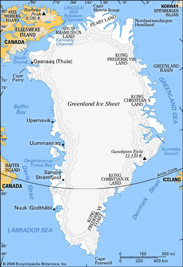 Map of Greenland highlighting the major geographic regions and the locations of human settlement, illustrating Greenland's location within the North Atlantic and proximity to Canada and Iceland
Greenland’s Position as Part of the North American Landmass
Geologically, Greenland is considered part of the North American continent. It is structurally an extension of the Canadian Shield, a vast area of Precambrian rock forming the core of the continent. A submarine ridge, not very deep, physically connects Greenland to North America. This geological connection reinforces its geographical placement within the North American region, despite its political affiliations.
The narrow channel separating Greenland from Ellesmere Island further emphasizes its proximity to the North American mainland. This strait, though navigable, highlights the close geographical relationship between Greenland and the Canadian Arctic Archipelago. Understanding this geological and continental context is crucial to grasping Greenland’s true location.
Coastal Geography and Immense Size
Greenland is renowned for its extensive and deeply indented coastline, stretching an astonishing 24,430 miles (39,330 kilometers) – comparable to the Earth’s circumference at the Equator. This intricate coastline is carved by numerous fjords, long, narrow inlets created by glacial activity, particularly prominent on both the east and west coasts. These fjords contribute to the dramatic and often desolate beauty of Greenland’s landscape.
In terms of size, Greenland is the world’s largest island, significantly larger than many countries. To put it in perspective, it is more than three times the size of the US state of Texas. It extends approximately 1,660 miles (2,670 kilometers) from north to south and reaches a maximum width of over 650 miles (1,050 kilometers) from east to west. This immense size, coupled with its northerly location, contributes to its unique climate and environment.
The Dominant Ice Sheet and Habitable Locations
A defining feature of Greenland’s geography is its massive ice sheet, second in size only to Antarctica’s. This ice sheet blankets over four-fifths of Greenland’s land area, significantly shaping where life can thrive. Human settlements are largely confined to the coastal areas, the ice-free fringes of the island.
The immense ice sheet, with an average thickness of 5,000 feet (1,500 meters) and reaching up to 10,000 feet (3,000 meters) at its thickest, dictates the habitable zones of Greenland. The sheer scale of the ice and its glaciers, like the Jakobshavn Glacier, which is among the fastest in the world, underscores the powerful influence of ice on Greenland’s geography and where life, both human and animal, can exist.
Arctic Climate: A Consequence of Location
Greenland’s Arctic climate is a direct consequence of its northerly location. While the Gulf Stream has a slight moderating influence on the southwestern coast, the majority of Greenland experiences harsh Arctic conditions. Rapid weather changes are common, and temperatures are generally cold throughout the year.
Winter temperatures can plummet to -30°F (-34°C) in the north, while even summer temperatures in the south average only in the mid-40s°F (around 7°C). The island experiences midnight sun during summer months, and precipitation varies significantly from south to north, with some northern areas classified as Arctic deserts due to minimal rainfall. This challenging climate, dictated by its location, shapes the environment and limits vegetation and human activity across Greenland.
Conclusion: Greenland’s Unique Geographical Identity
In conclusion, Greenland is located in the North Atlantic Ocean, firmly positioned within North America geographically, yet maintaining political links to Europe through Denmark. Its location largely within the Arctic Circle, its proximity to Canada and Iceland, its immense size and extensive coastline, and its dominant ice sheet all contribute to its unique geographical identity. Understanding where Greenland is located is fundamental to appreciating its environment, climate, and its place in the world.