As Hurricane Milton intensified its approach towards Florida’s Gulf Coast on Wednesday afternoon, residents braced for impact as tropical storm-force winds began sweeping across the state. With officials emphasizing the dwindling time for safe evacuations, the looming threat of a major hurricane became starkly real for those in its path.
Hurricane Milton has exhibited fluctuating intensity as it churns closer to Florida, briefly escalating to a Category 3 hurricane on Wednesday afternoon. Millions of Floridians have been placed under evacuation orders, and critical infrastructure like bridges began to close down as the storm is anticipated to unleash significant storm surges, destructive winds, and torrential rainfall across the region.
The Tampa Bay area, a densely populated region home to over 3.3 million people, finds itself directly in Milton’s crosshairs. Remarkably, this area has managed to avoid a direct hit from a major hurricane for over a century. However, Milton’s arrival threatens to break this long-standing streak, particularly as communities are still reeling from the impact of Hurricane Helene just two weeks prior. Helene, though not a direct hit to Tampa Bay, still caused significant issues in the region.
Forecasters at the National Hurricane Center have issued stern warnings, emphasizing that Hurricane Milton, which has expanded in size, is “expected to remain an extremely dangerous major hurricane” as it approaches and makes landfall on Florida’s coastline. The crucial question on everyone’s mind is: where exactly will this powerful storm make landfall?
Milton is projected to make landfall along Florida’s Gulf Coast late Wednesday. Governor Ron DeSantis, in a Wednesday briefing, stated, “We are bracing and prepared to receive a major hit,” underscoring the seriousness of the situation and the state’s readiness to respond.
As of Wednesday afternoon, the eye of the storm was situated approximately 100 miles (155 kilometers) southwest of Tampa, packing sustained winds of a formidable 125 mph (205 kph). The forecast indicates that Milton is expected to maintain hurricane strength as it traverses central Florida on Thursday, continuing its trajectory towards the Atlantic Ocean.
President Joe Biden, demonstrating the national significance of the impending storm, postponed an overseas trip to remain at the White House to personally monitor Hurricane Milton’s progress. His warning that Milton “could be one of the worst storms in 100 years to hit Florida” highlights the potential for catastrophic impact and the urgency of preparedness efforts.

Alt text: Hurricane Milton approaching Florida coast as seen from space, illustrating the storm’s vast size and potential impact.
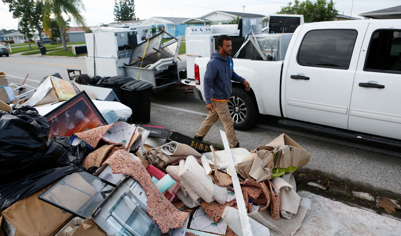
The Gulf Coast of Florida is particularly susceptible to the devastating effects of storm surge. Even Hurricane Helene, which made landfall approximately 150 miles (240 kilometers) north of Tampa in the Florida Panhandle, caused drowning fatalities in the Tampa area due to storm surges that reached 5 to 8 feet (1.5 to 2.5 meters) above normal tide levels.
With Hurricane Milton, forecasters are predicting a potentially catastrophic storm surge of 10 to 15 feet (3 to 4.5 meters) in Tampa Bay. This alarming prediction represents the highest storm surge ever forecasted for this location, prompting mandatory evacuation orders for communities throughout the coastal regions.
Hillsborough County, which encompasses Tampa, mandated evacuations for areas adjacent to the bay and all mobile and manufactured homes by Tuesday night. Tampa Mayor Jane Castor delivered increasingly dire warnings to residents contemplating riding out the storm, emphasizing the life-threatening risk posed by such a significant storm surge. She chillingly stated, “So if you’re in it, basically that’s the coffin that you’re in,” highlighting the extreme danger of being caught in the predicted surge.
Hurricane Milton is expected to track across central Florida, unleashing up to 18 inches (46 centimeters) of rainfall as it progresses towards the Atlantic Ocean, according to the National Hurricane Center’s projections. This combination of storm surge, high winds, and torrential rain presents a multifaceted threat to communities in its path.
Alt text: Aerial view of coastal Florida community showing vulnerability to hurricane storm surge and flooding, emphasizing potential for widespread damage.
While Florida braces for the brunt of Hurricane Milton, it’s worth noting the storm’s earlier impact on Mexico. As Milton traversed the Yucatan Peninsula, authorities in the Mexican state of Yucatan reported relatively minor storm damage. Yucatan Governor Joaquín Díaz indicated that power lines, light poles, and trees were downed near the coast, and some small thatched-roof structures were destroyed. Encouragingly, no deaths or injuries were reported in Mexico as a result of Milton’s passage.
For individuals with travel plans to Florida, significant disruptions are underway. Tampa International Airport suspended flight operations on Tuesday morning and clarified via social media platform X that the airport is not designated as a shelter for people or vehicles. Similarly, St. Pete-Clearwater International Airport, located within a mandatory evacuation zone, also ceased operations after its final flight on Tuesday.
Orlando’s extensive tourism industry, situated approximately 84 miles (135 kilometers) inland from Tampa, began to shut down on Tuesday. Orlando International Airport, a major national and state transportation hub, announced it would halt operations on Wednesday morning. Furthermore, major theme parks including Walt Disney World, Universal Orlando, and SeaWorld initiated closures, with Universal Orlando and SeaWorld extending their closures through Thursday, and Disney anticipated to follow suit. These closures highlight the widespread impact of the storm, extending beyond the immediate coastal landfall area.
Scientists are characterizing this hurricane season as unusually erratic. Forecasters had anticipated an active Atlantic hurricane season, and their predictions were seemingly validated when Beryl became the earliest storm on record to reach Category 5 status. However, a period of unusual quiet followed from August 20th to September 23rd, traditionally the peak of hurricane season, as noted by Colorado State University hurricane researcher Phil Klotzbach.
This quiet period was abruptly broken by a surge of hurricane activity. Between September 26th and October 6th, an unprecedented five hurricanes formed, more than double the previous record of two for that timeframe. Furthermore, an unprecedented three hurricanes were simultaneously active in October on Sunday and Monday. Hurricane Milton itself exemplified this rapid intensification, escalating from a tropical storm with 40 mph winds to a Category 5 hurricane in a mere 46.5 hours. This unusual pattern of rapid intensification and clustered hurricane formation has led scientists to label this hurricane season as exceptionally “weird.”
The increasing frequency and intensity of these storms prompt questions about weather control, but scientists emphasize that hurricanes are far too powerful to manipulate. Instead, the focus is shifting towards understanding and mitigating the impacts of climate change, which is believed to be providing more energy and fuel for storms like Helene and Milton, exacerbating their intensity and destructive potential.
Hurricanes originate from tropical waves interacting with warm ocean waters. These systems can also be fueled by thunderstorms. The weather system progresses westward as warm, moist air rises, creating a low-pressure area underneath. As air rises and cools, it condenses to form clouds and thunderstorms, the building blocks of a hurricane.
A hurricane is defined by maximum sustained winds of 74 mph (120 kph) or higher. Tropical cyclones with sustained winds between 39 and 73 mph (63 kph to 120 kph) are classified as tropical storms, while those with winds below 39 mph are termed tropical depressions. The Atlantic hurricane season officially spans from June 1st to November 30th each year.
The Saffir-Simpson Hurricane Wind Scale categorizes hurricanes from Category 1 to Category 5, based on wind speeds and potential damage. Category 1 hurricanes, with winds from 74 to 95 mph, can cause significant damage even to well-constructed homes. Hurricanes of Category 3 or higher are classified as major hurricanes, with Category 3 storms starting at 111 mph (180 kph).
A Category 5 hurricane represents the most catastrophic level of storm. These storms can obliterate homes, cause widespread power outages, and isolate entire communities due to downed trees and utility infrastructure. They inflict critical damage to essential infrastructure such as roads, bridges, and dams, rendering large areas uninhabitable for extended periods.
Storm surge refers to the abnormal rise of seawater level caused by a storm, exceeding normal tide levels. It’s crucial to differentiate storm surge from wave height; storm surge is the overall elevated water level, upon which waves are superimposed. A significant storm surge, especially when coinciding with high tide and amplified by wave action, can have devastating consequences, capable of leveling buildings, collapsing bridges, and inundating vast areas.
The extent of destruction from a hurricane is determined by its intensity and the specific location of landfall. Even relatively weaker hurricanes can cause substantial damage and fatalities if they strike vulnerable areas or critical infrastructure. Mid-strength hurricanes, like Hurricane Jeanne in Florida in 2004, have demonstrated the capacity to inflict devastating damage to homes, infrastructure, and power grids, with casualties often resulting from flooding, accidents, and storm-related disruptions.
The deadliest hurricane in U.S. history was the 1900 Galveston hurricane in Texas, claiming at least 8,000 lives and causing immense property damage. More recent examples of extraordinarily deadly hurricanes include Hurricane Maria in 2017, responsible for over 3,000 deaths, and Hurricane Katrina in 2005, which caused over 1,300 fatalities. These historical events underscore the immense destructive potential of hurricanes and the importance of preparedness and timely response.
As Hurricane Milton makes its expected landfall on Florida’s Gulf Coast, likely in the Tampa Bay area, residents and authorities remain on high alert. The combination of a major hurricane, a significant storm surge, and heavy rainfall poses a severe threat. The coming hours will be critical in assessing the full impact of this powerful storm.