The Gulf of Mexico has been churning with disturbed weather, and it has now officially formed into Tropical Storm Milton. This storm is anticipated to strengthen as it moves across the very warm Gulf waters, and current predictions suggest it will make landfall somewhere along Florida’s West Coast around midweek. There’s a potential for Milton to intensify into a major hurricane before reaching the coast.
The current forecast track cone centers near Tampa, Florida, but it’s important to note that the cone is quite broad. This width signifies considerable uncertainty regarding Milton’s precise path. Residents along the entire West Coast of Florida should be vigilant. This region is still recovering from storm surges caused by Hurricane Helene in late September, which reached record heights and caused significant damage. Early projections for storm surge from Tropical Storm Milton are even more concerning, prompting emergency management teams to prepare for extensive evacuations from low-lying areas vulnerable to inundation. In addition to storm surge, the region can expect strong winds, heavy rainfall, and the possibility of tornadoes. It’s also possible that the East Coast of Florida could experience some storm surge as Milton crosses the peninsula and moves into the Atlantic, altering local wind patterns.
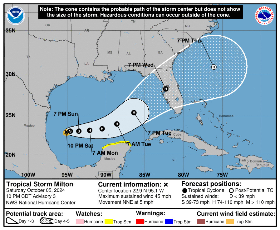
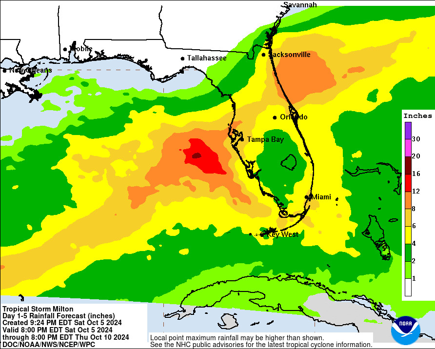
If you live anywhere on the Florida peninsula, along the Florida Panhandle coast, or in coastal southeast Georgia, it is crucial to monitor Tropical Storm Milton closely and stay updated on its predicted path. While the rainfall patterns are based on the current forecast cone, it’s wiser to prepare for a worst-case scenario rather than focusing solely on the cone’s center line, as storm tracks can shift, as seen with Hurricane Helene. Weather forecasts are updated every three hours with new data incorporated into models. Therefore, always use the most current forecast information for planning and be prepared for ongoing changes in the predictions. Historically, the impacts from storms are often more severe on the right side of the storm’s track. The specific effects you experience will depend on the ultimate path Milton takes. Furthermore, be aware that rain may begin early this week as a precursor rain event, similar to what occurred with Hurricane Helene. This pre-storm rainfall could be more pronounced on the northern side of the current forecast cone due to interaction with a weather front. This early rain will saturate the ground, increasing the risk of flooding once Tropical Storm Milton makes landfall.
The agricultural sector in Florida could face substantial economic losses as Tropical Storm Milton threatens to impact major citrus and vegetable production areas. Preparations in these regions should be completed by Tuesday evening, and even earlier if you anticipate being affected by the precursor rainfall. It’s important to note that supplies like generators and gas cans may be limited due to high demand following the recent impacts of Hurricane Helene. Consider having cash on hand, as power outages can disrupt credit card processing. Hand sanitizer can also be a valuable asset if access to clean water is compromised due to power outages affecting water pumps or flooding impacting water treatment facilities.