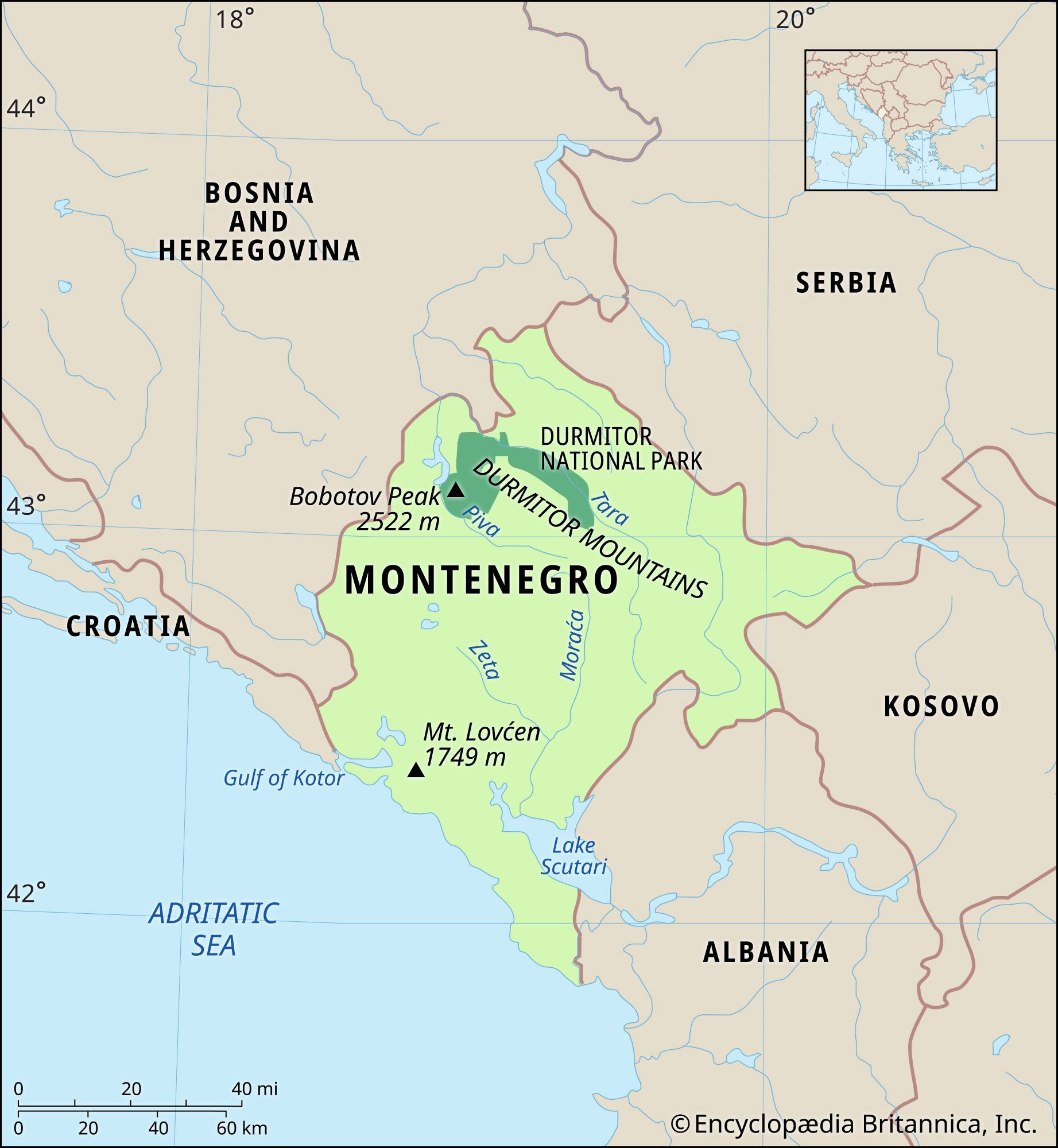
Montenegro, often hailed as a hidden gem in Europe, is a country brimming with dramatic mountains, medieval villages, and a stunning coastline. But Where Is Montenegro exactly? Nestled in the west-central Balkans, at the southern tip of the Dinaric Alps, Montenegro boasts a strategic and picturesque location. It opens to the Adriatic Sea to the southwest, sharing borders with Croatia and to the northwest with Bosnia and Herzegovina. To its northeast lies Serbia, with Kosovo to the east, and Albania marking its southeastern boundary.
The administrative heart of Montenegro is Podgorica, while Cetinje, steeped in history, serves as the nation’s cultural soul and former royal capital. Throughout much of the 20th century, Montenegro was part of Yugoslavia, later becoming a constituent republic within the federation of Serbia and Montenegro from 2003 to 2006. Today, it stands proudly as an independent nation, attracting visitors with its compelling blend of natural beauty and historical significance.
Discovering Montenegro’s Land and Topography
The very name “Montenegro,” derived from Venetian Italian and mirroring the Slavic “Crna Gora,” translates to “Black Mountain.” This evocative name is a direct nod to Mount Lovćen, a historically significant peak near the Adriatic coast. Mount Lovćen served as a stronghold for Montenegrins during centuries of resistance against Ottoman rule. Remarkably, Montenegro holds the distinction of being the only Balkan state never fully subjugated.
The southwestern part of Montenegro, the historical heartland, is characterized by a karst landscape. This terrain is predominantly arid and hilly, yet it harbors pockets of cultivable land, notably around Cetinje and within the Zeta valley. Venturing eastward, the landscape transforms as it embraces sections of the Dinaric Alps, including the majestic Durmitor massif. This region is notably more fertile, adorned with expansive forests and verdant upland pastures. Montenegro’s rivers exhibit a dual drainage pattern. The Piva, Tara, and Lim rivers carve northerly paths, while the Morača and Zeta rivers flow southward, showcasing the country’s diverse hydrological features.
 Montenegro physical map highlighting mountainous terrain and river systems
Montenegro’s Diverse Relief: From Mountains to Coast
Montenegro’s terrain is remarkably diverse, ranging from towering mountains along its eastern borders with Kosovo and Albania to a segment of the Karst region of the western Balkan Peninsula. This gives way to a narrow coastal plain, varying between just 1 to 4 miles (2 to 6 km) in width along the Adriatic. Intriguingly, this coastal plain disappears entirely in the north, where Mount Lovćen and other peaks ascend dramatically from the Gulf of Kotor’s inlet, creating a breathtakingly rugged coastline. The coastal area is also known for its seismic activity, a testament to the dynamic geological forces at play.
Montenegro’s Karst region generally sits at an elevation of 3,000 feet (900 meters) above sea level, with peaks reaching as high as 6,000 feet (1,800 meters). The lowest point within this Karst expanse is the Zeta River valley, lying at approximately 1,500 feet (450 meters). The Zeta River flows through Nikšić Polje, a characteristic flat-floored, elongated depression typical of karst regions. The underlying limestone bedrock is highly soluble, contributing to the formation of sinkholes and extensive underground cave systems that are hallmarks of karst topography.
The high mountain ranges of Montenegro are among the most rugged in Europe, with average elevations exceeding 7,000 feet (2,000 meters). Bobotov Peak, situated in the Durmitor Mountains, stands as Montenegro’s highest point at 8,274 feet (2,522 meters). These Montenegrin mountains experienced significant ice erosion during the last glacial period, further sculpting their dramatic forms.
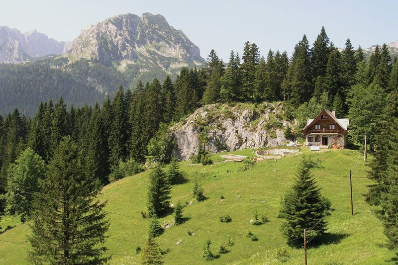 Durmitor National Park showcasing rugged mountain peaks
Waterways and Lakes of Montenegro
Montenegro’s northern regions are drained by the Lim and Tara river systems. These rivers contribute to the Danube basin via the Drina River, which also marks the border between Bosnia and Herzegovina and Serbia. In southern Montenegro, rivers flow directly towards the Adriatic Sea. A significant portion of the karst region’s drainage occurs underground through intricate networks of subterranean channels.
Lake Scutari, known locally as Skadarsko Jezero, is Montenegro’s largest lake. Situated near the coast and extending into northern Albania, it is a substantial body of water, measuring 25 miles (40 km) in length and 10 miles (16 km) in width, with a total surface area of 140 square miles (360 square km). Approximately three-fifths of the lake lies within Montenegrin territory. Lake Scutari occupies a karst polje depression, with its floor dipping below sea level. Montenegro’s mountainous areas are also dotted with numerous smaller, picturesque lakes, enhancing the country’s natural appeal.
Soils and Climate: Defining Montenegro’s Environment
A distinctive soil type in Montenegro’s coastal area is terra rossa. This red soil, resulting from the weathering of dolomite and limestone, is also prevalent in depressions within the Karst region. Higher up in the mountainous areas, above the plateaus, typical gray-brown forest soils and podzols are found, reflecting the altitudinal variation in soil types.
Montenegro’s lower regions benefit from a Mediterranean climate, characterized by dry summers and mild, wet winters. Temperature varies considerably with altitude. Podgorica, near sea level, experiences the warmest July temperatures in the country, averaging 81 °F (27 °C). In contrast, Cetinje, located in the Karst region at an elevation of 2,200 feet (670 meters), has an average temperature that is 10 °F (5 °C) cooler. Average January temperatures range from a mild 46 °F (8 °C) at Bar on the southern coast to a chilly 27 °F (−3 °C) in the northern mountains.
Montenegro’s mountains are among the wettest areas in Europe. Crkvice, in the Karst above the Gulf of Kotor, receives nearly 200 inches (5,100 mm) of precipitation annually. Like much of the Mediterranean region, precipitation is concentrated during the colder months, but the higher mountains also experience a secondary rainfall maximum in the summer. Snow is infrequent along the Montenegrin coast, averaging only 10 days in karst polje depressions, but increases significantly to around 120 days in the higher mountains.
Flora and Fauna: Wildlife in Montenegro
Forests, primarily broad-leaved, cover about one-third of Montenegro, mainly in the higher mountain regions. However, the southern Karst zone is largely characterized by bare rock due to soil erosion over time. Historically, this area was forested with oaks and cypresses. Deforestation for fuel and construction led to widespread soil erosion, eventually replaced by Mediterranean scrub vegetation known as maquis.
Despite its relatively small size, Montenegro is a haven for diverse wildlife. It is home to numerous mammal species, including bears, deer, martens, and wild pigs. Predatory animals such as wolves, foxes, and wildcats also inhabit the region. Montenegro boasts a rich variety of birdlife, reptiles, and fish, further enhancing its ecological significance.
In conclusion, Montenegro’s location in the heart of the Balkans, combined with its varied topography, climate, and ecological zones, makes it a fascinating and geographically diverse country. From its Adriatic coastline to its towering Dinaric Alps, Montenegro offers a compelling blend of natural wonders and cultural heritage, making it a truly unique destination in Southeastern Europe.