
More than seventy-five years after the declaration of the State of Israel, the question of borders in the region remains a complex and sensitive issue. The geographical area known historically as Palestine has undergone significant transformations due to wars, treaties, and ongoing occupation. To understand where Palestine is located on the map today, it’s crucial to examine its historical context and shifting boundaries.
 Map showing British Mandate Palestine
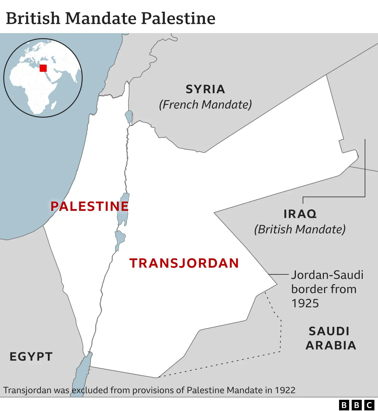
For centuries, the land encompassing present-day Israel and Palestine was part of the Ottoman Empire. Following the Ottoman Empire’s collapse after World War One, the territory of Palestine, specifically the region west of the Jordan River also historically significant to Jewish people, was designated to British administration under a mandate granted by the Allied powers and later endorsed by the League of Nations. This British Mandate of Palestine tasked Britain with establishing a “national home for the Jewish people,” while also safeguarding the civil and religious rights of existing non-Jewish communities within the territory.
 Map showing UN partition plan for Palestine
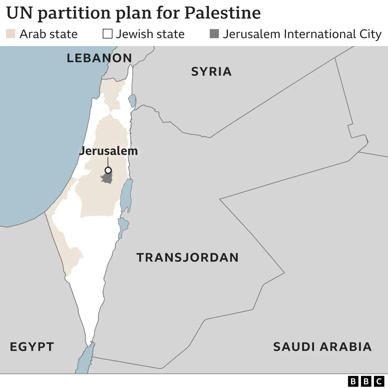
As both Palestinian Arab nationalism and Jewish immigration to Palestine grew, particularly during the rise of Nazism in the 1930s, tensions and violence escalated. Britain, facing increasing pressure, referred the issue to the United Nations. In 1947, the UN proposed a partition plan to divide Palestine into two states: one Arab and one Jewish, with Jerusalem and Bethlehem designated as an international zone. While the Jewish leadership accepted this plan, Arab leaders rejected it. This rejection laid the groundwork for further conflict and territorial disputes that continue to shape the map of Palestine and the region.
 Map showing the 1949 Armistice Lines
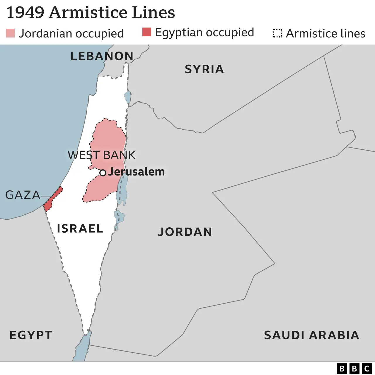
On May 14, 1948, as the British Mandate expired, the Jewish leadership declared the establishment of the State of Israel, without explicitly defining its borders. The following day, neighboring Arab armies entered the territory, initiating the 1948 Arab-Israeli War. The war concluded in 1949 with armistice agreements that established ceasefire lines between Israel and its neighbors. These lines resulted in the creation of the Gaza Strip, administered by Egypt, and the West Bank, including East Jerusalem, under Jordanian control. Arab states refused to recognize Israel, leaving its definitive borders unresolved and the location of Palestine further contested.
A significant shift in the geography of Palestine occurred in 1967 during the Six-Day War. Israel’s victory resulted in its occupation of the Sinai Peninsula, Gaza Strip, West Bank, East Jerusalem, and the Golan Heights from Syria. This occupation dramatically increased the territory under Israeli control. Israel subsequently annexed East Jerusalem and the Golan Heights, declaring unified Jerusalem as its capital. However, these annexations have not been widely recognized internationally, with most of the international community continuing to consider East Jerusalem and the Golan Heights as occupied territories. This ongoing occupation profoundly impacts the current understanding of where Palestine is geographically situated.
 Map showing Israel and region in 1982 after Israel-Egypt peace treaty
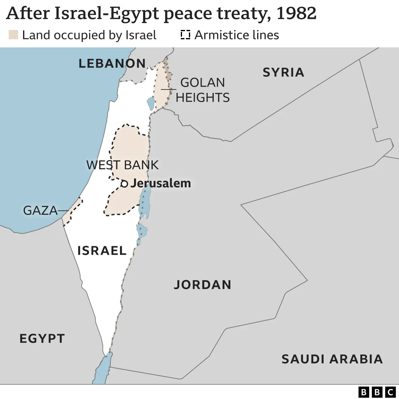
A formal border for Israel was established for the first time with Egypt in 1979, when Egypt became the first Arab nation to recognize Israel. The Israel-Egypt Peace Treaty defined their border, and Israel withdrew from the Sinai Peninsula by 1982. However, Israel continued to occupy the Gaza Strip, East Jerusalem, and the Golan Heights, with its other borders still largely defined by the 1949 armistice lines. Jordan became the second Arab state to recognize Israel in 1994, formalizing their shared border. While a peace treaty between Israel and Lebanon is absent, the 1949 armistice line serves as a de facto northern border. The border with Syria remains officially unsettled.
Since Israel’s withdrawal of troops and settlers from Gaza in 2005, a de facto border exists. However, the UN considers Gaza and the West Bank as a single occupied entity, with official borders yet to be determined. The final status of the West Bank, Gaza Strip, and East Jerusalem, areas where Palestinians live under Israeli occupation, are intended to be resolved through negotiations between Israelis and Palestinians. Decades of intermittent talks have not yet yielded a conclusive agreement.
The border surrounding the Gaza Strip has become increasingly fortified with security fences and concrete walls. This intensified security infrastructure was significantly expanded after Hamas, the militant group controlling Gaza, initiated tunnel raids into Israel in 2014. Despite these extensive barriers, Hamas militants breached the security perimeter in a major attack on October 7, 2023, highlighting the volatile and contested nature of the region’s boundaries.
In conclusion, pinpointing Palestine’s location on a map is not straightforward due to the ongoing Israeli-Palestinian conflict and the unresolved status of territories like the West Bank, Gaza Strip, and East Jerusalem. While Palestine is geographically situated in the Levant, bordering Israel, Jordan, Egypt, and the Mediterranean Sea, its political borders remain contested and subject to international negotiations. Understanding the historical maps and the evolution of borders is essential to grasping the complexities of Palestine’s location and the region’s ongoing geopolitical landscape.