
St. Thomas, a gem in the Caribbean, beckons travelers with its stunning beaches, vibrant culture, and rich history. But before you set your sights on this tropical paradise, you might be wondering: where exactly is St. Thomas Island?
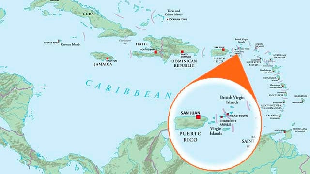
Nestled in the heart of the Caribbean archipelago, St. Thomas is part of the Virgin Islands, a captivating island chain that arcs gracefully from Florida towards South America. To pinpoint St. Thomas more precisely, picture yourself flying southeast from Miami, Florida for approximately 1,106 miles. Alternatively, imagine heading east from Puerto Rico for a mere 40-50 miles. There, amidst the turquoise waters, you’ll discover St. Thomas, basking in the Caribbean sun.
 Caribbean Map
Location of St. Thomas Island within the Caribbean region, showcasing its position in the Lesser Antilles arc, near Puerto Rico, and southeast of Florida.
To understand St. Thomas’s location more broadly, it’s helpful to know about the Greater and Lesser Antilles. The Caribbean islands are geographically categorized into these two groups. The Greater Antilles are the larger islands in the northwest, including Cuba, Jamaica, the Cayman Islands, Hispaniola (Haiti/Dominican Republic), and Puerto Rico. Moving eastward and southward, we encounter the Lesser Antilles, a collection of smaller islands. St. Thomas belongs to the Leeward Islands, the northernmost group within the Lesser Antilles.
Discovering the Virgin Islands Archipelago
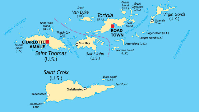
The Virgin Islands themselves are further divided, not geographically, but politically, into the United States Virgin Islands (USVI) and the British Virgin Islands (BVI). St. Thomas is a crown jewel of the U.S. Virgin Islands.
 Virgin Islands Map
Detailed map of the Virgin Islands, clearly delineating the US Virgin Islands (USVI) including St. Thomas, St. Croix, St. John, and Water Island, and the neighboring British Virgin Islands (BVI).
Exploring the U.S. Virgin Islands: St. Thomas and its Neighbors
The USVI are composed of four principal islands:
- St. Croix: The largest of the USVI, located about 40 miles south of St. Thomas.
- St. Thomas: Our focus island, known for its bustling harbor and capital, Charlotte Amalie.
- St. John: Located just a short 4-mile ferry ride east of St. Thomas, famous for its pristine National Park.
- Water Island: The smallest inhabited USVI, situated a mere half-mile off the south coast of St. Thomas.
These islands, along with approximately 50 smaller islets and cays, constitute the USVI, covering a total area of 133 square miles. St. Thomas, while not the largest at roughly 31 square miles, is geographically positioned centrally within this group, making it a convenient hub for exploring the other USVI and even the nearby BVI.
The British Virgin Islands: A Neighboring Paradise
Just to the northeast of the USVI lie the British Virgin Islands. The BVI consist of four main islands – Tortola, Virgin Gorda, Jost Van Dyke, and Anegada – and around 32 smaller islands, encompassing a total area of 59 square miles. While distinct in governance, the BVI share the stunning natural beauty and geological origins of the USVI.
The Geography of St. Thomas and the Virgin Islands
The Virgin Islands, both USVI and BVI, are essentially the peaks of a submerged mountain range rising from the ocean floor. These islands are characterized by hills and valleys, with most rising only a few hundred feet above sea level. The highest point in the Virgin Islands is actually Mount Sage in Tortola (BVI), reaching 1,710 feet. St. Thomas’s highest point, Crown Mountain, reaches a notable 1,556 feet, contributing to the island’s dramatic and scenic landscape.
The geography of St. Thomas itself is defined by a central ridge of hills running east to west, with smaller ridges branching off. This creates a varied terrain of seaside cliffs, lush forests in the mountains, small streams, and, of course, the iconic white sand beaches. St. Thomas boasts a beautiful natural harbor, Charlotte Amalie Harbor, which has historically been and continues to be a major draw for ships and visitors alike.
Why St. Thomas’s Location Matters for Your Trip
Understanding where St. Thomas Island is located is crucial for planning your Caribbean getaway. Its proximity to Puerto Rico makes it easily accessible from the continental US, often involving a direct flight to Puerto Rico followed by a short connecting flight or ferry. Its central position within the USVI makes island hopping to St. John and St. Croix straightforward. Furthermore, its location within the Leeward Islands places it in a prime Caribbean climate zone, known for warm temperatures and beautiful trade winds.
Whether you’re dreaming of relaxing on pristine beaches, exploring historic towns, or embarking on sailing adventures, knowing the precise location of St. Thomas Island is the first step in making your Caribbean dreams a reality.