 physical features of Syria
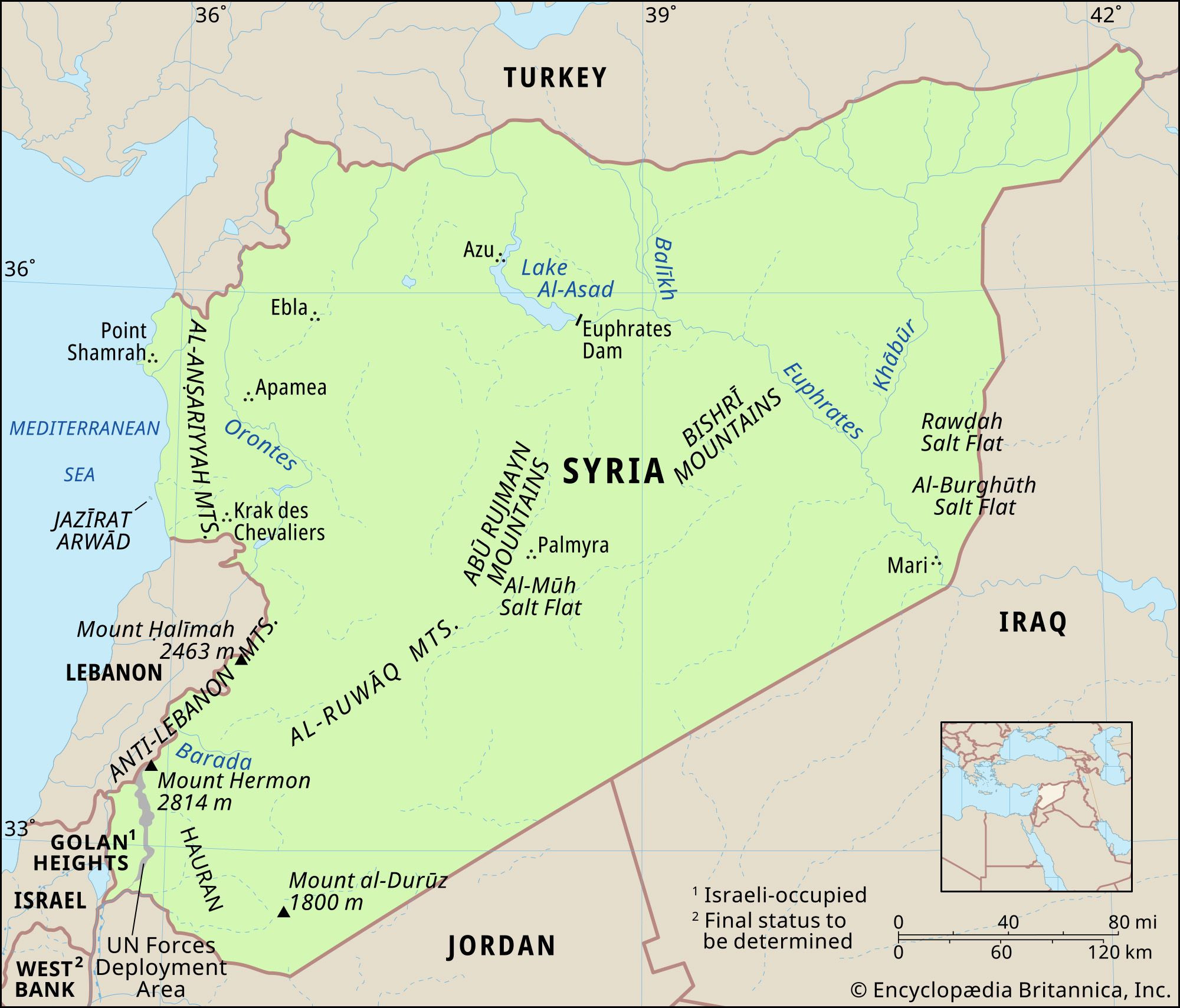
Syria, officially the Syrian Arab Republic, is a country located in Western Asia, specifically in the Middle East. Understanding Syria’s location in Asia is crucial to grasping its regional significance and diverse geographical features. Bordered by Turkey to the north, Iraq to the east and southeast, Jordan to the south, and Lebanon and Israel to the southwest, Syria occupies a strategically important area in the heart of the continent. Its western edge also meets the Mediterranean Sea, providing it with a coastline and maritime access. This unique positioning within Asia has historically made Syria a crossroads of civilizations and trade routes.
Syria’s Diverse Landscape: From Coastline to Desert
Syria, despite its relatively small size, boasts a remarkably diverse landscape. This geographical variety is a defining characteristic of the country within the Asian continent. The country can be broadly divided into several distinct geographical regions: the coastal strip, the western mountains, the inland plains, and the Syrian Desert.
Coastal Plains and Mountains
Syria’s Mediterranean coastline, though short at approximately 110 miles (180 km), is a significant feature. This coastal strip is characterized by sandy bays interspersed with rocky headlands and low cliffs. Moving inland from the coast, the Al-Anṣariyyah Mountains rise, running north to south and paralleling the coastline. These mountains, with average widths of 20 miles (32 km), gradually decrease in average height from north to south, ranging from 3,000 feet (900 meters) to 2,000 feet. The highest point in this range reaches 5,125 feet (1,562 meters) east of Latakia.
Directly east of the Al-Anṣariyyah Mountains lies the Ghāb Depression, a notable longitudinal trench stretching for 40 miles (64 km). This depression is home to the Orontes River valley (Nahr Al-ʿĀṣī), a vital water source for the region. Further east, marking Syria’s border with Lebanon, are the Anti-Lebanon Mountains (Jabal Al-Sharqī). This mountain range is more imposing, with the main ridge reaching a maximum height of 8,625 feet (2,629 meters) near Al-Nabk and an average height between 6,000 and 7,000 feet (1,800 to 2,100 meters). Mount Hermon (Jabal Al-Shaykh), Syria’s highest point, is part of this range, soaring to 9,232 feet (2,814 meters).
Inland Plains and the Syrian Desert
Beyond the western mountain ranges, the landscape of Syria transitions into undulating plains, which constitute a significant portion of the country and are part of the larger Syrian Desert. These plains typically lie between 980 and 1,640 feet (300 and 500 meters) in elevation, rarely falling below 820 feet (250 meters) above sea level. It’s important to note that the Syrian Desert is not a classic sand desert. Instead, it is characterized by a rock and gravel steppe. In the south-central area of this region, the mountainous area known as Al-Ḥamād is found. Smaller, scattered mountain ranges like Mount Al-Durūz in the extreme south and the Abū Rujmayn and Bishrī Mountains in the central part of the country further diversify the inland plains.
Rivers and Drainage Systems
Water resources are crucial in this region of Asia, and Syria’s drainage systems are defined by several key rivers and lakes. The Euphrates River is the most significant water source and the only navigable river in Syria. Originating in Turkey, it flows southeastward across eastern Syria. The Euphrates Dam, creating Lake Al-Asad, is a major water management project on this river.
 Tigris and Euphrates river basin
The Orontes River is the primary river of the western mountainous region. It flows northward from Lebanon through the mountains and the Ghāb Depression, eventually reaching the Mediterranean Sea near Antioch, Turkey. In the southwest, the Yarmouk River, a tributary of the Jordan River, drains the Jabal Al-Durūz and Hauran regions, forming part of the border with Jordan.
Scattered lakes, both seasonal and permanent, are also part of Syria’s landscape. Al-Jabbūl, a seasonal saline lake southeast of Aleppo, is the largest. Other notable salt lakes include Jayrūd northeast of Damascus and Khātūniyyah northeast of Al-Hasakah. Freshwater lakes like Lake Muzayrīb and the reservoir Lake Qattinah (Lake Homs) add to the diversity of water bodies. A significant aspect of Syria’s drainage is the prevalence of underground water flow due to porous rocks like basalt and limestone, leading to numerous springs and subterranean water sheets.
Climate and Soil: Influences of Asian Geography
Syria’s climate and soil composition are directly influenced by its location within Asia and its diverse geographical features. The country experiences a range of climatic conditions, primarily characterized by a Mediterranean climate in the west transitioning to arid conditions inland.
The coastal and western mountain regions enjoy a Mediterranean climate with a long, dry summer season from May to October. Summers are hot and winters are mild in these areas. Inland, the climate becomes increasingly arid, with greater temperature extremes – colder winters and hotter summers. The Syrian Desert regions experience the most extreme temperatures.
Precipitation levels vary significantly across Syria, reflecting its geographical zones. The coast and western mountains receive the highest rainfall, ranging from 30 to 40 inches (760 to 1000 mm) annually. Rainfall decreases sharply eastward, with the steppe receiving 10 to 20 inches (250 to 500 mm), and the desert area of Al-Ḥamād receiving less than 5 inches (130 mm) annually.
Soil composition in Syria is largely influenced by aridity, with vegetation playing a secondary role. Most soils, except for the black soil in the northeastern Al-Jazīrah region, are deficient in phosphorus and organic matter. Common soil types include various clays and loams, with calcareous soils and gypsum-containing soils also present. Alluvial soils are found mainly in the river valleys, reflecting the importance of water systems in shaping the landscape.
In conclusion, Syria’s location in Western Asia places it at a geographical and climatic crossroads. Its diverse landscape, ranging from Mediterranean coast to inland desert, and its vital river systems shape its environment and regional significance within the Asian continent.