The Jordan River, a name resonant with history, religion, and geographical intrigue, holds a significant place in the Middle East. This river, while not the longest or widest in the world, is arguably one of the most historically and religiously important, especially for those of Christian, Jewish, and Muslim faiths. But Where Is The Jordan River exactly located? Let’s delve into the geographical details of this iconic waterway.
Tracing the Jordan River’s Course: From Source to the Dead Sea
The Jordan River is situated in southwestern Asia, within the Middle East region. It carves a path through a structural depression, remarkably holding the distinction of having the lowest elevation of any river on Earth. Its journey begins on the slopes of the majestic Mount Hermon, a mountain straddling the border between Syria and Lebanon. From these heights, the river embarks on a southward trajectory, initially flowing through northern Israel towards the Sea of Galilee, also known as Lake Tiberius.
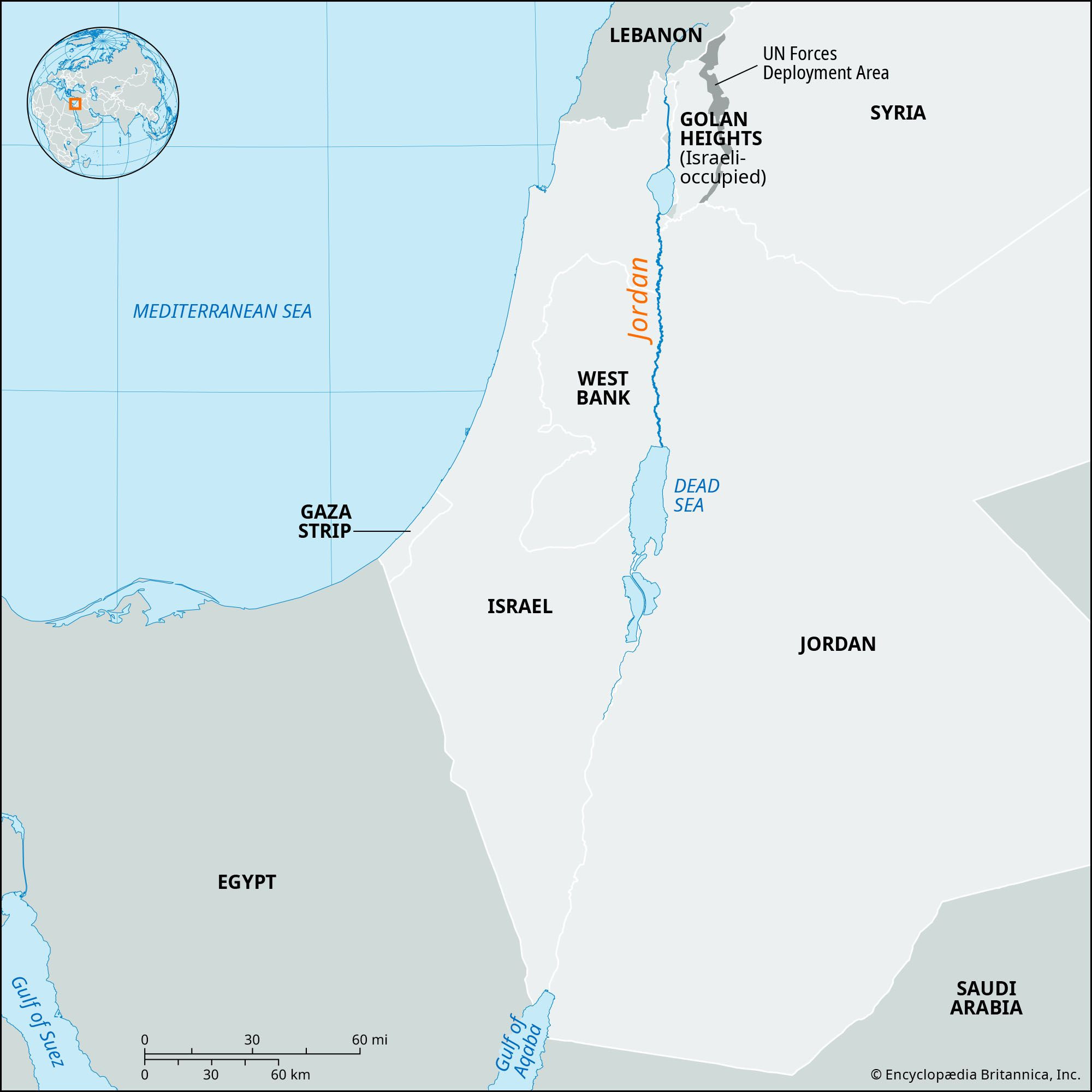 Locator map of the Jordan River showing its path through the Middle East
Upon exiting the Sea of Galilee, the Jordan River continues its southward flow, now serving as a natural boundary. It delineates the border between Israel and the Israeli-occupied West Bank to its west, and the Kingdom of Jordan to its east. Finally, after its winding journey, the river empties into the Dead Sea. Notably, the surface of the Dead Sea is the lowest land point on the planet, sitting approximately 1,410 feet (430 meters) below sea level, a measurement taken in the mid-2010s.
While the Jordan River stretches over 223 miles (360 kilometers) in length due to its meandering course, the direct distance from its source to the Dead Sea is considerably shorter, measuring less than 124 miles (200 kilometers). Historically, after 1948, the river became a frontier between Israel and Jordan, starting just south of the Sea of Galilee and extending to the point where the Yābis River joins it from the east. However, following the 1967 occupation of the West Bank by Israeli forces, the Jordan River effectively became the cease-fire line, extending southward to the Dead Sea.
The Physical Geography of the Jordan River Valley
The Jordan River flows through the Jordan Valley, a significant geographical feature that is part of the larger East African Rift System. This rift valley is a north-south geological fault line that extends from southern Turkey, through the Red Sea, and into eastern Africa. The Jordan Valley itself is characterized by a long, narrow trough, averaging about 6 miles (10 kilometers) in width, although it narrows in certain areas, particularly at both ends of the Sea of Galilee.
Throughout its course, the valley floor lies significantly lower than the surrounding terrain. This is especially pronounced in the south, where the land surrounding the river can rise dramatically, reaching elevations of 3,000 feet (900 meters) or more above the riverbed. The valley walls are steep, stark, and largely barren, punctuated only by the deep gorges carved by tributary wadis, which are seasonal watercourses that flow during wetter periods.
Sources and Tributaries Feeding the Jordan River
The Jordan River is primarily fed by three main sources, all originating at the base of Mount Hermon. The longest of these is the Ḥāṣbānī River, which rises in Lebanon, near Ḥāṣbayyā, at an elevation of 1,800 feet (550 meters). From the east, originating in Syria, flows the Bāniyās River. Located between these two is the Dan River, renowned for its particularly fresh and clear waters.
These three rivers converge within Israel, in the Hula Valley. Historically, the Hula Valley was a marshy lake area, but in the 1950s, a significant portion, approximately 23 square miles (60 square kilometers), was drained for agricultural purposes. However, by the 1990s, soil degradation and flooding issues led to a reversal of this decision. The area was subsequently re-established as a protected nature reserve, allowing the lake and surrounding wetlands to recover, and encouraging the return of native flora and fauna, most notably migratory birds.
At the southern end of the Hula Valley, the Jordan River carves through a basalt barrier, descending sharply towards the northern edge of the Sea of Galilee. The Sea of Galilee plays a crucial role in regulating the river’s flow. Exiting from the southern shore of the Sea of Galilee, the Jordan River receives its most significant tributary, the Yarmūk River. The Yarmūk marks a section of the border between Syria and Jordan. Further downstream, the Jordan is joined by two additional tributaries: the Ḥarod River on its right bank and the Yābis River on its left.
Beyond this confluence, the Jordan River’s plain expands to a width of approximately 15 miles (24 kilometers), becoming remarkably uniform. This flat, arid terrain, known as the Ghawr (or Ghor), is characterized by terraces dissected by wadis and rivers, forming a rugged landscape of rocky towers, pinnacles, and badlands, often likened to a lunar surface.
The valley that the Jordan River has carved into the plain ranges in width from about 1,300 to 10,000 feet (400 to 3,000 meters) and in depth from approximately 50 to 200 feet (15 to 60 meters). Along this stretch, the Jordan’s floodplain, known as the Zūr, is characterized by numerous meanders. Despite a course of about 135 miles (215 kilometers) between the Sea of Galilee and the Dead Sea, the actual straight-line distance is only 65 miles (105 kilometers). The Zūr, prone to frequent flooding, was once covered in dense vegetation, including reeds, tamarisk, willows, and white poplars. However, the construction of dams to manage the river’s flow has enabled the conversion of much of this land into irrigated agricultural fields. Finally, the Jordan River empties into the Dead Sea through a gently sloping, broad delta.
Climate and Hydrology
While the plateaus bordering the Jordan Valley receive relatively ample rainfall, the valley itself is not particularly well-watered. The Hula Valley receives about 22 inches (550 mm) of rainfall annually, while areas north of the Dead Sea receive only about 3 inches (75 mm). Winters along the river are generally mild, especially in the southern reaches, but summers are intensely hot, with temperatures increasing towards the south.
The Jordan River’s water source is primarily rainfall on the adjacent plateaus, which drains into the river through various rivers and wadis. The river itself is relatively shallow. Its high-water period typically occurs from January to March, while its low-water period is at the end of summer and the beginning of autumn. The river’s current is notably swift, and it carries a significant amount of silt. However, the flow rate decreases as it progresses downstream due to evaporation and water seepage. The Yarmūk River once nearly doubled the Jordan’s flow, but upstream damming has reduced its contribution. The presence of thermal springs, particularly near Tiberias on the western side of the Sea of Galilee, and the concentration of gypsum contribute to the Jordan’s relatively high salinity, which can leave salt deposits in the soil when used for irrigation.
Historical and Religious Significance of the Jordan River
Historically, the Jordan River was known as the Aulon by ancient Greeks and is sometimes referred to as Al-Sharīʿah (“Watering Place”) by Arabs. However, its significance transcends geographical description. The Jordan River is revered by Christians, Jews, and Muslims alike. For Christians, it is the sacred site where Jesus Christ was baptized by St. John the Baptist. This event is a cornerstone of Christian faith, and the Jordan River remains a significant pilgrimage destination and a site for baptisms for Christians around the world.
In Jewish tradition, the Jordan River marks the eastern border of the Promised Land and holds symbolic importance in several biblical narratives. While not as central to Islamic rituals, the river is still respected within Islamic tradition as part of the Holy Land.
In conclusion, the Jordan River is located in the Middle East, flowing south from the slopes of Mount Hermon, through Israel and along the border of the West Bank and Jordan, finally emptying into the Dead Sea. Its geographical location is intertwined with its profound historical and religious significance, making it a river of immense importance far beyond its physical size.