The US Virgin Islands, often abbreviated as USVI, are a captivating archipelago nestled in the heart of the Caribbean Sea. This idyllic location places them within the expansive arc of Caribbean islands, a stunning chain that begins near Florida and gracefully curves towards South America. This region, renowned for its breathtaking beauty, encompasses a multitude of islands and cays, each contributing to the Caribbean’s unique charm.
Unveiling the Caribbean Archipelago: Greater and Lesser Antilles
 Caribbean Map
The Caribbean islands are geographically categorized into two main groups: the Greater Antilles and the Lesser Antilles. The Greater Antilles comprises the larger islands situated in the northwestern part of the Caribbean. This group includes prominent islands such as Cuba, Jamaica, the Cayman Islands, Hispaniola (shared by Haiti and the Dominican Republic), and Puerto Rico. In contrast, the Lesser Antilles encompasses the remaining islands, stretching from the Virgin Islands in the Leeward Islands to the Windward Islands in the southeast, and further to the islands just north of Venezuela. The US Virgin Islands are an integral part of the northerly Leeward Islands within the Lesser Antilles.
Pinpointing the US Virgin Islands
 Virgin Islands Map
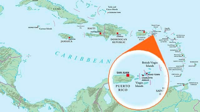
Specifically, the US Virgin Islands are positioned approximately 40 to 50 miles to the east of Puerto Rico. For those seeking a broader geographical context, the USVI are situated roughly 1106 miles southeast of Miami, Florida. This strategic location in the Caribbean places the USVI as a sought-after destination, easily accessible yet distinctly secluded.
It’s important to note that the Virgin Islands archipelago is shared between two nations: the United States and the United Kingdom. This division results in two distinct entities: the United States Virgin Islands (USVI) and the British Virgin Islands (BVI).
Exploring the U.S. Virgin Islands
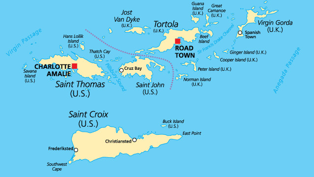
The US Virgin Islands are composed of four principal islands: St. Croix, St. Thomas, St. John, and Water Island. Adding to their charm are approximately 50 smaller islets and cays that dot the surrounding waters. Collectively, the USVI encompass a total land area of 133 square miles, offering a diverse range of landscapes and experiences.
Discovering the British Virgin Islands
The British Virgin Islands (BVI), located to the northeast of the USVI, consist of four main islands: Tortola, Virgin Gorda, Jost Van Dyke, and Anegada. Complementing these larger islands are 32 smaller islands, contributing to a total land area of 59 square miles for the BVI.
Geographical Overview of the Virgin Islands
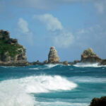
Both the USVI and BVI share a fascinating geological origin. These islands are essentially the peaks of submerged mountains rising from the ocean floor. The majority of these islands ascend to only a few hundred feet above sea level, creating a relatively low-lying profile. The highest point within the Virgin Islands is Mount Sage, situated on Tortola in the BVI, reaching an elevation of 1,710 feet. The diverse geography of the islands is characterized by dramatic seaside cliffs, verdant mountains covered in lush forests, small, meandering streams, arid regions, and pristine white sand beaches, offering a rich tapestry of natural beauty.
Delving Deeper into the USVI Islands
Virgin Islands Travel Insights
St. Croix, USVI
St. Croix, the largest of the USVI, spans 84 square miles, measuring 22 miles in length and just over 6 miles at its widest point. The eastern part of St. Croix presents a rocky and arid landscape, characterized by short grassy hills and clusters of cactus. In contrast, the western end is remarkably lush, adorned with mature fruit trees and ferns that grace the mountainsides. The central region of the island boasts miles of stunning beaches, gently rolling pasturelands, and picturesque scenery. Mount Eagle, St. Croix’s highest peak, rises to 1,088 feet. The terrain gradually flattens towards the southern coast. The island is home to two primary towns, Frederiksted and Christiansted, along with several natural harbors and sheltered bays. St. Croix is located approximately 40 miles from St. Thomas. St. Croix Travel Guide →
St. Thomas, USVI
St. Thomas, renowned for its central ridge of hills running east to west, with smaller ridges branching outwards, covers a little over 31 square miles. It is thirteen miles long and four miles wide. Crown Mountain, the highest point, reaches 1,556 feet. St. Thomas features a magnificent natural harbor and numerous protected bays. Charlotte Amalie, the historic capital of the Virgin Islands, is nestled on St. Thomas. While St. Thomas is largely hilly, its downtown area is a notable exception, offering flatter terrain. St. Thomas Travel Guide →
St. John, USVI
St. John, situated about 4 miles east of St. Thomas, is characterized by hills and valleys with limited flatlands. Encompassing 20 square miles of breathtaking scenery, St. John is 7 miles long and 3 miles wide. Bordeaux Mountain, its highest point, stands at 1,277 feet. The coastline is indented with numerous small, sheltered bays. Coral Bay provides a natural harbor, while Cruz Bay serves as the main town and harbor. Remarkably, over two-thirds of St. John is protected as a National Park. St. John Travel Guide →
Water Island, USVI
Water Island, the smallest inhabited island within the USVI group, is just 491.5 acres in size. Irregularly shaped with numerous bays and peninsulas, Water Island is 2½ miles long and ½ to 1 mile wide. Its highest point reaches 300 feet above sea level. It is conveniently located only half a mile off the south coast of St. Thomas. Water Island Travel Guide →