Georgia, a country of captivating landscapes and rich history, often sparks curiosity about its location. Nestled at the crossroads of Eastern Europe and Western Asia, Georgia offers a unique blend of cultures and environments. This article delves into the geographical position of Georgia, exploring its diverse terrain, climate, and biodiversity, offering a comprehensive understanding of this fascinating country.
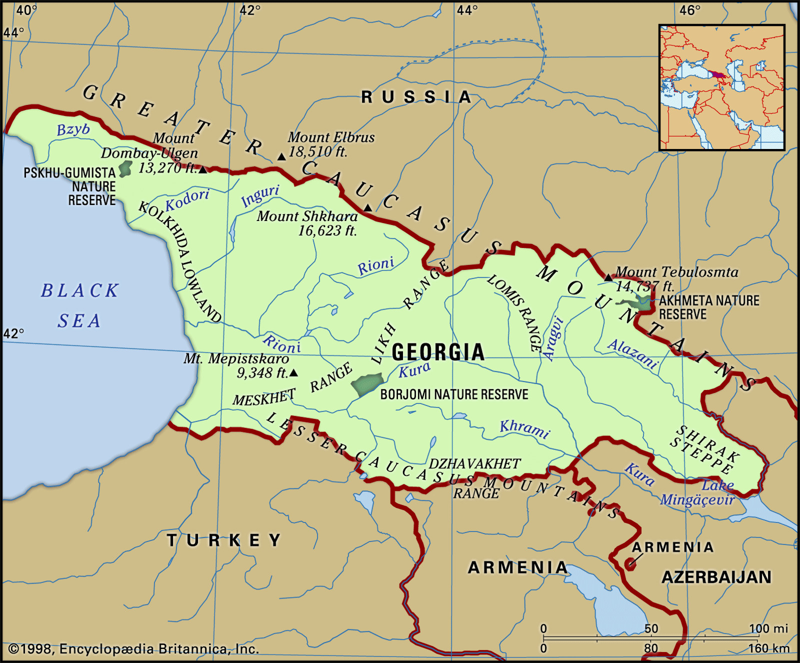
Georgia’s unique geographical setting is defined by its position in the Caucasus region. Bordered by Russia to the north, Azerbaijan to the east, Turkey and Armenia to the south, and the Black Sea to the west, Georgia occupies a strategic location. This placement has historically made it a bridge between continents and civilizations, influencing its culture and development. The country’s terrain is predominantly mountainous, a defining feature shaped by the Greater Caucasus range to the north and the Lesser Caucasus to the south.
The Diverse Terrain of Georgia in the Caucasus Region.
The landscape of Georgia is remarkably varied for its size, spanning from subtropical Black Sea coastlines to towering, snow-capped mountains. This diversity can be broadly categorized into three east-west bands. The northernmost band is dominated by the imposing Greater Caucasus Mountains. This formidable mountain range acts as a natural border with Russia and features some of Georgia’s highest peaks, including Mount Shkhara, the country’s highest point at 16,627 feet (5,068 meters). Other notable peaks like Mount Rustaveli, Tetnuldi, and Ushba contribute to the dramatic skyline. The volcanic cone of Mount Kazbek (Mkinvari) further punctuates this range, adding to the region’s majestic beauty. Numerous spurs extend southward from the central range, creating deep gorges and valleys carved by glacial rivers.
Moving south, the landscape transitions into central lowlands, a structural depression formed between the Greater and Lesser Caucasus ranges. The Kolkhida Lowland, an ancient area known as Colchis, is a fertile plain bordering the Black Sea. This area is characterized by thick layers of river sediments deposited over millennia by rivers originating in the Greater Caucasus, such as the Inguri, Rioni, and Kodori. Historically a swampy region, extensive drainage projects have transformed the Kolkhida Lowland into a vital agricultural area, renowned for subtropical crops.
The southern band of Georgia is characterized by the Lesser Caucasus Mountains and associated plateaus. Rising beyond a narrow coastal plain, these ranges, while lower than the Greater Caucasus, still reach significant heights, with Didi-Abuli peak reaching 10,830 feet. The Meskhet and Likh ranges further connect the Greater and Lesser Caucasus, acting as a crucial watershed dividing the Black and Caspian Sea basins. Between these ranges, in central Georgia, lies the Kartli Plain, an inner high plateau historically significant as the location of the ancient capital, Mtskheta.
Georgia’s climate is as varied as its terrain, influenced by the Black Sea and the protective barrier of the Caucasus Mountains. Western Georgia experiences a humid subtropical climate, heavily influenced by warm, moist air from the Black Sea. This region sees significant rainfall throughout the year, ranging from 40 to 100 inches (1,000 to 2,500 mm), with autumn and winter being the wettest seasons. Winters are mild, particularly in the coastal areas of Kolkhida, where January temperatures rarely drop below freezing. Summers are moderately warm, averaging around 71°F (22°C).
Eastern Georgia, situated inland, has a more varied climate, ranging from moderately humid to dry subtropical. Precipitation decreases as you move eastward, with the plains and foothills receiving 16 to 28 inches of rainfall. Mountainous areas, however, receive significantly more. Southeastern regions are the driest, with rainfall peaking in late spring. Summer temperatures in the lowlands can reach around 77°F (25°C) in July, while January temperatures range from 32 to 37°F (0 to 3°C). Elevation plays a crucial role, with distinct climate zones ranging from subtropical at lower altitudes to alpine conditions at higher elevations, where snow and ice persist year-round.
This diverse geography and climate foster a rich tapestry of plant and animal life. Georgia’s landscapes range from lush subtropical forests along the Black Sea coast to alpine meadows and even semi-arid steppes in the east. Forests cover over a third of the country, particularly in the west, harboring species like oak, chestnut, beech, and alder, alongside relict species like the Pitsunda pine. The undergrowth is dense with evergreens, rhododendrons, and various shrubs, creating a vibrant ecosystem. Eastern Georgia, while less forested, features steppes with grasses and prickly shrubs, transitioning to alpine vegetation at higher altitudes.
Georgia’s fauna is equally diverse. The high mountains are home to goats and Caucasian antelope, while rodents inhabit alpine meadows. Birdlife is abundant, including mountain turkeys, Caucasian black grouse, and eagles. Rivers and lakes teem with trout. Forest regions shelter wild boars, deer, bears, lynx, wolves, foxes, and various bird species. Lowland areas and rivers are rich in fish, and introduced species like raccoons and nutrias have also found a home.
In conclusion, when considering “Where Is Georgia Country”, it is essential to understand its location in the Caucasus, bridging Europe and Asia. Georgia’s diverse geography, from the towering Greater Caucasus Mountains to the fertile Kolkhida Lowland and the Black Sea coast, coupled with its varied climate and rich biodiversity, makes it a truly unique and captivating country. Its strategic location and natural beauty continue to intrigue and attract those eager to explore its wonders.


