The Marshall Islands, officially known as the Republic of the Marshall Islands (RMI), is a nation situated in the vast expanse of the central Pacific Ocean. Often when people ask, “Where Is Marshall Islands?”, they are seeking to understand its precise location within the world’s geography and its context within the Pacific region. This article will delve into the geographical details of this unique island nation, highlighting its key features, neighboring countries, and what makes its location so distinctive.
 Aerial view of a lush green island in the Marshall Islands, showcasing the typical atoll landscape of this Micronesian nation.
Geographical Location and Context
To answer the question “where is Marshall Islands?” directly, it’s essential to place it within its broader geographical context. The Marshall Islands are part of Micronesia, a subregion of Oceania in the Pacific Ocean. Specifically, they form the easternmost island group within Micronesia. Imagine a point roughly halfway between Hawaii and Australia – that’s where you’ll find this archipelago.
The nation is composed of two parallel island chains: the Ratak (Sunrise) Chain to the east and the Ralik (Sunset) Chain to the west. These chains are approximately 125 miles (200 kilometers) apart and extend for about 800 miles (1,287 kilometers) in a northwest-to-southeast direction. This scattering across a significant swathe of the Pacific Ocean underscores the remote and dispersed nature of the Marshall Islands.
Key Islands and Atolls
The Marshall Islands are made up of over 1,200 islands and islets, primarily organized into 29 coral atolls and five individual coral islands. The nominal capital, Majuro Atoll, serves as the center of government, with offices located in Delap-Uliga-Djarrit (DUD), an area formed by joining three formerly separate islands with landfill. Another significant atoll is Kwajalein, renowned as the world’s largest atoll by lagoon area. While its landmass is relatively small, the lagoon it encloses is vast, covering 655 square miles. Kwajalein is also notable for hosting a U.S. missile testing range, which significantly influences the local economy.
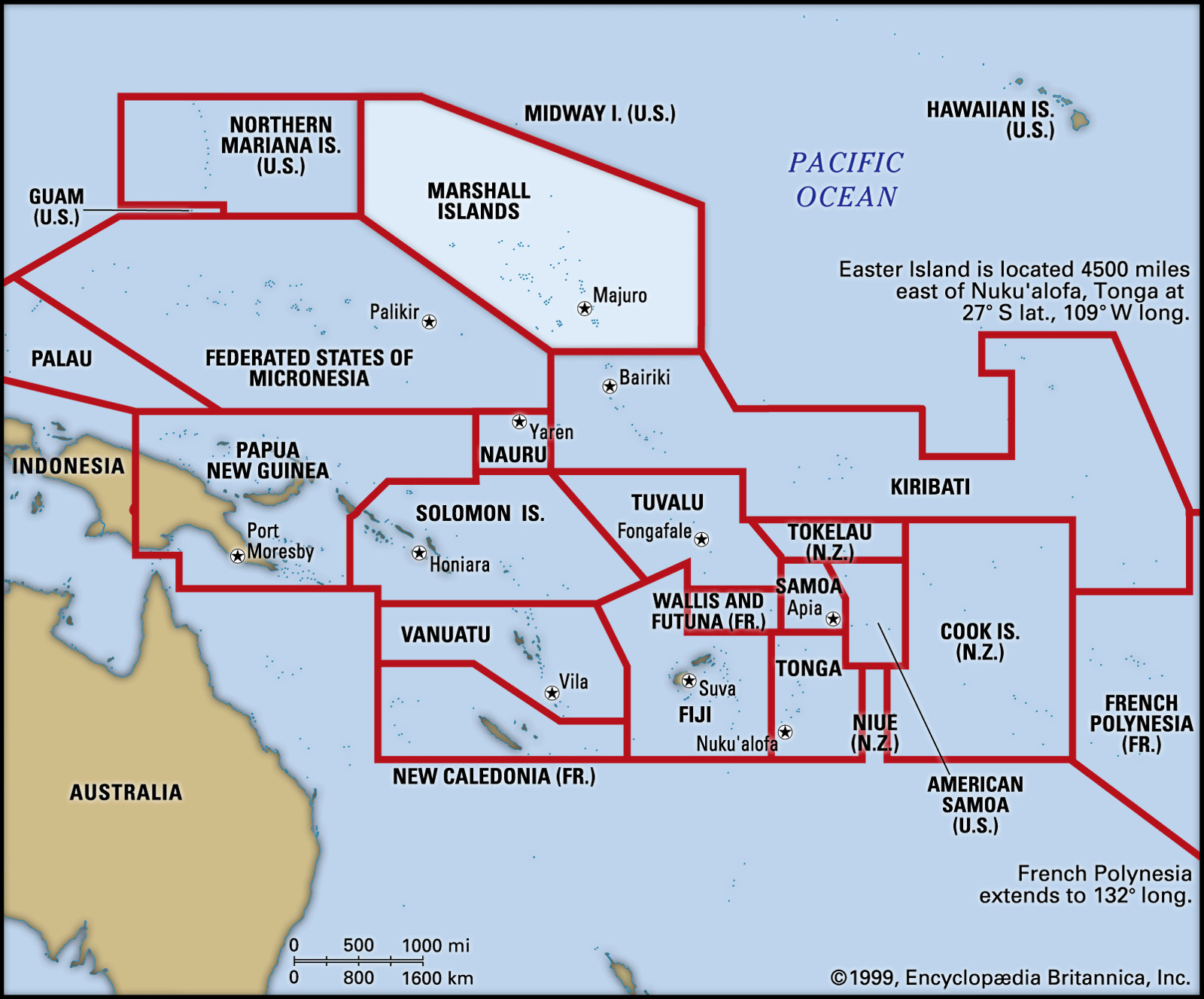
Understanding “where is Marshall Islands?” also involves recognizing its neighbors. To the north lies Wake Island, while Kiribati and Nauru are situated to the south. To the west, you’ll find the Federated States of Micronesia. These neighboring island nations, while distinct, share a similar Pacific island environment and history.
Climate and Environment
The climate across the Marshall Islands is consistently tropical, with an average annual temperature of 82°F (28°C). Rainfall varies considerably from north to south, ranging from 20 to 30 inches annually in the northern atolls to as much as 160 inches in the southern regions. October and November are typically the wettest months. The northern atolls, facing drier conditions, are often uninhabited due to limited freshwater availability.
Geologically, these islands are low-lying coral atolls, none rising more than 20 feet (6 meters) above sea level. They are essentially coral caps atop submerged volcanoes. The vegetation is characterized by coconut and pandanus palms, along with breadfruit trees, typical of atoll environments. The soil is generally sandy and not particularly fertile.
People and Culture
The indigenous population, known as the Marshallese, are Micronesian people. The majority of the population is concentrated in Majuro and Kwajalein atolls, drawn by employment opportunities and modern amenities. The outer islands maintain more traditional village lifestyles. Christianity is the dominant religion, introduced by American missionaries in the 19th century. Marshallese and English are the spoken languages, although English fluency is not universal.
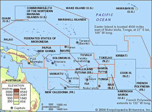 Map of Pacific Islands region, pinpointing the Marshall Islands within Micronesia, and its proximity to other island nations in the Pacific.
Economy and Livelihood
The Marshall Islands’ economy is significantly supported by U.S. subsidies, a key component of the Compact of Free Association with the United States. Land leases for the U.S. missile testing range on Kwajalein also provide substantial revenue. The concentration of jobs and modern facilities in Majuro and Kwajalein acts as a pull factor for internal migration.
In contrast, the outer islands rely more on subsistence farming, fishing, and raising livestock such as pigs and poultry. Copra production is a primary source of income for these outer island communities. The nation imports processed foods, machinery, transport equipment, manufactured goods, and fuels, mainly from the United States, Japan, and Australia.
Government and Society
The Marshall Islands operate as a republic with a government structure established by its 1979 constitution. A president, elected by the unicameral parliament (Nitijela), heads the government. The Council of Iroij (Chiefs) serves in an advisory role concerning traditional laws and customs. Healthcare services are provided through hospitals in Majuro and Ebeye and dispensaries on other islands. Education is available across the inhabited islands with primary schools and secondary schools on Majuro and Jaluit atolls, along with the College of the Marshall Islands in Majuro.
In Conclusion
So, where is Marshall Islands? It is a nation geographically located in the central Pacific Ocean, within the Micronesian subregion of Oceania. Comprising a dispersed set of atolls and islands, the Marshall Islands are a unique and important part of the Pacific, with a rich history, distinct culture, and a significant geopolitical position. Understanding its location is the first step to appreciating the diverse facets of this island nation.